
Trans Canada Trail
| Trans Canada Trail | ||
|---|---|---|
Right of way Multiple | | |
| Website | tctrail | |
The Trans Canada Trail, officially named The Great Trail between September 2016[1] and June 2021,[2] is a cross-Canada system of greenways, waterways, and roadways that stretches from the Atlantic to the Pacific to the Arctic oceans. The trail extends over 24,000 km (15,000 mi); it is now the longest recreational, multi-use trail network in the world. The idea for the trail began in 1992, shortly after the Canada 125 celebrations. Since then it has been supported by donations from individuals, corporations, foundations, and all levels of government.[3][4]
Trans Canada Trail (TCT) is the name of the non-profit group that raises funds for the continued development of the trail. However, the trail is owned and operated at the local level.
On August 26, 2017, TCT celebrated the connection of the trail with numerous events held throughout Canada. TCT has said it now plans to make the trail more accessible, replace interim roadways with off-road greenways, add new spurs and loops to the trail, and fund emergency repairs when needed.
Origin of trail idea
The creation of the trail was born of Canada's 125th anniversary celebrations in 1992.
Funding
The Trans Canada Trail has been funded largely by Canadian federal and provincial governments, with significant contributions from corporate and individual donors. The first province to have completed its designated section of the trail was Prince Edward Island (see Confederation Trail).
Development and maintenance
The network of the Trans Canada Trail is made up of more than 400 community trails. Each trail section is developed, owned, and managed locally by trail groups, conservation authorities, and by municipal, provincial, territorial, and federal governments, for instance in parks such as Gatineau Park or along existing trails such as the Cataraqui Trail and Voyageur Hiking Trail. The Trans Canada Trail supports the construction and use of greenways to replace roadways.
Moreover, considerable parts of the trail are repurposed defunct rail lines donated to provincial governments by
Thousands of Canadians, community partner organizations, corporations, local businesses, and all levels of government are involved in developing and maintaining these trails. TCT does not own or operate any section of the trail. As an ensemble, the Trans Canada Trail might be one of the largest volunteer projects ever undertaken in Canada.

Routes and amenities
The main section runs along the southern areas of Canada, connecting most of Canada's major cities and most populous areas. There is also a long northern arm that runs through Alberta to Edmonton and then up through northern British Columbia to the Yukon.
While the route described above has the TCT going east–west through the southern prairie provinces (via Medicine Hat and Calgary), with a northern branch going off to Edmonton and on to the north, the Trans Canada Trail officially is shown as going from Winnipeg across the northern Prairies, coming into Alberta east of Edmonton, spawning a northern walking trail near Fort Saskatchewan before entering Edmonton, then going south to Calgary and west to BC.[6]
The trail is multi-use and depending on the section may allow
"
.Future developments
While the trail is connected, TCT stated that it will continue to fundraise for its future development and enhancement. Among its objectives, TCT says that it plans to replace interim roadways with off-road greenways, where possible, to make it safer and more accessible for all users; to add new trail sections, and to provide emergency funding for trail sections damaged by natural disasters, etc.
The trail is not owned or operated by TCT, but the organization provides support to local partners and volunteer groups who maintain individual sections.
On September 4, 2018, TCT announced that the government of Canada would invest $30 million in trail development in the next four years. The official announcement was made by Catherine McKenna, Minister of Environment and Climate Change.[7]
Controversy
Edmund A. Aunger, professor emeritus of political science at the University of Alberta, Campus Saint-Jean, is a vocal critic of the trail, particularly in the way it has strayed from the original vision of "a trail built far enough from roads to mask traffic noise and avoid collisions".[8]
Because only 32 per cent (i.e. 7,898 km [4,908 mi]) of the Trans Canada Trail consists of actual off-road trails, the Trans Canada Trail is fundamentally very different from classic pure-hiking trails like the Appalachian Trail. Furthermore, not all of the off-road trails are hiking-only. Also, because many sections are on-road, cycling is more suitable for those stretches. Additionally, since some sections are on waterways, a cross-country trekker cannot rely on any one mode of transportation alone.[9]
Aunger states that "Lacking both uniform standards and control, the Trans Canada Trail includes a confusing and dangerous hodgepodge of mountain-bike paths, roadside ditches, dirt ruts, gravel roads and hazardous ATV trails."[8]
In 2012, Aunger's wife, Elizabeth Ann Sovis, was killed while cycling on a portion of the trail in Prince Edward Island.[8]
Infrastructure and route details by province and territory
This section needs expansion with: information about infrastructure in other provinces/territories. You can help by adding to it. (June 2014) |

Newfoundland and Labrador
As of May 2017,
The route continues as the Newfoundland T'Railway southwest, passing through the east side of
The trail changes to Gambo to Terra Nova Trail as it continues to Alexander Bay, then route 1, then Route 320 as it enters Gambo.
Continuing north, the next leg of the trail is called
The next section is
Now known as
The next stretch is called the
Continuing south, the route is now known as
The last stretch of the trail in Newfoundland is known as the
Nova Scotia
In Nova Scotia, the trail begins where it is known as Pottle Lake to North Sydney, on Cape Breton Island in the town of North Sydney, separating itself from Highway 105 after the ferry ride from Newfoundland. As of June 2014, this portion of the route has not been completed; however, it is planned to travel through the town and cross Highway 125 following Old Branch Road on the North Side of Pottle Lake.
From here, the trail changes to Old Branch Road - George River Division and continues through
The route continues as Upper Leitches Creek to Scotch Lake, briefly merging with Route 223 on the Bras D'or Lakes Scenic Drive, then follows Upper Leitches Creek Road as it enters Upper Leitches Creek.
At this point it changes to the Scotch Lake – Grand Narrows trail as it continues on Tower Road, then passes the
Celtic Shores Coast Trail
The Trans Canada Trail continues, passing Route 395 and going through Scotsville to a fork north of Strathlorne in the Municipality of the County of Inverness.
Halifax, Dartmouth, Cole Harbour, and Eastern Shore area
The only trail in Halifax is the Halifax Boardwalk. The boardwalk travels from Pier 21 to near Casino Nova Scotia. There are two trails in Dartmouth. The Dartmouth Waterfront Trail starts at Alderney Landing and ends in Woodside. The other trail goes by two names: Dartmouth Multi-use Trail and Shubie Canal Greenway. The trail visits Dartmouth's best parks, including Shubie Park. The Trans Canada Trail continues straight on trail from Shearwater to Meaghers Grant. Shearwater Flyer Trail, Forest Hills Trail System, Salt Marsh Trail, Atlantic View Trail, Blueberry Run Trail, Gaetz Brook Greenway and Musquodoboit Trailway are the names of the rest of the area's trails. Out of the region, the Trans Canada Trail continues on roads.
The North Trail or North Path travels north and ends in Inverness.
The South Trail passes through Strathlorne, then through Loch Ban, and then Black River, where its name changes to Mabou Rivers Trail. From here it passes through Glendyer, then crosses
Prince Edward Island
Prince Edward Island's portion of the Trans Canada Trail is known as the Confederation Trail. The main section runs from Tignish at kilometre 0 to Elmira at kilometre 273. Spurs extend to Charlottetown, Georgetown, Montague, Murray River, Murray Harbour, Souris, Wood Islands, and to the Confederation Bridge in Borden-Carleton, which links the Island with New Brunswick on the Canadian mainland.
New Brunswick
Quebec
Much of the trail's current route through Quebec follows the Route Verte and has many cycling paths. Completed off-road hiking trails can be found in Gatineau Park and along a route linking the Papineau-Labelle Nature Reserve, Mont Tremblant Provincial Park, and the Mastigouche Nature Reserve. These form part of a planned hiking route that would eventually link Ottawa-Gatineau on the Ontario border with the Gaspe Peninsula and the New Brunswick border.
Ontario
As a legacy project of the 2015 Pan American Games and the 2015 Parapan American Games, the Pan Am Path helps complete the 250 kilometres (160 mi) of gaps in Ontario's portion of the Trans Canada Trail.[11] In 2013, a one-kilometre-long honorary segment of the Trans Canada Trail was opened on the grounds of Rideau Hall in Ottawa. The Lake Huron-North Channel Waterfront route reduces use of shoulders along the Trans-Canada Highway by about 50 kilometres.
Prairie provinces
The route through Manitoba is a mix of off-road hiking trails, road shoulders, and waterways.
Saskatchewan has managed to avoid major highways and paved roads and uses nothing more than rural gravel roads to link off-road hiking trails. The route through this province has been proclaimed as complete with the opening of the Wakamow Valley Suspension Bridge. However, parts of the land route include some waterways that require a canoe or small boat.
The off-road sections of the trail are very fragmentary in Alberta, where opposition[12] to the trail by special interest groups[13] has been very strong. A major section in Alberta follows highway 2A between Edmonton and Calgary, a road that combines narrow shoulders with heavy traffic. The main role of the Alberta government so far has been to assist local trail associations in searching for better routes. Multi-use trails in the city of Fort Saskatchewan and Sturgeon County are planned to be connected with a new pedestrian bridge spanning the North Saskatchewan River, which was funded as part of a project to completely twin Highway 15 in the region.[14][15]
East of Edmonton, the TCT from Elk Point to Waskatenau uses the Iron Horse Trail, which lies on the old route of the Oliver–St. Paul rail line once operated by the Canadian Northern Railway (later the Canadian National). The Iron Horse Trail allows use of feet, quads, and horses. At Waskatenau, the trail veers south to the banks of the North Saskatchewan River and winds westward to Fort Saskatchewan.[6]
Just north of Fort Saskatchewan, the TCT forks, with the "Northern walking trail" winding north to Athabasca, across northern Alberta, northern BC, and the Yukon. At Athabasca, the northern walking trail spawns a water trail that takes travellers down the Athabasca River to the Mackenzie and thence to the Arctic Ocean.[6]
British Columbia
The main leg of the trail enters British Columbia from Alberta, following the
Northwest Territories
The Northwest Territories is where the Trans Canada Trail meets the Arctic Ocean. The land-based trail comes through the Yukon up the Dempster Highway and into the N.W.T., where it continues north through the Mackenzie Delta to Tuktoyaktuk, the most northern point on the Trans Canada Trail. There is also a significant portion of the water-based trail in the N.W.T. that comes from Alberta via the Slave River, across Great Slave Lake and north along the Mackenzie River to the Arctic Ocean.
There is a small section of the trail on Baffin Island, Nunavut, from the capital city of Iqaluit south along the Itijjagiaq trail to Kimmirut.
Yukon
The Yukon provides the land link between British Columbia and the Arctic. The trail enters the Yukon from British Columbia on the Alaska Highway, south of Watson Lake. Due to the vast distances and sparse population, the Yukon's section of trail mainly follows the highway network between communities, branching off onto smaller multiuse trails near most settlements. Many of these multiuse trails are also historically significant routes, including the Copper Haul Trail near Whitehorse, the Dawson Overland Trail from Takhini to Braeburn, and the Heritage Ridge Road near Dawson City. The route north is then completed by following the Dempster Highway up to the N.W.T. border, where the trail carries on north to the Arctic Ocean.
Promotion of the trail
In February 2018, a "special collector's edition" of the
On September 14, 2019, the Trans Canada Trail and the Bateman Foundation[20] teamed up to host the Nature Sketch on The Great Trail event. Seven communities across Canada hosted such events, including: Victoria, British Columbia; Vancouver, British Columbia; Calgary, Alberta; Saskatoon, Saskatchewan; Toronto, Ontario; Halifax, Nova Scotia; Tuktoyaktuk, Northwest Territories.[21] An artist from the Bateman Foundation team led sketching workshops for participants. This event gathered 300 people across Canada.[22]
The 2023 documentary film 500 Days in the Wild portrays the efforts of photographer Dianne Whelan to hike the entire length of the trail.[23]
Photos
-
 Trans Canada Trail marker in Tuktoyaktuk, Northwest Territories
 -
 The newly restored Kinsol Trestle, which spans the Koksilah River on Vancouver Island
 -
 Trans Canada Trail along Coal Harbour in downtown Vancouver, British Columbia
 -
 Trans Canada Trail in Grand Forks, British Columbia
 -
 Trans Canada Trail at Silver Springs Park viewed from Birds Hill, R.M. of East St. Paul, Manitoba
 -
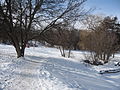 Trans Canada Trail in winter in Peterborough, Ontario
 -
![Former railway line (CN)[24] converted to the Trans Canada Trail, Saint-Prosper-de-Champlain Bridge, Quebec](//upload.wikimedia.org/wikipedia/commons/thumb/9/96/Pont_Saint_Prosper_de_Champlain_001.jpg/120px-Pont_Saint_Prosper_de_Champlain_001.jpg) Former railway line (CN)[24] converted to the Trans Canada Trail, Saint-Prosper-de-Champlain Bridge, Quebec
Former railway line (CN)[24] converted to the Trans Canada Trail, Saint-Prosper-de-Champlain Bridge, Quebec -
 Trans Canada Trail pavilion inFredericton, New Brunswick


![Former railway line (CN)[24] converted to the Trans Canada Trail, Saint-Prosper-de-Champlain Bridge, Quebec](/File:Pont_Saint_Prosper_de_Champlain_001.jpg)

See also
References
- ^ "Trans-Canada Trail rebrands, seeks to connect Canadians". marketingmag.ca. September 22, 2016. Retrieved May 7, 2019.
- ^ "Say Hello to Your New Trans Canada Trail!". tctrail.ca. June 1, 2021. Retrieved June 11, 2021.
- ^ "Trans Canada Trail". Trans Canada Trail. Retrieved June 24, 2021.
- ^ "Annual Report 2016–17" (PDF). Trans Canada Trail. 2017. p. 6. Retrieved January 28, 2018.
- ^ Trans Canada Trail: The 18,000 kilometre dream, second edition, 2006
- ^ a b c "Trans Canada Trail | Explore the Map". May 19, 2016.
- ^ "The Government of Canada invests $30M to enhance and maintain The Great Trail". newswire.ca. September 4, 2018. Retrieved May 7, 2019.
- ^ a b c "Shattered Dream:The Trans Canada Trail has become a dangerous hoax". albertaviews.ca. May 1, 2017. Retrieved August 21, 2019.
- ^ Markusoff, Jason. How the dream of the Trans Canada Trail soars—and falls short. Maclean's Magazine, September 3, 2017
- ^ Trans Canada Trail (May 25, 2017). "Trans Canada Trail Partnership". Retrieved February 26, 2018.
- ^ "Ontario Expanding Trails in Time for the". news.ontario.ca. Retrieved June 21, 2020.
- ^ Markusoff, Jason (September 3, 2017). "How the dream of the Trans Canada Trail soars—and falls short". Maclean's. Retrieved January 22, 2024.
- ^ Aunger, Edmund A. (July 2, 2014). "Trans Canada Trail has lost its way in Alberta". Calgary Herald. Retrieved January 22, 2024.
- ^ Labine, Jeff (June 28, 2018). "$4.5M pedestrian bridge en route". Fort Saskatchewan Record. Retrieved April 8, 2020.
- ^ "Fort Saskatchewan Hub of the Trans Canada Trail". FortSaskOnline.com. Retrieved April 8, 2020.
- ^ "January/February 2018 | The Great Trail". Canadian Geographic. Retrieved April 20, 2021.
- ^ "Katannilik Territorial Park | Travel Nunavut". Retrieved April 20, 2021.
- ^ "Lake Superior Water Trail | Lake Superior Watershed Conservancy". The LSWC Website. Retrieved April 20, 2021.
- ^ Edmonton, City of (April 19, 2021). "River Valley Parks". www.edmonton.ca. Retrieved April 20, 2021.
- ^ "Home Page - The Bateman Foundation - Robert Bateman". The Bateman Foundation. Retrieved April 20, 2021.
- ^ "Join us for Nature Sketch on The Great Trail!". Trans Canada Trail. August 16, 2019. Retrieved June 24, 2021.
- ^ "More than 300 Canadians embrace creativity in the great outdoors". TC Trail. October 17, 2019. Retrieved April 20, 2021.
- ^ Janet Smith, "Dianne Whelan's 500 Days in the Wild captures her epic trek along 24,000-kilometre Trans Canada Trail". Stir, November 29, 2023.
- ^ "A Century of Our Stories 1919–2019". Canadian National Railway (CN). 2019. p. 300. Retrieved October 6, 2023.