
Trashigang
Trashigang
UTC+6 (BTT ) |
|---|
Trashigang (
The town lies to the east side of the valley above the
History
Administrative
Trashigang is the largest district in Bhutan and serves as the administrative seat for the Dzongkhag and a home for the monk body.[1] It has three sub-districts and fifteen gewogs, which include Bartsham, Bidung, Kanglung, Kangpara, Khaling, Lumang, Merak, Phongmey, Radhi, Sakteng, Samkhar, Shongphu, Thrimshing, Udzorong, and Yangneer.[1] Sherubtse College was the first accredited college in Bhutan, founded in 1966 by a group of Jesuits under the leadership of William Mackey. As of 2003, it became part of the newly created Royal University of Bhutan system that comprises all public post-secondary schools in Bhutan.
Rangjung, Kanglung and Wamrong are some of the major towns under Trashigang district.
Demography
The population of Trashigang town was 3,037 (1,565 males and 1,472 females) according to the 2017 Population and Housing Census of Bhutan.[4]
Transport
Trashigang is served by Yonphula Airport which is around an hour drive from the town.[5] It is connected by Simtokha Trashigang Primary National highway to capital city. Thimphu and Trashigang Samdrup Jongkhar Highway to Samdrup Jongkhar, border town in south eastern Bhutan.
Climate
Trashigang features a dry-winter subtropical highland climate (Köppen Cwb).
| Climate data for Trashigang, 1996–2018 | |||||||||||||
|---|---|---|---|---|---|---|---|---|---|---|---|---|---|
| Month | Jan | Feb | Mar | Apr | May | Jun | Jul | Aug | Sep | Oct | Nov | Dec | Year |
| Mean daily maximum °C (°F) | 15.1 (59.2) |
17.2 (63.0) |
20.4 (68.7) |
22.7 (72.9) |
24.3 (75.7) |
25.5 (77.9) |
25.6 (78.1) |
25.9 (78.6) |
25.3 (77.5) |
23.3 (73.9) |
19.9 (67.8) |
16.9 (62.4) |
21.8 (71.3) |
| Mean daily minimum °C (°F) | 3.1 (37.6) |
4.8 (40.6) |
7.7 (45.9) |
10.5 (50.9) |
13.2 (55.8) |
15.9 (60.6) |
16.6 (61.9) |
16.4 (61.5) |
15.3 (59.5) |
11.5 (52.7) |
7.5 (45.5) |
4.6 (40.3) |
10.6 (51.1) |
| Average precipitation mm (inches) | 9.5 (0.37) |
20.4 (0.80) |
50.5 (1.99) |
105.5 (4.15) |
118.8 (4.68) |
189.2 (7.45) |
243.8 (9.60) |
204.1 (8.04) |
123.0 (4.84) |
75.3 (2.96) |
4.6 (0.18) |
4.7 (0.19) |
1,149.4 (45.25) |
| Average precipitation days (≥ 0.1 mm) | 1.6 | 3.1 | 7.4 | 11.3 | 12.3 | 15.7 | 22.1 | 20.6 | 12.0 | 5.0 | 1.1 | 1.1 | 113.3 |
| Source: World Meteorological Organization[6] | |||||||||||||
Gallery
-
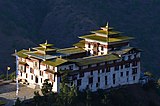 Trashigang Dzong (2011)
 -
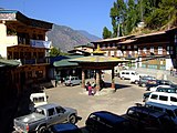 Town center, Trashigang, Bhutan (2008)
 -
 District court, Trashigang, Bhutan
 -
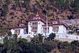
 TrashigangDzong(2008)
 -
 Trashigang Chagzam bridge


See also
References
- ^ a b c Facts about Bhutan The Land of the Thunder Dragon. Absolute Bhutan Books. 2017.
- ^ Rinzin, Yangchen C (2011-10-29). "A Fortress That's About to Fall". Kuensel online. Retrieved 2011-10-29.
- ^ "Tourism Council of Bhutan - Festival Dates 2012" (PDF). Tourism Council of Bhutan online. Retrieved 2012-12-17.
- ^ "National Statistics Bureau". Retrieved 16 April 2022.
- ^ "Drukair Domestic Flights to Bumthang & Yonphula".
- ^ "World Weather Information Service – Trashigang". World Meteorological Organization. Retrieved November 1, 2022.
External links
 Trashigang travel guide from Wikivoyage
- Trashigang and Dzong, Bhutan - Photo Gallery | The India Info
This Bhutan location article is a stub. You can help Wikipedia by expanding it. |