
Treasure Island, San Francisco
Treasure Island
Magic Isle ZIP code | 94130 | |
|---|---|---|
| Area codes | 415/628 | |
| GNIS feature IDs[5] | 236528 (island) 2624152 (Building 157) 2506912 (Job Corps Ctr) | |
| Wikimedia Commons | Treasure Island, California | |
| Website | Treasure Island Development Authority | |
| Reference no. | 987[6] | |
Treasure Island is an
Geography
The San Francisco census tract that includes Treasure Island extends up and down the San Francisco Bay and includes a small uninhabited tip of western Alameda Island.[8] Yerba Buena and Treasure islands together have a land area[verification needed] of 576.7 acres (233.4 ha) with – in 2010 – a total population of 2,500.[9] Treasure Island alone is 393 acres. It is connected by a 900 ft (270 m) causeway to Yerba Buena Island, which in turn has on- and off-ramps to Interstate 80 on the San Francisco–Oakland Bay Bridge.
The island has a marina and a bikeway connecting to the newly completed
History
Prior to the island's construction by the
| External media | |
|---|---|
| Images | |
| Video | |
On February 18, 1939, the 'Magic City'
A couplet from the song "
Military base

Treasure Island was originally intended to become a second airport for San Francisco, augmenting the existing San Francisco Municipal Airport, now SFO. But with war looming, the Navy moved in.
NAVSTA Treasure Island had a Naval Auxiliary Air Facility[5] in order to support helicopters, fixed wing planes, seaplanes, blimps, dirigibles and airships and a U.S.Navy/USMC electronics school. During World War II over 12,000 men a day were processed here for Pacific area assignments, and thousands more were processed for separation in the aftermath of the war.[17] The psychiatric ward of the naval base at Treasure Island was used to study and experiment on naval sailors who were being discharged for being homosexual.[18]
Since before the 1950s, and through the 1990s (throughout both Korean & Vietnam wars) the U.S. Navy's Naval Technical Training Center (NTTC) – Treasure Island, was operational. Multiple Maintenance Skills were part of the curriculum there, including training of Electronic Technicians (ET) in Radiation and Detection equipment (RADIAC), Communications & Radar systems, as well as training of Shipfitter and Damage Control Technicians, which also covered Nuclear Biological & Chemical (NBC) Warfare Decontamination (DECON) techniques. In 1972 a new U.S. Navy Rate consisting of the old Shipfitter and Damage Control Technician ratings was created. This New U.S. Navy Rate was Hull Maintenance Technician (HT). The Navy later realized that Damage Control is such a large responsibility, it needed a rating specifically tasked with those duties, hence the reemergence of the Damage Controlman Rating in 1988.[19]
In recognition of his naval base leadership and development efforts since the inception of US
The station was identified by the 1991 Base Realignment and Closure Commission, and NAVSTA Treasure Island closed in 1997. Remaining military structures included Bldg. 600 @ 750 Avenue M (former Naval Firefighting School, now SFFD's Treasure Island Training Facility & Temporary SFFD Fire Station 48), Bldg. 157 (Navy Fire station 2 built circa 1942 wood-frame building which lacks modern earthquake Seismic retrofit) @ 849 Avenue D (SFFD Station 48 closed March 7, 2014, due to health hazards & excessive deferred maintenance), and the 20,000 sq ft (1,900 m2) Bldg. 180 by US Naval Station Way & California Ave (now a winery).[20]
SAC radar station
The Treasure Island

Film stages and settings
From the late 1980s, Treasure Island's old aircraft Hangar 2 (Building 2) and Hangar 3 (Building 3) served as
Remediation and redevelopment
Cleanup crews spent several weeks cleaning the island's coast from the 2007
By December 2010, Navy contractors had removed 16,000 cubic yards (12,000 m3) of contaminated dirt from the site, "some with radiation levels 400 times the Environmental Protection Agency’s human exposure limits for topsoil."[33] The contaminated dirt is to be replaced by dirt removed during construction of the fourth Caldecott Tunnel bore.[34] In April 2013, caesium-137 levels three times higher than previously[when?] recorded were found (the island hosted "radioactive ships from Bikini Atoll atomic tests and [was] a major education center training personnel for nuclear war"[35]—the USS Pandemonium (PCDC-1)[36] mockup had begun nuclear training in 1957.[37][38]
Education
The island is a part of the
SFUSD previously operated Treasure Island
Gallery
-
 Looking north towards the Marin Headlands from the western shore.
 -
 Looking south towards Yerba Buena Island and the Bay Bridge from the western shore.
 -
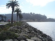
 Treasure Island Marina on the island's south shore
 -
 The bridge's new eastern span is best viewed from near the marina
 -
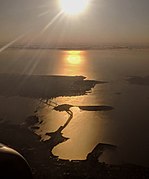 The San Francisco–Oakland Bay Bridge, Yerba Buena Island, Treasure Island, and San Francisco, in an afternoon aerial view looking into the sun


See also
References
- ^ a b c d McGloin, John Bernard. "Symphonies in Steel: Bay Bridge and the Golden Gate". The Virtual Museum of the City of San Francisco (SFmuseum.net). Retrieved October 22, 2013.
The Secretary of War approved the request that its execution be undertaken by the Army Corps of Engineers. While a group of such specialists applied their talents to the reclamation of the 'Yerba Buena Shoals', the day-by-day details were efficiently cared for by Colonel Fred Butler, U.S.A., who had years of army engineering experience behind him at this time. The fill to form Treasure Island was obtained by dredging operations; the island covered an area of 400 acres [160 ha], 5,520 feet [1,680 m] long by 3,410 feet [1,040 m] wide.
- ^ a b "Statewide Database". UC Regents. Retrieved November 5, 2014.
- ^ "California's 11th Congressional District - Representatives & District Map". Civic Impulse, LLC.
- ^ a b "94130 Zip Code (San Francisco, California) Profile: homes, apartments, schools, population, income, averages, housing, demographics, location, statistics, sex offenders, residents and real estate info". City-data.com. Retrieved November 7, 2012.
- ^ a b c * "Treasure Island (236528)". Geographic Names Information System. United States Geological Survey, United States Department of the Interior. Retrieved October 25, 2013. "374929N 1222216W...374937N 1222241W"
- "San Francisco Fire Department Station 48 Treasure Island (2624152)". Geographic Names Information System. United States Geological Survey, United States Department of the Interior. Retrieved October 25, 2013. "Building 157...374931N 1222226W"
- "Treasure Island Job Corps Center (2506912)". Geographic Names Information System. United States Geological Survey, United States Department of the Interior. Retrieved October 25, 2013.
655 Avenue H
- "Naval Station Treasure Island (historical)". Geographic Names Information System. United States Geological Survey, United States Department of the Interior. Retrieved October 25, 2013.
- "Treasure Island Naval Auxiliary Air Facility (historical) (1988803)". Geographic Names Information System. United States Geological Survey, United States Department of the Interior. Retrieved October 25, 2013.
- ^ a b c Office of Historic Preservation. "San Francisco". California Historical Landmarks. California Department of Parks and Recreation. Retrieved October 26, 2013.
- ISBN 9781467106160.
- ^ "San Francisco Census Tract Outline Map" (PDF) (Map). Census 2000. United States Census Bureau. Retrieved December 16, 2013.
- United States Census, 2010[full citation needed]
- ^ a b c Workers of the Federal Writers’ Project (1938). "Trail Ends for '39ers". Almanac for Thirty-Niners. San Francisco Works Progress Administration – via SFmuseum.net.
- ^ James, Jack; Weller, Earle Vonard (1941). Treasure island, "The Magic City," 1939-1940; The Story of the Golden Gate International Exposition. Pisani printing and publishing company. Retrieved August 22, 2021.
- ^ "San Francisco Attractions". SF-Attractions.
- ^ a b "Treasure Isle Goes to Navy: City Upset Over Offer, May Dispute Price". The San Francisco News. April 17, 1942. Retrieved October 26, 2013 – via SFmuseum.net.
- ^ "Treasure Island Accord". The Virtual Museum of the City of San Francisco.
- ^ Flynn, William (1954). Men, Money and Mud – The Story of San Francisco International Airport. W. Flynn Publications. p. 37.
- ^ Hice, Eric; Schierling, Daniel (1996). Historical Study of Yerba Buena Island, Treasure Island, and their Buildings. pp. 2–17.
- ^ Lemon, Sue. "Treasure Island, Naval Station, 1937 - ." United States Navy and Marine Corps Bases, Domestic. Paolo E. Coletta, Editor. Westport, CT: Greenwood, 1985.
- ISBN 0-8118-1187-5.
- ^ "DEV Charlie Marine Air Support Radar Team". The Korean War Project.
- ^ "The Winery SF". Retrieved December 2, 2010.
- ^ Tim in San Mateo (October 2, 2002). "San Francisco Bomb Plot". Yahoo! Groups. Self-published via Yahoo!. Archived from the original on October 28, 2013. Retrieved October 25, 2013.
- ^ Martin, Jack S. (September 23, 1949). Report of Investigation: Project Grudge (Special Inquiry). Fairfield-Suisun Air Force Base: USAF Office of Special Investigations. Retrieved October 26, 2013.
On 14 September 1949, Captain Howard A. Carlson,12456-A/ Detachment Commander, Detachment B, 3903 Radar Bomb Scoring Squadron, Treasure Island, San Francisco, California, was interviewed and stated that on 1 August 1949, two radar testing devices were released; one at approximately 1000 hours, PST, and another at 1400 hours, PST.
- ^ a b "Home". Treasure Island Museum Association. Retrieved July 20, 2008.
- ^ "The Museum and Its Collection". Treasure Island Museum Association. Retrieved December 16, 2013.
- ^ SF filming locations for Nash Bridges
- ^ "'Mythbusters' Tackles Titanic Debate". CBS News. October 9, 2012. Retrieved July 22, 2020.
- ^ Marek, Grant (September 28, 2019). "How Treasure Island found its way into the most iconic Indiana Jones film". SFGate. Retrieved July 22, 2020.
- ^ John Cote, "City to get Treasure Island for $105 million." SF Gate, December 17, 2009
- ^ Kane, Will (June 8, 2011). "S.F. approves Treasure Island plan". The San Francisco Chronicle. Retrieved December 7, 2012.
- ^ "Treasure Island: Development Project". Treasure Island Development Authority. Retrieved October 11, 2012.
- ^ "Power Outages On Treasure Island In San Francisco". Power Outages On Treasure Island In San Francisco.
- ^ Fagone and Dizikes (September 10, 2019). "Treasure Island ferry terminal breaks ground in anticipation of 8,000 new SF homes". San Francisco Chronicle. Retrieved September 19, 2019.
- ^ Matt Smith (August 17, 2012). "Radiation Contamination on Treasure Island More Widespread Than Reported". The Bay Citizen.
- ^ Cuff, Denis (November 13, 2013). "Caldecott Tunnel forth bore to ease traffic backups during reverse commute". Mercury News. Retrieved December 29, 2018.
- ^ Smith, Matt; Mierskowski, Katherine (April 12, 2013). "Soil tests find cesium, linked to cancer risk, up to 3 times higher than previously acknowledged". The Bay Citizen. Retrieved October 26, 2013.
Until the early 1990s, the Navy operated atomic warfare training academies on Treasure Island, using instruction materials and devices that included radioactive plutonium, cesium, tritium, cadmium, strontium, krypton and cobalt. These supplies were stored at various locations around the former base, including supply depots, classrooms and vaults, and in and around a mocked-up atomic warfare training ship—the USS Pandemonium.
- ^ The Sandusky Register on. Newspapers.com (1957-03-21). Retrieved on 2014-05-10.
- ^ Ron Russell (May 24, 2006). "Toxic Acres: The fill below Treasure Island is filled with dangerous toxins left by the Navy". SF Weekly. Retrieved July 2, 2017.
- ^ Ashley Bates, "Radioactive Isle." East Bay Express, September 9, 2012
- ^ "Final Recommendations for Elementary Attendance Areas Prepared for September 28, 2010 Board Meeting." San Francisco Unified School District. Retrieved on April 18, 2018.
- ^ Knight, Heather (December 6, 2005). "SAN FRANCISCO / Board votes to close Treasure Island school". San Francisco Chronicle. Retrieved January 1, 2017.
Further reading
- Katie Canales (December 16, 2019). "San Francisco's housing market is so dire that the city's radioactive Treasure Island is finally getting a $6 billion makeover. Meet the residents who have lived on it for years". Business Insider.
External links
 Media related to Treasure Island, San Francisco at Wikimedia Commons
- Treasure Island Music Festival
- Treasure Island School at the Wayback Machine (archive index)
| |

| Downtown |  | |
|---|---|---|
| North of Downtown | ||
| Outside Lands | ||
| Western Addition | ||
| Southern | ||
| International | |
|---|---|
| National | |
| Geographic | |
| Other | |