
Trethevy Quoit
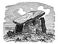
 Trethevy Quoit viewed from the northwest | |
 Shown within Cornwall | |
| Location | St Cleer, Cornwall |
|---|---|
| Coordinates | 50°29′35″N 4°27′20″W / 50.4931814°N 4.4554281°W |
| Type | Dolmen |
| History | |
| Periods | Neolithic |
| Site notes | |
| Ownership | Cornwall Heritage Trust |
| Public access | Yes |
| Official name | Trethevy Quoit |
| Designated | 10 August 1923 |
| Reference no. | 1017579 |
Trethevy Quoit (
Location
Trethevy Quoit is north of Liskeard in the hamlet of Tremar Coombe. Nearby Trethevy farmhouse is a Grade II* listed building.[3] Nearby are The Hurlers, three stone circles dating from the late Bronze Age. The site is owned and managed by the Cornwall Heritage Trust on behalf of English Heritage.[4]
Construction
Like other portal structures of this type, Trethevy Quoit was originally covered by a mound. The remnants of this suggest a diameter of 6.5 metres (21 ft). The remaining seven stones and the 3.7-metre (12 ft) long and 10.5-ton cover slab were inside the mound. At the upper end of the cover slab is a natural hole, which may have been used for astronomical observation. The group of horizontal stones is composed of a fallen back wall, two overlapping side wall stones, a front stone and a somewhat remote flanking stone. The special feature of Cornish portal graves is that by such stones sometimes a smaller partially closed area is created before the front end. Some stones have hole-like perforations as decoration. The front stone is often called an entrance stone, although in most portal structures this can not be moved. Trevethy Quoit is a rare exception here, because a small rectangular stone moving at the bottom right of the front allows access to the chamber, which is now opened only very rarely.
The back of the chamber has collapsed inwards and now forms a pile inside the chamber. Erect, this stone would be about the height of the front stone, so that the cover slab would not have once been held up by the side stones, but rested almost horizontal solely on the front stone and rear walls. However, there would have been a considerable gap between the support stones and the side walls, by which soil could have penetrated into the chamber. It is therefore likely that the collapse of the rear wall and the falling of the cover slab damaged the side stones. In November 2017 the quoit was added to Historic England's Heritage at Risk Register, because of damage caused by fencing and increasing erosion by livestock.[5]
Studies
Trethevy Quoit was first mentioned in 1584 by
-
 Etching by W. C. Borlase 1872
 -
 East side of Trethevy Quoit
 -
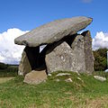 The quoit from the south


References
- ^ Place-names in the Standard Written Form (SWF) Archived 2013-05-15 at the Wayback Machine : List of place-names agreed by the MAGA Signage Panel Archived 2013-05-15 at the Wayback Machine. Cornish Language Partnership.
- ASIN B0055PQCH0.
- ^ Historic England. "Trethevy Farmhouse (Grade II*) (1159487)". National Heritage List for England. Retrieved 30 November 2021.
- ^ "Trethevy Quoit: a burial chamber from the late Neolithic period". Cornwall Heritage Trust. Retrieved 24 June 2018.
- ^ Matthews, Chris (2 November 2017). "Trethevy Quoit put on heritage 'at risk' register". The Cornishman. p. 26.
- ^ Norden, John (1728). Speculi Britanniæ Pars: a topographical and chorographical description of Cornwall. London: C. Bateman.
- ^ Borlase, William Copeland (1872). Naenia Cornubiae. London: Longmans.
- ^ Hencken, Hugh O'Neill (1932). The Archaeology of Cornwall and Scilly. London: Methuen.
- ISBN 0855001291.