
Trincomalee
Trincomalee
திருகோணமலை ත්රිකුණාමලය | |
|---|---|
UTC+6 |
Trincomalee (English:
Trincomalee was made into a fortified port town following the Portuguese conquest of the Jaffna kingdom, changing hands between the Danish in 1620, the Dutch, the French following a battle of the American Revolutionary War and the British in 1795, being absorbed into the British Ceylon state in 1815. The city's architecture shows some of the best examples of interaction between native and European styles. Attacked by the Japanese as part of the Indian Ocean raid during World War II in 1942, the city and district were affected after Sri Lanka gained independence in 1948, when the political relationship between Tamil and Sinhalese people deteriorated, erupting into civil war. It is home to major naval and air force bases at the Trincomalee Garrison. The city also has the largest Dutch fort on the island.
The
Names and etymology
Trincomalee
The city has developed from a village settlement on the promontory dedicated to the
Gokarna Bay, Trincomalee
The
on this connection.[13]
The ethnographer
Kailaas of the South
Heralded as "Dakshina Kailasam"/"Then Kailasam" (Kailaas of the South) because it lies on exactly the same longitude as the
As per another legend, Vayu Bhaghvan and Adiseshan had a dispute to find out who is superior, to prove the superiority adiseshan encircled the Kailasam, Vayu tried to remove this encircle by creating santamarutham (Twister). Due to the santamarutham, eight (8) kodumudigal (parts) fell from kailasam into 8 different places: are Thirugonamalai (Trincomalee), Thirukalahasti, Thiruchiramalai, Thiruenkoimalai, Rajathagiri, Neerthagiri, Ratnagiri, and Suwethagiri Thirupangeeli.[26]
History
This section may be too long to read and navigate comfortably. (January 2017) |
Earliest history


Trincomalee which is a natural deep-water harbour has attracted seafarers, trader and pilgrims from
Ancient texts, as well as an inscription unearthed by archeologists among its
In the earliest known literary reference to the Siva temple,
The Siva-worshipping Siddhar Patanjali's birth at the city in 180 BCE and its connections to another Siddhar Agastya from at least the 5th–4th century BCE suggests that Yoga Sun Salutation originated on the promontory of Trincomalee.[18][36][37][38] One of Trincomalee's suburbs, Kankuveli is home to ruins of the Tamil Siddhar medical university established by Agastya, the "Agathiyar Thapanam", which alongside his other shrines at Sivan Oli Padam Malai, helped spread Tamraparniyan science across the continent during the pre-classical era.[39][37] The Vayu Purana refers to the Siva temple on Trikuta hill on the eastern coast of Lanka once again in the 3rd century.[14]
Another mention is found in the 5th century CE
Middle Ages
Early Tamil dynasties continued to employ the city as the prefectural capital of the
Following the conquest of
The Koneswaram temple compounds, the city and its adjacent region, from Periyakulam and Manankerni in the north,
Magha's reign ousted Parakrama Pandyan II and re-consolidated Tamil sovereign power in the island's north, north west and north east in Trincomalee by 1215; during Magha's reign, the temple and city underwent rich development in the name of a Chodaganga Deva on Puthandu, 1223.[15] After the fall of the Pandyans of Tamilakam due to invasions by Muhammad bin Tughluq of the Delhi Sultanate, Trincomalee rose in status in the Jaffna kingdom, often visited by King Singai Pararasasegaram and his successor King Cankili I in the following centuries.[54]
Trincomalee served a similar purpose to its west coast sister city,
By the late 16th century,
The Trincomalee and Batticaloa chiefdoms starting paying direct tributes to the Portuguese commander in Mannar from 1582 as Portuguese influence over the entire North east gained momentum. An annual sum of 1280 fanams was levied from the Koneswaram temple, and they collected a duty on areca nuts exported through the Trincomalee and Batticaloa ports.[63] Jaffna had given minimal logistical access to its Trincomalee and Batticaloa seaports to the Kandyan kingdom to secure military advantages against its enemies; this was used by their influential European overlords to consolidate power in the region. In 1603, the first Dutch fleet arrives at Trincomalee and Batticaloa ports.[64]
In 1612, D. Hieronymo de Azevedo, after great difficulties due to torrential rains, arrived at Trincomalee with a Portuguese contingent from Kandy. Here de Azevedo "was keen on building a fort" to the scope; he called in aid from King Ethirimana Cinkam of Jaffna but not seeing him, he abandoned the enterprise and he marched towards Jaffna.[65][66] The early death of Cankili I brought upon by the Portuguese conquest of the Jaffna kingdom saw all the territory of the kingdom of Jaffna, comprising both Trincomalee and Batticaloa, assigned to the "spiritual cures of the Franciscans". The Jesuits followed the Portuguese soldiers to Trincomalee and Batticaloa when they occupied the two localities.[65][66][67]
Early modern


The buildings of Trincomalee were of masonry, thatched with leaves of bamboo and rattan, although the Pagodas and the Palace of the King were covered with copper, silver and gold. The metropolis had grown with well-built houses and streets that were cleaned regularly and were well adorned. The
Following the destruction of the Koneswaram compound and the Fort of Triquinimale built from its ruins, Trincomalee had a Portuguese force during the reign of
The city had rejoined the Coylot Vanni Country by the start of the 18th century, with much of the city's population having moved across the district following the temple's destruction.
Late modern and contemporary

Jacob Burnand, a Swiss soldier in the service of the Dutch and the Governor of Batticaloa, composed a memoir on his administration there in 1794, noting Trincomalee to be an important fortified town in the Tamil nation.[72] Trincomalee's fort was occupied by the Dutch for most of the 18th century, and subsequently by the French who fought and won the Battle of Trincomalee as part of the American Revolutionary War in 1782 at the city.[73]
On 8 January 1782, the
The ship HMS Trincomalee was built during the early 19th century by Indian workers to aid them in the Napoleonic Wars, and named after the city. The importance of Fort Fredrick was due to Trincomalee's natural harbour. Through Trincomalee, it was believed a strong naval force could secure control of India's Coromandel Coast and the rest of the Indian Ocean. The British admiral Horatio Nelson, 1st Viscount Nelson called Trincomalee "the finest harbour in the world", while the British Prime Minister William Pitt the Younger called the city "the most valuable colonial possession on the globe, as giving to our Indian Empire a security which it had not enjoyed from its establishment" and the harbour "the finest and most advantageous Bay in the whole of India". In the 19th century, the Trincomali Channel of British Columbia, Canada was built and named after the city's name.[75] A Tamil press is established in Jaffna in 1820; a report on Trincomalee laments its sorry, poverty-stricken state and recommends 'colonization with intelligent settlers'. By 1827, The Return of the Population 1824 is published, giving the total population figures for Trincomalee as 19,158 – Tamils and among them 317 Sinhalese. The Vanni, counted under Mannar, has 22,536 inhabitants, among them 517 Sinhalese.[citation needed]
Before the
One of the places inhabited by the British was Fort Fredrick, now controlled by the
With the turn of the modern era, English authors and poets used Trincomalee as inspiration for literature and poetry and became connected with the city. Arthur C. Clarke, who discovered the temple's underwater ruins with photographer Mike Wilson, described the city and the ruins in Reefs of Taprobane and would go on to write 2001: A Space Odyssey based on his experiences in the city. Trincomalee's Bhadrakali Amman temple provides a setting in Wilbur Smith's novel Birds of Prey. Arthur Conan Doyle's Sherlock Holmes stories feature multiple settings in the city, including in A Scandal in Bohemia and A Singular Affair at Trincomalee. Jane Austen's younger brother, Charles, of the British Royal Navy is buried in Trincomalee.[citation needed]
Post independence
In 1950, one of the original shrine's
In the mid-1980s, India became concerned that the US Navy might gain access to Trincomalee. India was suspicious about goodwill visits by the US Navy to the port and Sri Lankan proposals to contract out the refurbishment of oil storage tanks and modernisation of port facilities at Trincomalee.[82] On March 3, 2023, President Ranil Wickremesinghe instructed the petroleum minister and officials to promptly implement a strategy to revitalize the Trincomalee oil tank farm and integrate it into the nation's economy.[83]
Today SLNS Tissa and SLN Dockyard are used by the
In the aftermath of the 2004 Indian Ocean earthquake and tsunami, Trincomalee was a focal point for relief efforts on the eastern coast of Sri Lanka.[84]
Historical sites


Trincomalee is sacred to
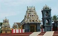
Prominent sites include the Koneswaram temple compound, its Bhadrakali temple on Konesar Road, and the Salli Muthumariamman Kovil of Uppuveli beach in the Trincomalee suburb of Sambalativu.[8]
Hindu historical sites
The Koneswaram temple, with a recorded history from the 3rd century BCE and legends attesting to classical antiquity attracted pilgrims from all parts of India. The shrine itself was demolished in 1622 by the Portuguese (who called it the Temple of a Thousand Columns), and who fortified the heights with the materials derived from its destruction. Some of the artifacts from the demolished temple were kept in the Lisbon Museum including the stone inscription by Kulakottan (Kunakottan). The site's ruins include an emblem including two fish and is engraved with a prophecy stating that, after the 16th century, westerners with different eye colours will rule the country for 500 years and, at the end of it, rule will revert to the northerners (Vadukkus. The Hindu temple was also documented in several medieval texts such as the Konesar Kalvettu[13] and the Dakshina Kailasa Puranam.[85]
The Dutch Fort
The entrance to the roadway leading to Koneswaram is actually the entrance to what used to be Fort Fredrick. The fort was built in 1623 by the Portuguese and captured in 1639 by the Dutch. It then went through a phase of dismantling and reconstruction and was attacked and captured by the British in 1782, during the Fourth Anglo-Dutch War. The French then took it from the British, and handed it back to the Dutch for a large sum of money. In 1795, when the French had occupied the Dutch Republic during the War of the First Coalition, it was again taken over by the British, who named it Fort Frederick.[86]
Harbour
Trincomalee's strategic importance has shaped its recent history. The great European powers vied for mastery of the harbour. The Portuguese, the Dutch, the French, and the British, each held it in turn, and there have been many sea battles nearby.
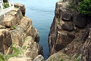
The harbour, the fifth largest natural harbour in the world, is overlooked by terraced highlands, its entrance is guarded by two headlands, and there is a carriage road along its northern and eastern edges.
Oil depot
In 2015, India and Sri Lanka agreed to develop South Asia's largest oil depot at a port near Trincomalee. Indian Oil Corporation will work with the Ceylon Petroleum Corporation to develop the Upper Tank Farm at the abandoned World War II port, known as China Bay.[87]
Beaches

Trincomalee has some of the most picturesque and scenic beaches found in Sri Lanka, relatively unspoilt and clean. The area is famous for bathing and swimming, owing to the relative shallowness of the sea, allowing one to walk out over a hundred meters into the sea without the water reaching the chest. Whale watching is a common pastime in the seas off Trincomalee, and successful sightings are on the rise with the increase of tourism in the area.[88]
Marble Beach is located in 16 km (10 miles) from Trincomalee.[89]
Hot springs
There are the seven
Climate
Trincomalee features a
| Climate data for Trincomalee (1991–2020 normals) | |||||||||||||
|---|---|---|---|---|---|---|---|---|---|---|---|---|---|
| Month | Jan | Feb | Mar | Apr | May | Jun | Jul | Aug | Sep | Oct | Nov | Dec | Year |
| Record high °C (°F) | 34.8 (94.6) |
35.4 (95.7) |
39.2 (102.6) |
39.0 (102.2) |
39.8 (103.6) |
39.5 (103.1) |
39.0 (102.2) |
39.4 (102.9) |
39.5 (103.1) |
38.7 (101.7) |
36.2 (97.2) |
33.4 (92.1) |
39.8 (103.6) |
| Mean daily maximum °C (°F) | 28.9 (84.0) |
30.1 (86.2) |
31.7 (89.1) |
33.4 (92.1) |
35.2 (95.4) |
35.4 (95.7) |
35.3 (95.5) |
35.3 (95.5) |
34.8 (94.6) |
32.4 (90.3) |
29.8 (85.6) |
28.8 (83.8) |
32.6 (90.7) |
| Daily mean °C (°F) | 26.5 (79.7) |
27.2 (81.0) |
28.2 (82.8) |
29.5 (85.1) |
30.6 (87.1) |
30.9 (87.6) |
30.6 (87.1) |
30.3 (86.5) |
30.1 (86.2) |
28.5 (83.3) |
26.9 (80.4) |
26.3 (79.3) |
28.8 (83.8) |
| Mean daily minimum °C (°F) | 24.0 (75.2) |
24.3 (75.7) |
24.8 (76.6) |
25.5 (77.9) |
26.2 (79.2) |
26.3 (79.3) |
25.8 (78.4) |
25.5 (77.9) |
25.1 (77.2) |
24.5 (76.1) |
24.0 (75.2) |
23.8 (74.8) |
25.0 (77.0) |
| Record low °C (°F) | 18.5 (65.3) |
18.2 (64.8) |
19.5 (67.1) |
19.0 (66.2) |
19.1 (66.4) |
20.6 (69.1) |
21.2 (70.2) |
20.2 (68.4) |
18.7 (65.7) |
18.7 (65.7) |
18.7 (65.7) |
16.5 (61.7) |
16.5 (61.7) |
| Average precipitation mm (inches) | 152.4 (6.00) |
96.1 (3.78) |
71.8 (2.83) |
54.8 (2.16) |
48.1 (1.89) |
25.9 (1.02) |
51.0 (2.01) |
66.6 (2.62) |
112.6 (4.43) |
215.6 (8.49) |
375.6 (14.79) |
339.0 (13.35) |
1,609.3 (63.36) |
| Average precipitation days (≥ 1.0 mm) | 8.4 | 4.7 | 4.0 | 4.2 | 4.2 | 1.9 | 3.4 | 4.2 | 5.7 | 12.8 | 17.9 | 15.0 | 86.3 |
| Average relative humidity (%) (at Daytime)
|
75 | 72 | 71 | 70 | 64 | 58 | 60 | 61 | 63 | 71 | 78 | 80 | 69 |
| Mean monthly sunshine hours | 257.3 | 268.4 | 300.7 | 279.0 | 263.5 | 231.0 | 235.6 | 244.9 | 207.0 | 217.0 | 171.0 | 167.4 | 2,842.8 |
| Mean daily sunshine hours | 8.3 | 9.5 | 9.7 | 9.3 | 8.5 | 7.7 | 7.6 | 7.9 | 6.9 | 7.0 | 5.7 | 5.4 | 7.8 |
| Source 1: NOAA (humidity 1961–1990)[91][92] | |||||||||||||
| Source 2: Deutscher Wetterdienst (precipitation days, 1968–1990 and sun, 1975–1983),[93] Department of Meteorology (records up to 2007)[90] | |||||||||||||
Transport and communications
Road and rail
Trincomalee is on the eastern end of the
The city is also served by
Broadcasting
German broadcaster
Education
The
List of schools in Trincomalee city
- Methodist Girls' College, Trincomalee
- Orr's Hill Vivekananda College
- R. K. M. Sri Koneswara Hindu College
- Sri Shanmuga Hindu Ladies College
- St. Joseph's College, Trincomalee
- St. Mary's College, Trincomalee
- Vigneshwara Maha Vidyalaya
See also
- Place names in Sri Lanka
- Sampur Coal Power Station
- HMS Trincomalee, a British sailing frigate built in India.
- Trincomalee Garrison
- Trikuta
- Arunagirinagar
References
- ^ "Trincomalee – Sri Lanka". britannica.com. Retrieved 31 March 2018.
- ^ Gunasingam, Selladurai (1979). The Tamils and Trincomalee (PDF). Jaffna: Aseeravatham Press. p. 1-30.
- ^ "Sri Lanka: largest cities and towns and statistics of their population". World Gazetteer.[dead link]
- ^ )
- ^ OCLC 12240260.
Koneswaram temple. Tiru-Kona-malai, sacred mountain of Kona or Koneser, Iswara or Siva. The date of building the original temple is given as 1580, BCE. according to a Tamil poem by Kavi Raja Virothayan translated into English in 1831 by Simon Cassie Chitty...
- OCLC 13501485.
- ISBN 978-955-1266-72-1.
- ^ OCLC 230674424.
- ISBN 0-559-29668-1.
- OCLC 439732470.
- ^ "Tirukōṇa-malai (Trincomalee), Kīri-malai, Kutirai-malai". TamilNet. 1 July 2007.
- ^ "Aayiththiyamalai". TamilNet. 24 October 2010.
- ^ a b S. Pathmanathan, The Kingdom of Jaffna, Colombo, 1978. pages 135–144
- ^ a b H.N. Apte, Vayupurana, Chapter 48 verses 20–30, Poona, 1929
- ^ Era Year 1145), and details donations this royal made to Konamamalai temple
- ISBN 978-955-1266-72-1.
- )
- ^ a b S. Vithiananthan (1980). Nān̲kāvatu An̲aittulakat Tamil̲ārāycci Makānāṭṭu nikal̲ccikaḷ, Yāl̲ppāṇam, Can̲avari, 1974, Volume 2. pp. 170
- ^ OCLC 2556531.
The Malabars call it Tirukonathamalei, or "the mountain of the sacred Konatha," from the Hindoo god of that name, who had formerly a temple on the summit of one of the hills there, which was celebrated over the whole of India...
- OCLC 2975965.
The districts at the southern extremity of Batticaloa, Pannoa and Pannaham are so called from the two Tamil words palen-nagai, the smiling babe.
- ^ )
- ^ Romesh Chunder Dutt (2001). A History of Civilisation in Ancient India: Based on Sanscrit ..., Volume 1. pp.285
- ^ Ajay Mitra Shastri (1969). India as seen in the Bṛhatsaṁhitā of Varāhamihira, pp.109. "Gonarda could be a rendering of Ko-Natha, Go-Natha, or Go-Nadu. Gonarda" (IX.13; XXXII.22), a locality in the southern division (XIV. 12) as mentioned in the Brihat-Samhita of Varāhamihira. The Markandeya Purana (LVIII.20-9) also mentions Gonarda among the countries of southern India.
- ^ Manohar Laxman Varadpande (1987). History of Indian Theatre, Volume 1, pp. 80–81
- ^ Tirupatti, Tirumalai, Jagannath and Vaijayanthi and concludes that while these latter temples were well visited by the Hindus, the former had surpassed all the latter temples.
- ^ "Arulmigu Gneelivaneswarar Temple". Archived from the original on 5 July 2018. Retrieved 6 July 2018.
- ^ S. Pathmanathan. (1978). The Kingdom of Jaffna. Volume 1. pp.136
- ^ TamilNet. "TamilNet". www.tamilnet.com. Archived from the original on 18 October 2017. Retrieved 31 March 2018.
- Nilakanta Mahadeva)
{{cite journal}}: Cite journal requires|journal=(help - Nilakanta Mahadevarat Matsyakesvaram on Konaparvatam of Tirukonamalai for conducting daily worship and rituals. Nittavinotapuram, Patiyana Aipolilpattinam, Makalana, Vikkiramacalamekapuram, Matottamana Iramakulavallip pattinam are some of the merchant towns where archaeological remains of monuments datable to the period of Chola administration have been found.
- ^ Professor K. Indrapala, Early Tamil Settlements in Ceylon. PhD Thesis, University of London, 1965.page 331
- ^ Constance Frederica Gordon Cumming (1893). Two happy years in Ceylon. pp. 295
- ^ Jonathan Forbes, George Turnour. (1840). Eleven years in Ceylon: Comprising sketches of the field sports and natural history of that colony, and an account of its history and antiquities. p. 44
- ^ Mahabharata. Volume 3. pp. 46–47
- ^ "Listen as I now recount the isle of Tamraparni, gemmed upon the ocean. The gods underwent austerities there, in a desire to attain greatness. In that region also is the lake of Gokarna. Then one should go to Gokarna, renowned in the three worlds. O Indra among kings! It is in the middle of the ocean and is worshipped by all the worlds. Brahma, the Devas, the rishis, the ascetics, the bhutas (spirits or ghosts), the yakshas, the pishachas, the kinnaras, the great nagas, the siddhas, the charanas, the gandharvas, humans, the pannagas, rivers ocean and mountains worship Uma's consort there". Mahabharata. Volume 3. pp. 46–47, 99
- OCLC 8305376.in South India to the Parameswara Shiva temple at Tirukarasai — now in ruins — on the bank of the Mavilli Gangai before worshipping at Koneswaram; from there he went to Maha Tuvaddapuri to worship Lord Ketheeswarar and finally settled down on the Podiya Hills
The Dakshina Kailasa Manmiam, a chronicle on the history of the temple, notes that the Sage Agastya proceeded from Vetharaniam
- ^ ISBN 955-9429-91-4.
Of particular importance are the references in two Sanskrit dramas of the 9th century to the abode of Agastya shrines on Sivan Oli Padam Malai called Akastiya Stapanam, Trikutakiri and Ilankaitturai in the Trincomalee District where Koneswaram is located
- ^ Academy, Himalayan. "Hinduism Today Magazine". www.hinduismtoday.com. Archived from the original on 6 May 2019. Retrieved 11 May 2019.
- ^ Mahavamsa. Chapter 35. Verses 40–47
- ^ Culavamsa: Being the More Recent Part of Mahavamsa. pp59-60
- ^ Sivaratnam, C (1964). An outline of the cultural history and principles of Hinduism (1 ed.). Colombo: Stangard Printers. OCLC 12240260. Koneswaram temple. Tiru-Kona-malai, sacred mountain of Kona or Koneser, Iswara or Siva. The date of building the original temple is given as 1580 B.C., according to a Tamil poem by Kavi Raja Virothayan translated into English in 1831 by Simon Cassie Chitty...
- ^ Ci Patmanātan, S. Pathmanathan (1978). The Kingdom of Jaffna, Volume 1. pp. 26–27
- ISBN 978-955-1266-72-1.
- )
- OCLC 249907591.
- ^ Thirunanacamptanta Cuvamikal Arulicceyta Tevarattiruppatikankal, Saiva Siddhanta publishing works Ltd, Madras, 1927
- OCLC 453189836.
The earliest mention of the shrine is in the hymns of Thirugnana sambandar who sings of "Konamamalai, and of the peerless God, who dwelled on Konamamalai, to the sound of roaring ocean, and rows of Kalal and the anklets, and half of whose body is shared by the Maid of the Mountains..."
- ^ KAN Sastri, A History of South India, p412
- ^ N. Parameswaran (2003). Medieval Tamils in Lanka = Ilankai. pp. 13
- ^ a b c Schalk, Peter (2002). "Buddhism Among Tamils in Pre-colonial Tamilakam and Ilam: Prologue. The Pre-Pallava and the Pallava period". Acta Universitatis Upsaliensis. 19–20. Uppsala University: 159, 503.
- ^ Chola-era inscriptions record the activities of Tamil mercantile communities in Padavikulam. The mercantile groups referred to were the Ticai Aayirattu Ain Nurruvar (Velupillai, Ceylon Tamil Inscriptions, 1971) and the Ayyavole. Taniyappan, a merchant from Padavikulam, laid a foundation stone for a Siva temple there. A Tamil inscription by Raja Raja Chola refers to Ravi Kulamanikkeswaram Siva Temple in Padavikulam. (K. Indrapala, Epigraphia Tamilica, Jaffna Archeological Society, 1971 – page 34). A 13th century Sanskrit inscription excavated here mentions a Brahmin village in the area. The paddy fields of Padavikulam were watered by the Per Aru river.
- ^ Abraham, Meera (1988). Two medieval merchant guilds of south India. p. 132
- OCLC 12552979.
- ^ Gnanaprakasar,A Critical History of Jaffna, p.99-102
- ^ Kunarasa,The Jaffna Dynasty, p.67-68
- ^ J R Sinnatamby (1968). Ceylon in Ptolemy's geography
- ^ Gerolamo Emilio Gerini. (1974). Researches on Ptolemy's Geography of Eastern Asia. Munshiram Manoharlal Publishers Pvt. Ltd. (reprint). Ma Huan calls the headland hill as being Ying-ko tsui Shan or Ying-Ko Tswei Shan – a hawk-beak shaped hill on the east coast
- ^ Ci Patmanātan, S. Pathmanathan (1978). The Kingdom of Jaffna, Volume 1. p. 237
- ^ Asiff Hussein (2007). Sarandib: an ethnological study of the Muslims of Sri Lanka
- ^ a b M. G. Francis. History of Ceylon: An Abridged Translation of Professor Peter Courtenay's Work. pp.80
- ^ Perniola, V. "The Catholic church in Sri Lanka. The Portuguese period", vol. II, p. 366.
- ^ Jorge Manuel Flores; Fundação Calouste Gulbenkian. (2007). Re-exploring the links : history and constructed histories between Portugal and Sri Lanka. p. 36
- ^ Robert Montgomery Martin. (1839). Statistics of the Colonies of the British Empire,... . p. 370
- ^ a b Perniola, V. "The Catholic church in Sri Lanka. The Portuguese period", vol. II
- ^ a b Perniola, V. "The Catholic church in Sri Lanka. The Portuguese period", vol. III
- ^ This decision was taken by the bishop of Cochin, Dom Sebastião de S. Pedro. Later, another decree of the same bishop dated 11 November 1622, tracing the one indicated in 1602, entrusted newly to the Jesuits the spiritual cure in the districts of Jaffna, Trincomalee and Batticaloa, giving to them possibility to build churches, to train the sacraments and to convert souls.
- ^ Barner Jensen, U. "Danish East India. Trade coins and the coins of Tranquebar, 1620–1845", pp. 11–12; Holden Furber "Imperi rivali nei mercati d’oriente, 1600–1800", note n° 66, p. 326: "Senarat of Kandy sent to Trincomalee 60 Sinhala men in order to help the Danes in the construction of their fort. During their permanence in Trincomalee, the Danesh coined also some "Larins", on which were recorded the words 'Don Erich Grubbe', of these coins, today do not remain trace, if not in the diary of Ove Giedde."
- ^ Professor Jeremy Black, Jeremy Black. From Louis XIV to Napoleon: The Fate of a Great Power. pp.1678
- ^ a b c d Alicia Schrikker. (2006). Dutch and British colonial intervention in Sri Lanka c. 1780–1815: expansion and reform. Proefschrift Universiteit Leiden. pp.86
- ^ J. Burnand helps with the suppression of the revolt against the Indian amildars, administrators brought from Madras to Ceylon. He drafts another 'memoir' on the North and Northeast, in which he locates the origins of the Sinhalese in Siam and mentions that from time immemorial Sinhalese and Tamils had divided the rule of the island between the two of them. The English translation of Burnand's memoir of 1798 becomes known as the 'Cleghorn minute'.
- ^ J. Burnand helps with the suppression of the revolt against the Indian amildars, administrators brought from Madras to Ceylon. He drafts another 'memoir' on the North and Northeast, in which he locates the origins of the Sinhalese in Siam and mentions that from time immemorial Sinhalese and Tamils had divided the rule of the island between the two of them. The English translation of Burnand's memoir of 1798 becomes known as the Cleghorn minute.
- ^ Malleson, George Bruce (1884). Final French Struggles in India and on the Indian Seas. W.H. Allen. Retrieved 7 February 2016.
- ^ Johnston, Alexander (1827). An Account of an Inscription Found Near Trincomalee in the Island of Ceylon.
- ^ G. Philip V. Akrigg, Helen B. Akrigg (1997). British Columbia place names.
- ^ Brian Lavery, Churchill's Navy: The Ships, Men and Organisation, 1939–1945, p. 183, 2006.
- ISBN 978-955-1266-72-1.
- ISBN 0-521-20429-1.
- ISBN 0-903983-52-4.
- ISBN 0-7748-0759-8.
- ISBN 978-1-85065-130-7.
- ^ David Brewster. India's Ocean: the Story of India's Bid for Regional Leadership. Retrieved 13 August 2014. Archived from the original on 24 January 2016. Retrieved 17 August 2014.
- ^ "Sri Lanka : President instructs to revive the Trincomalee oil tank farm". www.colombopage.com. Retrieved 5 March 2023.
- ^ http://www.tamilnet.com/art.html?catid=13&artid=14006 Archived 20 February 2009 at the Wayback Machine Canadian Red Cross
- ISBN 0951071017.
- ^ "Delhi toehold in key Lanka port, at last". telegraphindia.com. Archived from the original on 1 April 2018. Retrieved 31 March 2018.
- ^ "The photographs of Trincomalee Beach, July 2018". Independent Travellers. independent-travellers.com. Archived from the original on 31 December 2018. Retrieved 31 December 2018.
- ^ "The photographs of Marble Beach, August 2018". Independent Travellers. independent-travellers.com. Archived from the original on 29 January 2019. Retrieved 28 January 2019.
- ^ a b "Ever Recorded Daily Extreme Values" (PDF). Department of Meteorology. Archived from the original (PDF) on 29 December 2009. Retrieved 8 December 2016.
- ^ "World Meteorological Organization Climate Normals for 1991-2020 — Trincomalee". National Oceanic and Atmospheric Administration. Retrieved 20 January 2024.
- ^ "Climate Normals for Trincomalee". National Oceanic and Atmospheric Administration. Retrieved 18 November 2016.
- ^ "Klimatafel von Trincomalee (Tirikunamalaya) / Sri Lanka (Ceylon)" (PDF). Baseline climate means (1961–1990) from stations all over the world (in German). Deutscher Wetterdienst. Retrieved 18 November 2016.
- ^ "Sri Lanka Railways Timetable" Archived 31 March 2012 at the Wayback Machine
- ^ "Naval and Maritime Academy of SLN reaches Par Excellence". Sri Lanka Navy. Archived from the original on 29 March 2008. Retrieved 30 April 2011.
External links
 Media related to Trincomalee at Wikimedia Commons
 Trincomalee travel guide from Wikivoyage
- Detailed map of Trincomalee, pdf format
8°34′N 81°14′E / 8.567°N 81.233°E
| National capitals# |
| |
|---|---|---|
| Municipal councils | ||
| Urban councils |
| |
Note: * also a Provincial capital , # also a Municipal council | ||
Provincial capitals of Sri Lanka | ||
|---|---|---|
| International | |
|---|---|
| National | |
| Other | |