
Trnava Region
Trnava Region
Trnavský kraj | |
|---|---|
 | |
|
UTC+2 (CEST) | |
| ISO 3166 code | SK-TA |
| Website | trnava-vuc |
The Trnava Region (Slovak: Trnavský kraj, pronounced [ˈtr̩nawskiː ˈkraj]; Hungarian: Nagyszombati kerület; German: Tyrnauer Landschaftsverband) is one of the eight Slovak administrative regions. It was established in 1996, before which date, most of its districts were parts of Bratislava Region which was established on the founding of Czechoslovakia in 1923. It consists of 251 municipalities, from which 16 have a town status. It is the second most densely populated region in Slovakia.
Geography
In the lower, west part of Slovakia, the Trnava region forms a territorial band between the Bratislava Region and the rest of Slovakia, between Austrian and Czech borders in the north and north-west and the Hungarian border in the south. The part north of the Little Carpathians is part of the Záhorie Lowland, with its two subdivisions: hilly Chvojnická pahorkatina and flat Borská nížina. In addition to these, the Myjava Hills and the White Carpathians reach into the area. The fertile Danubian Lowland is located south of the Little Carpathians, again with two subdivisions: the Danubian Flat in the south, containing river island of Žitný ostrov (Rye Island) and the Danubian Hills in the north, where it also borders the Považský Inovec range app. on the line Hlohovec - Piešťany - border with the Trenčín Region. Major rivers are the Danube on the Hungarian border, with part of the Gabčíkovo Dam, Little Danube, which creates with Danube the island of Žitný ostrov, Váh in the east, Dudváh in the centre, and Morava River in the north-west, along the Austrian and Czech borders. The region borders: Austrian Lower Austria and Czech South Moravian Region in the north-west, Trenčín Region in the north, Nitra Region in the east, Hungarian Győr-Moson-Sopron county in the south and Bratislava Region in the west.
Demographics
| Year | Pop. | ±% |
|---|---|---|
| 1980 | 526,906 | — |
| 1991 | 541,992 | +2.9% |
| 2001 | 551,003 | +1.7% |
| 2011 | 554,741 | +0.7% |
| 2021 | 566,008 | +2.0% |
| Source:[2] | ||
In terms of population, the region is smallest of all Slovak regions. However, the population density is 136/km2 (350/sq mi) (2020-06-30/-07-01),
Economy
The region is quite productive in both industry and agriculture. The proximity to the capital city of Bratislava is an asset, as many Trnava residents travel daily to work there. Lately, multinational manufacturing companies such as Peugeot[5] or Samsung settled in the region.
Politics
Current governor of Trnava region is
County Council of Trnava region | |
|---|---|
OĽaNO | |
| Structure | |
| Seats | 40 |
 | |
Political groups |
|
| Elections | |
Last election | 29 October 2022 |
| Meeting place | |
| Trnava | |
| Website | |
| Council of Trnava region | |
Administrative division
The Trnava Region consists of 7 districts. There are 251 municipalities in the region of which 16 are towns.
Places of interest
- Trnava with City Tower, Saint Nicolas Church, city walls, Saint John the Baptist Cathedral, etc.
- Skalica with its historical centre
- Holíč and its castle
- Church of Saint Margaret of Antioch in Kopčany
- Šaštín-Stráže basilica
- Piešťany - spa town
- Galanta neogothic chateau
- Water wheel mills on Little Danube river in: Jelka, Dunajský Klátov, Tomášikovo, etc.
- Smolenice Castle
- Driny cave
- Little Carpathians Protected Landscape Area
- Dunajské luhy Protected Landscape Area
Photo gallery
-

-

-

-

-
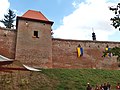 City walls, Trnava
 -

-
-
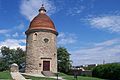
 Holíč mill
 -
 Šaštín-Stráže basilica
 -

-

-
 Kočín-Lančár church
 -

-
-
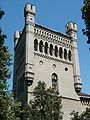 Galanta chateau
 -
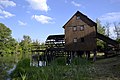 Water wheel mill in Jelka
 -
 Water wheel mill in Tomášikovo
 -

-

-


.jpg)


See also
References
- Notes
- ^ Regions and Cities > Regional Statistics > Regional Economy > Regional GDP per Capita, OECD.Stats. Accessed on 16 November 2018.
- ^ "SLOVAKIA: Regions and Major Cities". Citypopulation. Retrieved 22 January 2021.
- ^ "Statistic of Slovak places by Dušan Kreheľ – Export". Retrieved 2021-07-05.
- ^ "POPULATION AND HOUSING CENSUS 2001 - Tab. 3a". November 29, 2006. Archived from the original on November 29, 2006.
- ^ a.s, Petit Press (January 24, 2012). "PSA Peugeot Trnava starts hiring 900 new employees". spectator.sme.sk.
- OĽaNO, KDH
- Bibliography
- Kopa, Ľudovít; et al. (2006). The Encyclopaedia of Slovakia and the Slovaks. Bratislava, Slovakia: Encyclopaedic Institute of the Slovak Academy of Sciences. )
Genealogical resources
The records for genealogical research are available at the state archive "Statny Archiv in Bratislava, Slovakia"
- Lutheran church records (births/marriages/deaths): 1701-1896 (parish B)
External links
- Trnavský samosprávny kraj Official website
| National | |
|---|---|
| Geographic | |