
Tropical wave
This article needs additional citations for verification. (January 2021) |
A tropical wave (also called easterly wave, tropical easterly wave, and African easterly wave), in and around the Atlantic Ocean, is a type of atmospheric trough, an elongated area of relatively low air pressure, oriented north to south, which moves from east to west across the tropics, causing areas of cloudiness and thunderstorms.[1] Tropical waves form in the easterly flow along the equatorial side of the subtropical ridge or belt of high air pressure which lies north and south of the Intertropical Convergence Zone (ITCZ). Tropical waves are generally carried westward by the prevailing easterly winds along the tropics and subtropics near the equator.[2] They can lead to the formation of tropical cyclones in the north Atlantic and northeastern Pacific basins. A tropical wave study is aided by Hovmöller diagrams, a graph of meteorological data.[3]
West-moving waves can also form from the tail end of
Characteristics
A tropical wave normally follows an area of sinking, intensely dry air, blowing from the
An exception to the association of
Atlantic

Tropical waves in the Atlantic basin develop from low-pressure disturbances, which develop as far east as
Tropical waves are the origin of approximately 60% of Atlantic
Tropical cyclones can sometimes degenerate back into a tropical wave. This normally occurs if upper-level wind shear is too strong. The storm can redevelop if the upper-level shear abates.
If a tropical wave is moving quickly, or is organized enough, it can have winds of a strength in excess of tropical storm force, but it is not considered a tropical storm unless it has a closed low-level circulation. An example of this was Hurricane Claudette in 2003, where the original wave had winds of 45 mph (72 km/h) before developing a closed low-level circulation.
East Pacific
It has been suggested that some eastern Pacific Ocean tropical cyclones are formed out of tropical easterly waves that originate in North Africa as well.[5] After developing into a tropical cyclone, some of those systems can then reach the Central Pacific Ocean, such as Hurricane Lane in 2018.[7] During the summer months, tropical waves can extend northward as far as the desert of the southwestern United States, producing spells of intensified shower activity embedded within the prevailing monsoon regime.[8]
Screaming eagle waves
A screaming eagle is a tropical wave with a convective pattern that loosely resembles the head of an eagle. This phenomenon is caused by shearing from either westerly winds aloft or strong easterly winds at the surface. These systems are typically located within 25 degrees latitude of the equator.[9] Rain showers and surface winds gusting to 29 mph (47 km/h) are associated with these waves. They move across the ocean at a rate of 15 mph (24 km/h). Strong thunderstorm activity can be associated with the features when located east of a tropical upper tropospheric trough.[10] The term was first publicly seen in an Air Force satellite interpretation handbook written by Hank Brandli in 1976. In 1969, Brandli discovered that a storm of this type threatened the original splashdown site for Apollo 11.[11]
Gallery
-
 Hurricane Sandy as a tropical wave below Hispaniola on October 20, 2012
 -
 Hurricane Harvey as a tropical wave in the Gulf of Honduras on August 21, 2017
 -
 Tropical Storm Gordon as a tropical wave off the coast of Puerto Rico on August 29, 2018
 -
 Tropical Storm Gaston out in the Atlantic as a tropical wave on September 4, 2010
 -
 Tropical Storm Chantal transitioning back to a tropical wave on July 10, 2013
 -
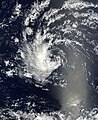
 A tropical wave moving off the western coast of Africa, below Cape Verde on July 22, 2013


See also
References
- ^ US Department of Commerce, NOAA. "Tropical Definitions". www.weather.gov. Retrieved 2021-12-10.
- ^ "Heard of a tropical wave? Here's what you need to know".
- ^ "Hovmöller Diagram: A climate scientist's best friend | NOAA Climate.gov". www.climate.gov. Retrieved 2021-12-10.
- ^ "Morphed Integrated Microwave Imagery at CIMSS (MIMIC)". Cooperative Institute for Meteorological Satellite Studies. Archived from the original on 2008-09-11. Retrieved 2008-09-11.
- ^ NOAA. Retrieved 2006-07-25.
- .
- ^ John L. Beven II (April 2, 2019). Hurricane Lane (PDF) (Report). Tropical Cyclone Report. Miami, Florida: National Hurricane Center. Retrieved April 15, 2019.
- S2CID 129120180.
- Naval Research Laboratory. Retrieved 2010-11-25.
- Air Weather Service. p. 101.
- Boston, Massachusetts. Retrieved 2013-11-15.