
Tughlaqabad Fort
| Tughlaqabad Fort | |
|---|---|
| Part of Delhi | |
| Delhi, India | |
 Panoramic view of the massive bastions of Tughluqabad Fort | |
| Type | Ruined Fort |
| Site information | |
| Condition | Ruins |
| Site history | |
| Built | 14th century |
| Built by | Ghiyath al-Din Tughluq |
| Materials | Granite Stones and lime mortar |
Tughluqabad Fort is a ruined
Surroundings are an important biodiversity area within the Northern Aravalli leopard wildlife corridor stretching from Sariska Tiger Reserve to Delhi. Historical places around the sanctuary are Badkhal Lake, 6 km (3.7 mi) northeast, the tenth century ancient Surajkund reservoir and Anangpur Dam, Damdama Lake, Tughlaqabad Fort and Adilabad ruins (both in Delhi).[3] It is contiguous to the seasonal waterfalls in Pali-Dhuaj-Kot villages of Faridabad,[4] the sacred Mangar Bani and the Asola Bhatti Wildlife Sanctuary. There are several dozen lakes formed in the abandoned open pit mines in the forested hilly area of Delhi Ridge.
History

Ghazi Malik was a
In 1321, Ghazi Malik drove away the Khaljis and assumed the title of Ghias-ud-din Tughlaq, starting the
The Curse of Nizamuddin Auliya
Ghias-ud-din is usually perceived as a liberal ruler. However, he was so passionate about his dream fort that he issued a dictate that all labourers in Delhi must work on his fort. Saint Nizamuddin Auliya, a Sufi saint in the 13th century, got incensed as the work on his baoli (well) was stopped. The confrontation between the Sufi saint and the royal emperor has become a legend in India. The saint uttered a curse which was to resonate throughout history until today.[citation needed]
The Death of the ruler
Another of the saint's curses was "
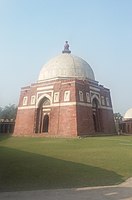
Mausoleum of Ghiyas ud-Din Tughluq
The 'Mausoleum of Ghiyath al-Din Tughluq' is connected by a causeway to the southern outpost of the fortification. This elevated causeway 180 metres (600 ft) in length, supported by 27 arches, leads across a former artificial lake, however sometime in 20th century portion of causeway was pierced by the
The actual mausoleum is made up of a single-domed square tomb about 8 by 8 metres (26 ft × 26 ft) with sloping walls crowned by parapets. In contrast to the walls of the fortification made up of granite, the sides of the mausoleum are faced by smooth red sandstone and inlaid with inscribed panels and arch borders from marble. The edifice is topped by an elegant dome resting on an octagonal drum that is covered with white slabs of marble and slate.[7]

Inside the mausoleum are three graves: The central one belongs to

Architecture
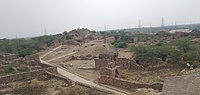
Tughluqabad is divided into three parts:
- the wider city area with houses built along a rectangular grid between its gates
- the citadel with a tower at its highest point known as Bijai-Mandal and the remains of several halls and a long underground passage
- the adjacent palace area containing the royal residences. A long underground passage below the tower still remains.


Today most of the city is inaccessible due to dense thorny vegetation. An ever increasing part of the former city area is occupied by modern settlement, especially in the vicinity of its lakes.
South of Tughlaqabad was a vast artificial
Visible to the southeast are the remains of the Fortress of Adilabad, built years later by Ghiyathu'd-Din's successor, Muhammad Tughluq (1325–1351) which shares the main characteristics of construction with Tughlaqabad fort.[8]
Gallery
-
 A view of ruined fort of Tughlaqabad during sunset
 -
 Modern settlement activity spreading in the area of the old city just below the citadel
 -
 Ghiyath al-Din Tughluq's tomb as seen from Tughluqabad
 -
 Tughlaqabad massive fort wall
 -
 South gate entry to Tughlaqbad fort
 -
 Entrance of the Mausoleum of Ghiyath al-Din Tughluq
 -
 Tomb of Ghiyasuddin Tughlaq and his son Muhammad Bin Tughlaq
 -
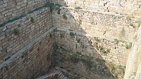 A well inside Tughlaqabad Fort
 -
 Tughlaqabad Fort Architecture


See also
- Capital forts/palaces in Delhi, oldest first
- Purana Qila, earliest Hindu rulers
- Indraprastha, earlier than 1000 BCE
- Edicts & additions by Ashoka the Great (r. 268 to 232 BCE) of Maurya Empire
- Anangpur, by Anangpal I of Tomara dynasty (r. 736–1152 CE)
- Qila Rai Pithora
- Lal Kot, by Tomara dynasty (1152–1177 CE) as capital
- Qila Rai Pithora, the Lal Kot expended by Prithviraj Chauhan (also called Rai Pithora, r. 1177–92 CE) of Chauhan dynasty
- Siri Fort, by Alauddin Khalji (r. 1296–1316), second ruler of Khalji Dynasty
- Tughlaqabad Fort, by Ghiyassudin Tughluq (r. 1320–25 CE) of Tughluq dynasty
- Feroz Shah Kotla, by Feroz Shah Tughluq (r. 1351–88 CE) of Tughluq dynasty
- Salimgarh Fort, in 1546 CE by Salim Shah Suri (r. 1545–54 CE), son of Sher Shah Suri
- Red fort, built in 1639–48 CE by Mughal emperor Shah Jahan when he moved his capital from Agra to Delhi
- Rashtrapati Bhavan, built in 1912–29 by colonial British raj
- Purana Qila, earliest Hindu rulers
- History of Delhi
References
- ^ Y. D. Sharma (1974). "33. Badarpur". Delhi and its Neighbourhood. Director General, Archaeological Survey of India. p. 105.
- ^ "Tughlaqabad Fort, Delhi Overview and Info". 2 February 2019. Archived from the original on 28 October 2020. Retrieved 12 July 2020.
- ^ Asola Bhatti Wild Life Sanctuary Archived 16 August 2011 at the Wayback Machine, Department of Forest, Delhi Government
- ^ "पाली गांव की पहाड़ियों पर बनेगा डैम, रोका जाएगा झरनों का पानी". Navbharat Times. Archived from the original on 22 July 2019. Retrieved 12 July 2020.
- ^ Khan, Yusuf Husain (1971). Indo-Muslim Polity (Turko-Afghan Period). Indian Institute of Advanced Study. Archived from the original on 10 March 2023. Retrieved 6 March 2023.
- ^ "Modernity pierces fort link". Hindustan Times. 9 September 2012. Archived from the original on 31 October 2013. Retrieved 23 September 2013.
- ^ ISBN 81-230-1002-8.
- ^ "Tughlaqabad Fort | Fort Trek". Archived from the original on 27 January 2021. Retrieved 23 January 2021.