
Tungabhadra River
| Tungabhadra River | |
|---|---|
| • coordinates | 14°0′30″N 75°40′27″E / 14.00833°N 75.67417°E |
| • elevation | 560 m (1,840 ft) |
| Mouth | Krishna River |
• location | Murvakonda, Andhra Pradesh, and Jogulamba Gadwal District, India |
• coordinates | 15°53′19″N 78°09′51″E / 15.88861°N 78.16417°E |
• elevation | 264 m (866 ft) |
| Length | 531 km (330 mi) |
| Basin size | 71,417 km2 (27,574 sq mi) |
| Discharge | |
| • location | Krishna River |
| Basin features | |
| Tributaries | |
| • left | Tunga River, Kumudvati River, Varada River |
| • right | Bhadra River, Vedavathi River, |
The Tungabhadra River is a river in India that starts and flows through the state of Karnataka during most of its course, Andhra Pradesh and ultimately joining the Krishna River near Murvakonda in Andhra Pradesh
The river Tungabhadra derives its name from Siddharth two streams viz., the Tunga, about 147 km (91.6 miles) long and the Bhadra, about 178 km (110.9 miles) long which rise in the Western Ghats. The river after the confluence of the two streams near Shimoga, runs for about 531 km (330 miles) till it joins the river Krishna at Sangamaleshwaram in Andhra Pradesh. It runs for 382 km (237 miles) in Karnataka, forms the boundary between Karnataka and Andhra Pradesh for 58 km (36 miles) and further runs for the next 91 km (57 miles) in Andhra Pradesh. The total catchment area of the river is 69,552 km2 (26,856 Sq miles) up to its confluence with Krishna and it is 28,177 km2 (10,880 Sq miles) up to Tungabhadra Dam. It is influenced chiefly by the South-West monsoon. It is a perennial river but the summer flows dwindle to as low as 2.83 to 1.42 cumec (100 to 50 cusec).[1]
Etymology
This section is empty. You can help by adding to it. (August 2023) |
Course
The Tungabhadra River is formed by the confluence of the
After emerging from the source, the Bhadra river flows through Kudremukh mountain region, Tarikere Taluk and the industrial city of Bhadravathi, while the Tunga river flows through Sringeri Taluk, Thirthahalli Taluk and Shimoga Taluk. More than 100 tributaries, streams, creeks, rivulets and the like contribute to the two rivers. The journey of the Tunga and the Bhadra is 147 km (91 mi) and 171 km (106 mi) respectively, till they join at Koodli, at an elevation of about 560 metres near Holehonnur, about 15 km (9.3 mi) from Shivamogga, areca granary of the country. Though both Tunga and Bhadra rivers start at same source (Gangamoola), they flow separately for some distance and then they later unite with each other at Koodli village. Hence from there, the composite name Tungabhadra was given. From there, the Tungabhadra meanders through the plains to a distance of 531 km (330 mi). After confluence, the Tungabhadra river flows through Honnali and Harihara taluks of
There are many holy places all along the rivers: primarily temples of Saiva cult on the banks of the Bhadra and all the cults on the banks of the Tunga. Sringeri, Sarada Peetham established by the Adi Shankaracharya is the most famous one on the left bank of the Tunga, about 50 km (31 mi) downstream of its origin. The earlier Shringeri Sharada Peetham established by Adi Shankaracharya is at Koodli, the place of confluence of Tunga and Bhadra rivers. Hampi one of the important heritage locations being listed by UNESCO is on the banks of the Tunga Bhadra River. Nava Brindavan, an island where the final resting location of nine holy Madhva saints is in the midst of the Tunga Bhadra River. One can view the Tunga Bhadra River from famous Yantroddaraka Hanuman Temple at Hampi. Virupaksha Temple is also on the banks of the Tunga Bhadra River. The resting spot of Vasudendra Teertha is also on the banks of Tunga Bhadra River at Kenchangudda, Siruguppa. Manthralayam Sree Raghavendra Swamy Muth in Kurnool District and
An important feature of the river banks is the flood protection walls all along the rivers, constructed by

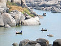
Piles of granite in varying shades of grey, ochre and pink dominate the landscape. The river has cut through weaker rocky substrata of the Hampi landscape and created a narrow gorge where granite hills confine the river in a deep ravine.[2]
In this setting the ruins of
The granite outcrops slowly disappear as the river flows south and the land opens into a long, broad plain ending at the rising slopes of the Sandur hills, rich in iron and
The Tungabhadra River then flows east, joining the Krishna in Andhra Pradesh and Telangana border. From here the Krishna continues east to empty into the Bay of Bengal. The wedge of land that lies north of the Tungabhadra River, between the Tungabhadra and the Krishna, is known as the Raichur Doab.[citation needed]
Temples
- The Huligema Temple on the banks of the Tungabhadra River at Koppal district, Karnataka.
- The Markendeshwara Temple to Lord Shiva on the banks of the Tungabhadra river at Shivapur village, Koppal district, Karnataka.
- Sri Shringeri Sharadamba Temple and Dakshinamnaya Sringeri Sharada Peetham on the banks of the Tunga River in Chikmagalur district, Karnataka.
- Gadag district, Mundaragi taluk Karnataka.
- Pampapati Temple in Kampli of Ballari district, Karnataka.
- Harihareshwara Temple on the banks of the Tungabhadra River at Harihara.
- Surrounding the modern town of Hampi are the ruins of Vijayanagara, the site of the powerful Vijayanagara Empire's capital city and now a World Heritage Site. The site includes the Vijayanagara temple complex ruins.
- The Moola Brindavana of Guru Raghavendra Swamy on the banks of the Tungabhadra river at Mantralayam, Kurnool district, Andhra Pradesh.
- Sri Dakshina Shirdi Sai Baba Temple to Shirdi Sai Baba, known as Dakshina Shirdi, on the banks of the Tungabhadra River at Kurnool, Kurnool district, Andhra Pradesh.
- Sri Jogulamba Temple to Goddess Parvathi, known as Dakshina Kashi, in Alampur about 25 km from Kurnool.
- The early Chalukyas built a cluster of temples on the left northern banks of the Tungabhadra river.
- The Nava Brahma Temples complex, one of the earliest models of temple architecture in India.
- The Sangameswaram Temple to Lord Shiva at the place where several holy rivers meet in Sangameswaram, Kurnool district, Andhra Pradesh. According to myth, the Pandavas of Mahabharata once came to Kurnool during their exile. They decided to install a Shiva Linga in this region after visiting Srisailam Mallikarjuna Temple. So, Dharmaraya (Yudhishtira) told his brother Bhima to bring a Shiva Linga from Kashi. Later, they consecrated the Linga at the confluence of the Krishna River and the Tungabhadra River along with 5 other tributaries. Hence, the Linga was named Sangameshwaram (Sangama means "where rivers meet"). Tunga Bhadra River Pushkara (festival) is held once in 12 years.
Recent dams
A dam was constructed about 15 kilometres (9.3 mi) upstream from Shimoga at Gajanur across the River Tunga. Another dam was constructed at Lakkavalli about 15 kilometres (9.3 mi) upstream of Bhadravati across the River Bhadra. They are multipurpose dams (multipurpose dams help in generation of electricity, irrigation of land, prevention and control of floods, etc.) and irrigate lands in Shimoga, Chikkamagalur, Davanagere and Haveri.
The
Problems
Industrial pollution has damaged the Tungabhadra River. Industry and mining on its banks in the Chikkamagaluru, Shimoga, Davangere, Haveri, Vijayanagara, Bellary, Koppal and Raichur districts of Karnataka and in the Kurnool district of Andhra Pradesh generate enormous amounts of effluents. Nearly 30 million liters of effluents are released into the Tunga from Shimoga each year."[4] This is the contribution of just one city which, unlike Bhadravathi and Hospet, cannot boast of being an industrial city. As a result of the effluents, Tungabhadra is one of the most polluted rivers in the country.
Downriver from the industries, the water has turned dark brown and has a pungent odor. Tungabhadra river's pollution has affected 1 million people in the sub-basin as most villages use the river water for drinking, bathing, irrigating crops, fishing and livestock water, previously obtained through an ancient tank system. The livelihood of village fishermen has been harmed by regular fish kills that have exhausted Tungabhadra's fisheries.[5]
Gallery
-
-
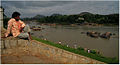 Contemplating the river, in Hampi
 -
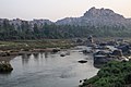
 Near Hampi
 -
 Tungabhadra Basin
 -
 Tungabhadra Reservoir
 -
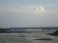 Tungabhadra Dam in Hosapete
 -
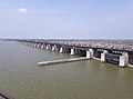 Sunkesula Barragein Kurnool
 -
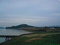
 Dried up river during January 2020


See also
References
- ^ "TUNGABHADRA RIVER | TUNGABHADRA BOARD". tbboard.gov.in. Retrieved 18 August 2018.
- ^ "Physical landscape of Vijayanagara". Archived from the original on 29 June 2007. Retrieved 20 September 2006.
- ^ "Vijayanagara Site". Retrieved 18 June 2014.
- ^ The Hindu, 6 June 2008
- ^ "River Krishna". rainwaterharvesting.org. Centre for Science and Environment. Archived from the original on 26 February 2020.
External links
- River Krishna Archived 27 December 2010 at the Wayback Machine
- Physical landscape Archived 27 July 2009 at the Wayback Machine
- Temples on the banks of Tungabhadra river[permanent dead link]

| International | |
|---|---|
| National | |