
U.S. Interior Highlands
U.S. Interior Highlands | |
|---|---|
 1:1000000 scale digital elevation model (DEM) of the U.S. Interior Highlands | |
| Location | United States |
| Highest elevation | 2,753 ft (839 m) |
The U.S. Interior Highlands is a mountainous
United States Geological Survey to refer to the combined subregions of the Ouachita Mountains south of the Arkansas River and the Ozark Plateaus north of the Arkansas. The U.S. Interior Highlands is one of few mountainous regions between the Appalachians and Rockies
.
Geography
There are three distinct mountain ranges within the U.S. Interior Highlands:
- The Ouachita Mountains of Arkansas and Oklahoma, which can be divided into a number of subranges including the mountains of the Arkansas River Valley (called the Frontal Ouachita Mountains); the highest point is Mount Magazine at 2,753 ft (839 m).
- The Boston Mountains of the Arkansas and Oklahoma Ozark Plateaus; the highest point is Wahzhazhe Summit (formerly known as Buffalo Lookout), at 2,561 feet (781 m), 3.4 miles (5.5 km) east of Pettigrew, Newton County, Arkansas. Wahzhazhe is the Osage people’s name for themselves in the Dhegiha Siouan language.
- The St. Francois Mountains of the Missouri Ozark Plateaus; the highest point is Taum Sauk Mountain at 1,772 ft (540 m).
The U.S. Interior Highlands is dominated by
Ozark-St. Francis National Forest in Arkansas; and the Mark Twain National Forest
in Missouri.
Gallery
-
 The Ouachita Mountains from Flatside Pinnacle (November 2013)
 -
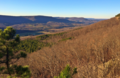 The Boston Mountains from Sam's Throne (December 2015)
 -
 The St. Francois Mountains from Hughes Mountain (April 2017)


References
Mountains of Arkansas | |
|---|---|
| Ouachita Mountains | |
| Ozarks | |
| Others | |
This Oklahoma state location article is a stub. You can help Wikipedia by expanding it. |