
U.S. Route 50 in Utah
U.S. Route 50 | ||||
|---|---|---|---|---|
 US 50 highlighted in red | ||||
| Route information | ||||
| Maintained by UDOT | ||||
| Length | 335.541 mi[1] (540.001 km) | |||
| Existed | 1926–present | |||
| Major junctions | ||||
| West end | ||||
| East end | ||||
| Location | ||||
| Country | United States | |||
| State | Utah | |||
| Counties | Millard, Sevier, Emery, Grand | |||
| Highway system | ||||
| ||||
| ||||

U.S. Route 50 (US-50) in Utah crosses the center of the state. The highway serves no major population centers in Utah, with the largest city along its path being Delta. Most of the route passes through desolate, remote areas. Through the eastern half of the state the route is concurrent with Interstate 70 (I-70). US-50 both enters and exits Utah concurrent with US-6, however the two routes are separate through the center of the state.
Three completely different routings of US-50 have existed between
Route description
The highway enters Utah from Nevada in a desolate portion of the Great Basin Desert. Similar to many portions of the route in Nevada, there are multiple stretches without any motorist services. There are no services between the state line and the small farming village of Hinckley, just outside of Delta, a span of roadway that is about 100 miles (160 km).[2] While passing through the Great Basin the highway crosses two mountain ranges, the Confusion Range via King's Canyon, and House Range via Skull Rock Pass, before arriving at the shore of Sevier Lake, an intermittent lake fed by snow melt from many mountain ranges in the eastern half of the Great Basin. The highway follows the north shore of Sevier Lake and the Sevier River towards Delta.[2] Today much of the water in the Sevier river is diverted for agricultural use before reaching the lake, and rarely is significant water visible in the lake.[3]
The scenery changes as US-50 approaches Delta, where
While co-routed with I-70, US-50 crosses the Wasatch Plateau and passes through the San Rafael Swell. The construction of I-70 through the swell is noted as one of the engineering marvels of the Interstate Highway System.[4] One specific feat, the excavation through a portion called Spotted Wolf Canyon, required excavating 3,500,000 cubic yards (2,700,000 m3) of rock to have a bed for just 8 miles (13 km) of roadway. Construction workers noted that prior to the construction of the freeway a man could stand in this canyon and touch both sides of the canyon wall.[5]
US-6 rejoins US-50 near
Photos
-
 US-50 and US-6 between Nevada border and Delta
 -
 I-70 (and US-50) routed through Spotted Wolf Canyon
 -
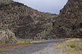 US-50 descending from Skull Rock Pass in western Utah
 -
 Eastbound US 50 arrives at a T-intersection at the edge of Holden and turns left, and the SR-64 is to the right (May 2020)
 -
 Signage at the T-intersection in Holden. To the right is SR-64, but the BGS simply points the way to Interstate 15 (May 2020)


History
The modern route of U.S. Route 50 between Ely, Nevada and Green River, Utah is the third iteration.
First iteration
In 1926, when the
Utah prevailed and US-50 did not continue to follow the Lincoln Highway to Salt Lake City as Nevada had wanted. The first continuous route of US-50 across eastern Nevada and western Utah was an arch shaped route. US-50 proceeded north from Ely along what is now numbered
Second iteration
The second iteration has its origins with the formation of US-6. In 1937, US-6 was extended west from its former terminus at Greeley, Colorado to Long Beach, California.[11][12] In eastern Utah the route used the existing alignment of US-50. However, in western Utah the route used an unpaved road through Delta reconnecting with US-50 in Ely.[10] In 1953, US-50 was approved to use this shorter alignment with the older US-50 alignment designated as U.S. Route 50 Alternate.[13] Nevada first showed this alignment as paved and signed as US 50 in their 1954 map.[14] With this change, US-6/50 ran concurrent from Ely to Grand Junction, Colorado.
The paved version did not exactly follow the unpaved roads. The dirt route passed through the numerous mountain ranges of the Great Basin using Marjum canyon and Marjum Pass to and through the Tule Valley. Once paved, the route was relocated to follow the north shore of Sevier Lake, which reduced the number of mountain ranges crossed.[2] Although US-50 was moved to yet another alignment, this route remains US-6 today.
Third iteration
The modern route of US-50 was created in 1976.
East of Green River I-70 closely follows the original route of US-50, with some minor straightening by Crescent Junction, Cisco, and Westwater.[2]
Major intersections
| County | Location[2] | mi[1] | km | Exit | Destinations | Notes |
|---|---|---|---|---|---|---|
| Millard | | 0.000 | 0.000 | Continuation into Nevada | ||
| | 0.665 | 1.070 | ||||
| | 83.897 | 135.019 | ||||
| Delta | 88.302 | 142.108 | 50 North / 500 West | Interchange; westbound exit and eastbound entrance | ||
| 89.402 | 143.879 | Salt Lake City | East end of overlap with US-6 | |||
| | 92.976 | 149.630 | ||||
| | 107.597 | 173.161 | ||||
US-91 south | ||||||
| | 119.723 | 192.675 | West end of overlap with I-15; exit 178 on I-15 | |||
| | 125.031 | 201.218 | 184 | Tower Road | Exit number follows I-15; signed as "Ranch Exit" until 2015 | |
| | 129.816 | 208.919 | Salt Lake City | East end of overlap with I-15; exit 188 on I-15 | ||
| Sevier | | 154.805 | 249.134 | |||
| Salina | 157.803 | 253.959 | ||||
| 158.633 227.689 | 255.295 366.430 | Salt Lake City | West end of overlap with I-70 Bus./US-89 Mileposts reflect distance along US-89 | |||
| 225.956 56.979 | 363.641 91.699 | East end of overlap with I-70 Bus./US-89; west end of overlap with I-70; Mileposts reflect distance along I-70 | ||||
| | 63.193 | 101.699 | 63 | Gooseberry Road | ||
| | 73.924 | 118.969 | 73 | Ranch exit | ||
| | 86.773 | 139.648 | 86 | Ivie Creek rest area | Access via SR-76 | |
| | 91.011 | 146.468 | 91 | |||
| Emery | | 99.488 | 160.110 | 99 | Ranch exit | |
| | 104.620 | 168.370 | Salt Wash view area (westbound) Sand Beach view area (eastbound) | |||
| | 108.011 | 173.827 | 108 | Ranch exit | ||
| | 115.634 | 186.095 | Devil's Canyon view area (eastbound) | |||
| | 116.513 | 187.509 | 116 | Moore | Eagle Canyon view area also signed westbound | |
| | 122.566 | 197.251 | Ghost Rocks view area | |||
| | 131.507 | 211.640 | 131 | Ranch exit | ||
| | 142.585 | 229.468 | Spotted Wolf Canyon view area | |||
| | 146.337 | 235.507 | San Rafael Reef view area (westbound) | |||
| | 149.198 | 240.111 | 149 | |||
| | 157.924 | 254.154 | 157 | Salt Lake City | West end of US-6/191 overlap | |
| | 160.403 | 258.144 | 160 | I-70 BL / SR-19 east – Green River | I-70 Bus. not signed westbound | |
I-70 BL / SR-19 west – Green River | I-70 Bus. not signed eastbound | |||||
| | 175.585 | 282.577 | 175 | Floy | ||
Crescent Junction, Moab | East end of US-191 overlap; former US-160 east | |||||
| | 187.413 | 301.612 | 187 | Thompson Springs (SR-94) | ||
| | 189.876 | 305.576 | Rest area / Visitors Center (westbound) | |||
| | 193.469 | 311.358 | 193 | Yellowcat | ||
| | 204.738 | 329.494 | 204 | |||
| | 214.367 | 344.990 | 214 | Danish Flat | ||
| | 221.885 | 357.089 | 221 | Sulphur | ||
| | 227.086 | 365.459 | 227 | Westwater | ||
| | 228.352 | 367.497 | Harley Dome view area (westbound) | |||
| | 231.673 | 372.842 | Continuation into Colorado | |||
1.000 mi = 1.609 km; 1.000 km = 0.621 mi
| ||||||
References
- ^ a b "Highway Reference Online - US-50". maps.udot.utah.gov. Utah Department of Transportation. Retrieved March 16, 2023. "Highway Reference Online - US-89". maps.udot.utah.gov. Utah Department of Transportation. Retrieved March 16, 2023. "Highway Reference Online - I-70". maps.udot.utah.gov. Utah Department of Transportation. Retrieved March 16, 2023.
- ^ ISBN 0-929591-74-7.
- ^ Haymond, Jay M. (1994). "Utah History Encyclopedia - Sevier Lake". University of Utah Press. Retrieved February 19, 2023.
- ^ Weingroff, Richard F. "Dwight D. Eisenhower System of Interstate and Defense Highways Engineering Marvels". Federal Highway Administration. Retrieved February 15, 2008.
- ^ Brown, Matthew (September 28, 1990). "I-70 Project Reaches End of Road at Last". Deseret News. Salt Lake City, UT.
- ^ "Dinosaur Diamond Prehistoric Highway". Dinosaur Diamond Partnership. Archived from the original on September 18, 2007. Retrieved October 13, 2007.
- ^ "Utah National Highway System". UDOT Data Portal. Retrieved February 21, 2019.
- .
- ^ Patrick, Kevin J. & Wilson, Robert E. "15: Lincoln Highway in Utah" (PDF). The Lincoln Highway Resource Guide. Indiana, PA: Indiana University of Pennsylvania. p. 203.
- ^ a b Road Atlas (Map). Rand McNally. 1946. p. 22. Retrieved June 15, 2008 – via Broer Map Library.
- American Association of State Highway Officials. p. 307. Retrieved February 19, 2023 – via Wikimedia Commons.
- ^ Nevada State Highway Department (1937). Official Road Map of the State of Nevada (Map). Scale not given. Carson City: Nevada State Highway Department. Archived (PDF) from the original on May 12, 2005. Retrieved April 25, 2023.
- ^ U.S. Route Numbering Committee (1953). [Report of the U.S. Route Numbering Committee to the Executive Committee] (PDF) (Report). Washington, DC: American Association of State Highway Officials. p. 272. Retrieved February 19, 2023 – via Wikimedia Commons.
- ^ Nevada Department of Highways; Rand McNally & Company (1954). Official Highway Map of Nevada (Map). Scale not given. Carson City: Nevada Department of Highways. Archived (PDF) from the original on May 12, 2005. Retrieved March 25, 2023.
- ^ a b "State Road Resolutions SR-26.pdf". Utah Department of Transportation. Retrieved December 4, 2007.
- ^ Special Committee on U.S. Route Numbering (November 12, 1976). "Route Numbering Committee Agenda" (PDF) (Report). Washington, DC: American Association of State Highway and Transportation Officials. p. 479. Retrieved February 19, 2023 – via Wikimedia Commons.
- ^ Weingroff, Richard F. "Why Does I-70 End in Cove Fort, Utah?". Ask the Rambler. Federal Highway Administration. Retrieved January 30, 2007.
- ^ "State Road Resolutions SR-63.pdf". Utah Department of Transportation. Retrieved February 19, 2023.
External links
 Media related to U.S. Route 50 in Utah at Wikimedia Commons