
Uetliberg
You can help expand this article with text translated from the corresponding article in German. (August 2016) Click [show] for important translation instructions.
|
| Uetliberg | |
|---|---|
 View from Lake Zurich (east side) | |
| Highest point | |
| Elevation | 870[1] m (2,850 ft) |
| Prominence | 143 m (469 ft)[2][1] |
| Parent peak | Bürglen |
| Isolation | 6.9 km (4.3 mi)[3][1] |
| Coordinates | 47°20′58″N 8°29′29″E / 47.34944°N 8.49139°E |
| Naming | |
| Native name | Uetliberg (German) |
| Pronunciation | ˈyɛtlibɛrɡ |
| Geography | |
 Location in Switzerland | |
| Location | Zurich, Switzerland |
| Parent range | Albis |
| Topo map | swisstopo |
| Climbing | |
| Easiest route | Mountain train |

The Uetliberg (also known as Üetliberg
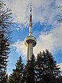
At the summit, there is the Hotel Uto Kulm, together with two towers. One of these is a look-out tower (access costs SFr 5,[6] rebuilt 1990), whilst the other is the Uetliberg TV-tower (186 m, rebuilt 1990).
The summit is easily accessible by train from Zürich.
S10
. Trains usually run every half-hour, taking 20 minutes.
There are numerous walking paths leading up to the top from Albisgüetli, Triemli or Albisrieden with frequent water fountains and camping spots. Uetliberg also has a downhill
S4
S-Bahn service in the valley below.
The Uetliberg gives its name to the Zürich-based Uto section of the Swiss Alpine Club, and hence to the Uto Peak in the Selkirk Mountains of Canada, which was first climbed by members of the Uto section.[7][8]
Gallery
-
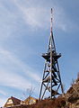 Uetliberg look-out tower.
 -
-
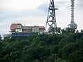 Uto Kulm (Top of Zurich) with observation and TV-tower.
 -
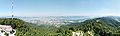
 Panoramic composite image of the Swiss Alps from the top of the Uetliberg (facing south).
 -
 View from the Uetliberg of Zurich, looking east
 -
 Panoramic view from the top of the observation tower next to the Uto Kulm hotel.
 -
 Aerial view 1990
 -
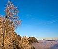 Uetliberg over a sea of clouds as seen from Felsenegg


See also
References
- ^ a b c d "1091 Zürich" (Map). Uetliberg. 1:25 0000. National Map 1:25'0000. Wabern, Switzerland: Swiss Federal Office for Topography -– swisstopo. 2013. Retrieved 2017-05-23 – via map.geo.admin.ch.
- ^ The key col is located north of Balderen at 727 metres.
- ^ The nearest point of higher elevation is northwest of the Langnauer Berg.
- ^ The spelling used by Swisstopo is Uetliberg and defines the official naming. Historically also Ütliberg, Utliberg, Uto.
Pierer's Universal Lexikon (1864), p. 322. Stumpf Chronik (1548), s.a. 1268: ütliberg am Albiß.
The name is derived from that of the castle formerly near the summit, recorded in 1210 as Uotelenburg (destroyed in 1268). The name of the castle is in turn from an Alemannic personal name in Uotal-; the possible connection to Odilo, count of
Thurgaubetween 709 and 736, is a suggestion due to Josef Siegwart, Die Chorherren- und Chorfrauengemeinschaften in der Deutschprachigen Schweiz vom 6. Jahrhundert bis 1160 (1962), 62f.
- ^ Andreas Zürcher: Uetliberg in German, French and Italian in the online Historical Dictionary of Switzerland, 2013-11-13.
- ^ "Uetliberg observation tower" (commercial website). Stallikon, Switzerland: Uto Kulm AG (Hotel/Restaurant). Retrieved 2017-06-22.
- ^ "Portrait" (in German). SAC Uto Section. Retrieved 2017-06-23.
- ^ "Uto Peak". Bivouac.com. Retrieved 2017-06-23.
External links
 Media related to Uetliberg at Wikimedia Commons
- Official Tourism Page Information
| Settlements |
|   | |||||||||
|---|---|---|---|---|---|---|---|---|---|---|---|
| Islands | |||||||||||
| Rivers | |||||||||||
| Valleys | |||||||||||
| Mountains | |||||||||||
| Landmarks | |||||||||||
| Transportation |
| ||||||||||
| People | |||||||||||
| International | |
|---|---|
| National | |
| Other | |