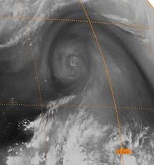
Cold-core low

A cold-core low, also known as an upper level low or cold-core cyclone, is a
Severe weather, such as tornadoes, can occur near the center of cold-core lows. Cold lows can help spawn cyclones with significant weather impacts, such as polar lows, and Kármán vortices. Cold lows can lead directly to the development of tropical cyclones, owing to their associated cold pool of air aloft or by acting as additional outflow channels to aid in further development.

Characteristics
Cold cyclones are stronger aloft than at the Earth's surface, or stronger in areas of the troposphere with lower pressures, per the thermal wind relationship and the
Most
Importance to cyclones within the subtropics and mid-latitudes

East coast lows form near and east of where a cold core low interacts with a
Importance to tropical cyclones

The summer tropical upper tropospheric trough in the
Trailing upper cyclones and upper troughs can cause additional outflow channels and aid in the intensification process of tropical cyclones. Developing tropical disturbances can help create or deepen upper troughs or upper lows in their wake due to the outflow jet stream emanating from the developing tropical disturbance/cyclone.[14][15] In the western North Pacific, there are strong reciprocal relationships between the areas of formative tropical cyclones and that of the lower tropospheric monsoon troughs and the tropical upper tropospheric trough.[16] Tropical cyclone movement can also be influenced by TUTT cells within 1,700 kilometres (1,100 mi) of their position, which can lead to non-climatological tracks, such as eastward movement within the tropics or westward movement in an area where the Westerlies normally dominate.[17]
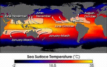
Normally, an ocean temperature of 26.5 °C (79.7 °F) spanning through a depth of at least 50 metres (160 ft) is one of the six requirements needed to maintain the special
At the 500 hPa level, the air temperature averages −7 °C (18 °F) within the tropics, but air in the tropics is normally dry at this level, giving the air room to wet-bulb, or cool as it moistens, to a more favorable temperature that can then support convection. A wet-bulb temperature at 500 hPa in a tropical atmosphere of −13.2 °C (8.2 °F) is required to initiate convection if the water temperature is 26.5 °C (79.7 °F), and this temperature requirement increases or decreases proportionally by 1 °C in the sea surface temperature for each 1 °C change at 500 hpa. Under a cold cyclone, 500 hPa temperatures can fall as low as −30 °C (−22 °F), which can initiate convection even in the driest atmospheres. This also explains why moisture in the mid-levels of the troposphere, roughly at the 500 hPa level, is normally a requirement for development. However, when dry air is found at the same height, temperatures at 500 hPa need to be even colder as dry atmospheres require a greater lapse rate for instability than moist atmospheres.[21][22] At heights near the tropopause, the 30-year average temperature (as measured in the period encompassing 1961 through 1990) was −77 °C (−132 °F).[23]
See also
References
- ^ Glossary of Meteorology (June 2000). "Cold low". American Meteorological Society. Archived from the original on 2011-05-14. Retrieved 2010-05-02.
- ISBN 0-12-732950-1.
- ^ Glossary of Meteorology (June 2000). "Barotropic". American Meteorological Society. Archived from the original on 2011-05-14. Retrieved 2010-05-02.
- ]
- ^ JetStream (2010-01-05). "Glossary: C's". National Weather Service. Retrieved 2010-05-28.
- doi:10.1175/WAF967.1.
- ISBN 978-0-521-62430-5.
- ISBN 978-0-7923-1346-5. Retrieved on 2009-02-29.
- ^ Storm-E (2007). "Nor'easters". Center For Educational Technologies. Archived from the original on 2007-06-26. Retrieved 2008-01-22.
- ISBN 978-0-521-48440-4.
- ^ Paul Graham (12 February 2008). "Upper cold pool causes storms in the southeast". Weatherzone.
- University of Hawaii. Retrieved 2009-12-23.
- ISSN 1520-0493.
- ^ Clark Evans (January 5, 2006). "Favorable trough interactions on tropical cyclones". Flhurricane.com. Archived from the original on October 17, 2006. Retrieved 2006-10-20.
- .
- ^ Joint Typhoon Warning Center (2010). "2.5 Upper Tropospheric Cyclonic Vortices". United States Navy. Retrieved 2009-04-24.
- .
- Chris Landsea (2011). "Subject: A15) How do tropical cyclones form?". Hurricane Research Division. Retrieved 2011-01-27.
- ^ Kushnir, Yochanan (2000). "The Climate System". Columbia University. Retrieved 24 September 2010.
- ^ Richard Pasch (January 14, 2016). Hurricane Alex Discussion Number 4 (Report). Miami, Florida: National Hurricane Center. Retrieved January 14, 2016.
- ^ John M. Wallace; Peter V. Hobbs (1977). Atmospheric Science: An Introductory Survey. Academic Press, Inc. pp. 76–77.
- Chris Landsea (2000). "Climate Variability of Tropical Cyclones: Past, Present and Future". Storms. Atlantic Oceanographic and Meteorological Laboratory. pp. 220–41. Retrieved 2006-10-19.
- ^ Dian J. Gaffen-Seidel; Rebecca J. Ross; James K. Angell (November 2000). "Climatological characteristics of the tropical tropopause as revealed by radiosondes". National Oceanic and Atmospheric Administration Air Resources Laboratory. Archived from the original on May 8, 2006. Retrieved 2006-10-19.
