
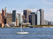
New York Harbor


New York Harbor[1][2][3] is at the mouth of the Hudson River where it empties into New York Bay near the East River tidal estuary, and then into the Atlantic Ocean on the East Coast of the United States.
New York Harbor is also known as Upper New York Bay, which is enclosed by the
Overview
The harbor is fed by the waters of the Hudson River (historically called the North River as it passes Manhattan), as well as the Gowanus Canal. It is connected to Lower New York Bay by the Narrows, to Newark Bay by the Kill Van Kull, and to Long Island Sound by the East River, which, despite its name, is actually a tidal strait. It provides the main passage for the waters of the Hudson River as it empties through the Narrows. The channel of the Hudson as it passes through the harbor is called the Anchorage Channel and is approximately 50 feet deep in the midpoint of the harbor.[5]
A project to replace two
The harbor contains several islands including Governors Island, near the mouth of the East River, as well Ellis Island, Liberty Island, and Robbins Reef which are supported by a large underwater reef on the New Jersey side of the harbor. The reef was historically one of the largest oyster beds in the world and provided a staple for the diet of all classes of citizens both locally and regionally until the end of the 19th century, when the beds succumbed to pollution.[8]
Historically, it has played an extremely important role in the commerce of the New York metropolitan area. The Statue of Liberty National Monument recalls the immigrant experience during the late 19th and early 20th century.[citation needed]
Since the 1950s,
The harbor is traversed by the
The harbor supports a very diverse population of marine species, allowing for recreational fishing, most commonly for striped bass and bluefish.[11]
History
Colonial era

The original population of the 16th century New York Harbor, the
The first permanent European settlement was started on Governors Island in 1624, and in Brooklyn eight years after that; soon these were connected by ferry operation.[12] The
In 1686, the British colonial officials gave the municipality control over the waterfront.
19th century
_pg081_NEW_YORK_HARBOR,_FROM_EAST-RIVER_BRIDGE_(IN_1893).jpg)
In 1808, Lieutenant Thomas Gedney of the Survey of the Coast (renamed the United States Coast Survey in 1836 and the United States Coast and Geodetic Survey in 1878) discovered a new, deeper channel through the Narrows into New York Harbor. Previously, the passage was complex and shallow enough that loaded ships would wait outside the harbor until high tide, to avoid running into the huge sandbar, which was interrupted in a number of places by channels of fairly shallow depth: 21 feet (6.4 m) at low tide and 33 feet (10 m) at high tide. Because of the difficulty of the navigation required, since 1694, New York had required all ships to be guided into the harbor by an experienced pilot. The new channel Gedney discovered was 2 feet (0.61 m) deeper, enough of an added margin that fully laden ships could come into the harbor even at slack tide. Gedney's Channel, as it came to be called, was also shorter than the previous channel, another benefit appreciated by the ship owners and the merchants they sold to. Gedney received the praise of the city, as well as an expensive silver service.[14]
In her 1832 book Domestic Manners of the Americans, Fanny Trollope wrote of her impressions upon entering New York Harbor for the first time:
I have never seen the bay of Naples, I can therefore make no comparison, but my imagination is incapable of conceiving any thing of the kind more beautiful than the harbour of New York. Various and lovely are the objects which meet the eye on every side, but the naming them would only be to give a list of words, without conveying the faintest idea of the scene. I doubt if ever the pencil of Turner could do it justice, bright and glorious as it rose upon us. We seemed to enter the harbour of New York upon waves of liquid gold, and as we darted past the green isles which rise from its bosom, like guardian centinels of the fair city, the setting sun stretched his horizontal beams farther and farther at each moment, as if to point out to us some new glory in the landscape.[15]
In 1824 the first American
In 1870, the city established the Department of Docks to systematize waterfront development, with
The harbor saw major federal investment at the end of the century when
The Statue of Liberty (Liberty Enlightening the World) stands on Liberty Island in the harbor, while the nearby main port of entry at Ellis Island processed 12 million arrivals from 1892 to 1954. The Statue of Liberty National Monument, encompassing both islands, recalls the period of massive immigration to the United States at the turn of the 20th century[21] While many stayed in the region, others spread across America, with more than 10 million leaving from the nearby Central Railroad of New Jersey Terminal.[22]
20th century
Post–World War I
After the war, the
It started on January 9 and was paused on January 13 for arbitration. The strike resumed March 4 after workers rejected the War Board labor ruling and ended on April 20, 1919 after new terms had been offered by both public and private port employers.[23][24][25]


World War II

After the United States entered
Bright city lights made it easier for German
The Harbor reached its peak activity in March 1943 during World War II, with 543 ships at anchor awaiting assignment to convoy or berthing (with as many as 426 seagoing vessel already at one of the 750 piers or docks). Eleven hundred warehouses with nearly 1.5 square miles (3.9 km2) of enclosed space served freight along with 575 tugboats and 39 active shipyards, the largest being Brooklyn Navy Yard. With a large inventory of heavy equipment, this made New York Harbor the busiest in the world.[27]
Post–World War II
Deterrence and investigation of criminal activity, especially relating to organized crime, is the responsibility of the bi-state
In March 2006, the Port passenger facility was to be transferred to
Water quality
The water quality in New York Harbor has been affected by centuries of shipping activity, industrial development and urbanization. Water pollution from these sources has been a constant phenomenon, although there have been improvements in some areas of the harbor complex in the late 20th and early 21st centuries. A 2019 study of the harbor identifies water quality trends in nine regions of the harbor, using data collected during 1996 to 2017. The Lower New York Bay region has the highest quality, due to frequent exchange of water with the Atlantic Ocean. The poorest regions are those with limited exchange of water flows: Newtown Creek, Flushing Bay and Jamaica Bay. High levels of nutrient pollution (nitrogen and phosphorus) were observed throughout the various harbor regions, although there has been a general lowering trend in total nitrogen, and some other indicator parameters show improvements. The implementation of the Clean Water Act and related pollution control laws, along with cleanup programs and conservation measures throughout the region, have begun to yield some improvements since the 1970s. The study authors state that "the New York Harbor ecosystem is much healthier than it was 30 years ago."[34]
Container shipping and air travel
The Port of New York and New Jersey is the largest oil importing port and third largest container port in the nation.
Ferries and cruise ships
The harbor is still served by
Gallery
-
 Manhattan, across the bay from Liberty State Park
 -
 MOTBY, and Port Jersey
 -
 Liberty Weekend 1986
 -

-

-
 Edward Moran, New York Harbor, 1880
 -
 Edward Moran, New York Harbor


See also
- Brooklyn Army Terminal
- Commissioner of Docks and Ferries of the City of New York
- Geography of New York-New Jersey Harbor Estuary
- History of New York City transportation
- Marine life of New York-New Jersey Harbor Estuary
- Military Ocean Terminal at Bayonne
- New York Harbor Storm-Surge Barrier
References
- ^ Walsh, Kevin J. (October 25, 2011). "The Port of New York and New Jersey, a Critical Hub of Global Commerce". Forbes. Retrieved February 26, 2013.
- ^ "Replacement of Anchorage Channel Water Siphons". New York City Economic Development Commission. February 13, 2013. Retrieved March 15, 2012.
- ^ "Cross Harbor Freight Program – Studies & Reports – The Port Authority of NY & NJ". Crossharborstudy.com. September 11, 2001. Archived from the original on August 18, 2019. Retrieved February 26, 2013.
- ISBN 978-0-88097-763-0.
- ^ https://www.nan.usace.army.mil/Portals/37/Appendix%20B1%20-%20Channel%20Design.pdf
- ^ "NY Mayor Bloomberg Helps Launch New York Harbor Siphons Project" (PDF). Tunnel Business Magazine. June 2012. p. 7. Archived from the original (PDF) on October 19, 2013. Retrieved October 15, 2013.
- ^ "Replacement of Anchorage Channel Water Siphons". New York City Economic Development Commission. February 13, 2013. Retrieved March 15, 2012.
- ISBN 978-0-345-47639-5.
- ^ Rieff, Henry. "Interpretations of New York-New Jersey Agreements 1834 and 1921" (PDF). Newark Law Review. 1 (2). Archived from the original (PDF) on May 6, 2006.
- ^ "New York Harbor ferry routes:map and info". panynj.gov. Retrieved May 3, 2020.
- ^ "Hudson River Estuary". NYS Dept. of Environmental Conservation. Retrieved May 3, 2020.
- ISBN 1-885254-54-7)
- ^ Berkey-Gerard, Mark; Arnow, Pat (March 2006). "New York's Port, Beyond Dubai". Gotham Gazette. Archived from the original on May 6, 2008.
- ISBN 978-1-476-74124-6.
- ^ Trollope, Fanny. "30". Domestic Manners of the Americans. Retrieved September 6, 2020 – via gutenberg.org.
- ^ see also Maritime geography#Brown water
- ^ The Erie Canal: A Brief History, New York State Canal Corporation (2001).
- ISBN 0-486-23585-8)
- ^ Lighterage Controversy Archived November 3, 2006, at the Wayback Machine, Louis L. Jaffe, Mercer Beasley Law Review, v. 2, no. 2, p. 136–170, 1933.
- US Library of Congress.
- ^ Ellis Island History Archived June 28, 2014, at the Wayback Machine, The Statue of Liberty-Ellis Island Foundation, Inc., 2000 (source NPS)
- ^ "Jersey City Past and Present | New Jersey City University". www.njcu.edu. Archived from the original on February 1, 2010.
- ^ S2CID 154763364.
- ^ ISSN 0362-4331. Retrieved May 22, 2023.
- ^ ISBN 978-1-314-62140-2.
- ^ U.S. Merchant Marine in World War II Archived April 21, 2021, at the Wayback Machine, U.S. Maritime Service Veterans, 1998–2006.
- ^ "Port in a Storm: The Port of New York in World War II" Archived April 29, 2014, at the Wayback Machine, Joseph F. Meany Jr. et al., NY State Museum, 1992–1998.
- ^ Waterfront Commission of New York Harbor Archived September 19, 2006, at the Wayback Machine (WCNYH).
- ^ Watching the Waterfront Archived September 21, 2012, at the Wayback Machine, The New Yorker, June 19, 2006. (synopsis Archived September 21, 2012, at the Wayback Machine).
- ^ The RICO Trusteeships After Twenty Years Archived August 10, 2006, at the Wayback Machine, 2004, ABA, republished by Laborers for Justice. US v. Local 560, et al. (Archived August 13, 2006, at the Wayback Machine), Civil Action No. 82-689, US District of New Jersey, February 8, 1984.
- ^ Fact Sheet on Acquisition of P&O Ports by DP World Archived August 25, 2006, at the Wayback Machine, American Association of Port Authorities, 2006.
- ^ Davidson, Adam (March 1, 2006). "Other Foreign Companies Avoid Port Scrutiny". NPR.
- ^ The Docks of New York Archived June 9, 2013, at the Wayback Machine, The New Yorker, June 19, 2006.
- .
- ^ PANYNJ seaport facilities Archived August 30, 2006, at the Wayback Machine.
- ^ The Port Authority of New York and New Jersey.
- ^ Guide to Civil Engineering Projects in and around New York City, Metropolitan Section, American Society of Engineers, 1997, available from ASCE Metropolitan Section.
Further reading
- The Works: Anatomy of a City, ISBN 1-59420-071-8)
- The Rise of New York Port (1815–1860), Robert G. Albion with the collaboration of Jennie Barnes Pope, Northeastern University Press, 1967. (ISBN 0-7153-5196-6)
- South Street: A Maritime History of New York, Richard McKay, 1934 and 1971. (ISBN 0-8383-1280-2)
- Maritime History of New York, WPA Writers Project, 1941; reissued by Going Coastal, Inc. 2004. (ISBN 0-9729803-1-8)
- History of New York Shipyards, John H. Morrison, Wm. F. Sametz and Co., New York, 1909
- On the Waterfront, ISBN 1-59609-013-8)
- Great Ships in New York Harbor: 175 Historic Photographs, 1935–2005, William H. Miller Jr., Dover Books. (ISBN 0-486-44609-3)
- Operation Drumbeat, Michael Gannon, Harper and Row, 1991. (ISBN 0-06-092088-2)
External links
- New York Harbor Webcam—Live streaming views from Staten Island using an HD-quality camera
- National Park Service:Parks of New York Harbor
- National Parks of New York Harbor Conservancy—National Parks and other recreational and educational sites on the harbor
- New York-New Jersey Harbor Estuary Program—Partnership to protect and restore the Harbor Estuary.
- New York and New Jersey Harbor United States Army Corps of Engineers, New York District
- Digging Deeper in New York, Mechanical Engineering Magazine, November 2003.
- Public Parks, Recreational Access, and the Post-Industrial Harbor of New York, Gotham Gazette, 2000.
- Cornell NY harbor tour summary, September 24, 2005.
- The Port Authority of New York and New Jersey by Dr. Jean-Paul Rodrigue, Dept. of Economics & Geography, Hofstra University, 1998–2006.
- The Port Authority of New York and New Jersey: Global Changes, Regional Gains and Local Challenges in Port Development, Jean-Paul Rodrigue Department of Economics & Geography, Hofstra University, Les Cahiers Scientifiques du Transport, February 2004.
- Convoy Routing Codes World War II
- Allied Convoys 1939–1945 map and tables by year of convoys (in German)
- New York Harbor: Immigrants, Mobsters and Treasures
| By topic | |
|---|---|
| Boroughs |
|
| Government | |
| Emergency services | |
| Transportation | |
| Culture | |
| Education | |
| History | |
| International | |
|---|---|
| National | |
| Other | |