
Urfa
This article has multiple issues. Please help improve it or discuss these issues on the talk page. (Learn how and when to remove these template messages)
|
Urfa | |
|---|---|
City | |
| Şanlıurfa | |
Clockwise from top: View of Urfa, Urfa Castle, Ayn Zeliha, St. Johannes Prodomos Addai Church, Rizvaniye Mosque | |
|
UTC+3 (TRT) | |
| Website | www.sanliurfa.bel.tr |


Urfa, officially called Şanlıurfa (Turkish pronunciation: [ʃanˈɫɯuɾfa]), is a city in southeastern Turkey and the capital of Şanlıurfa Province. The city was known as Edessa from Hellenistic times and into Christian times. Urfa is situated on a plain about 80 km east of the Euphrates. Its climate features extremely hot, dry summers and cool, moist winters.
About 12 km (7 mi) northeast of the city is the famous Neolithic site of Göbekli Tepe, the world's oldest known temple, which was founded in the 10th millennium BC.[3] The area was part of a network of the first human settlements where the agricultural revolution took place. Because of its association with Jewish, Christian, and Islamic history, and a legend according to which it was the hometown of Abraham, Urfa is nicknamed the "City of Prophets."[1]
Religion is important in Urfa. The city "has become a center of fundamentalist Islamic beliefs"[4]: 620 and "is considered one of the most devoutly religious cities in Turkey".[5]
The city is located 30 miles from the
Name
The oldest name for the city is the Syriac Orhay, which is derived from either the Semitic root -r-w-ʿ, meaning "to bring water", or the Greek name "Orrha", meaning "beautiful flowing water".[6]: 136
In 1984, the Turkish National Assembly granted Urfa the title "Şanlı", meaning "glorious", in honor of its citizens' resistance against British and French troops at the end of the
Geography

Urfa is located at the border between the foothills of the Taurus Mountains and the great Mesopotamian plain. In general, these two regions meet "well to the south" of Urfa, but around Harran the plain extends northward, cutting into the hills. At the northwestern corner of the Harran plain, there is another extension in the plain, this time going westward. Urfa is located in this second extension of the plains, tucked behind the hills at its southern edge.[11]: 1
A small stream flows through Urfa.
Since the 20th century, Urfa has expanded northward, across the little plain and the hill known as Şehitlik Mahallesi with blocks of flats, as well as over the escarpment to the south.[11]: 8
Climate
Urfa has a
| Climate data for Urfa (1991–2020, extremes 1929–2020) | |||||||||||||
|---|---|---|---|---|---|---|---|---|---|---|---|---|---|
| Month | Jan | Feb | Mar | Apr | May | Jun | Jul | Aug | Sep | Oct | Nov | Dec | Year |
| Record high °C (°F) | 21.6 (70.9) |
25.5 (77.9) |
29.5 (85.1) |
36.4 (97.5) |
40.3 (104.5) |
44.1 (111.4) |
46.8 (116.2) |
46.2 (115.2) |
43.9 (111.0) |
37.8 (100.0) |
30.8 (87.4) |
26.0 (78.8) |
46.8 (116.2) |
| Mean daily maximum °C (°F) | 10.6 (51.1) |
12.5 (54.5) |
17.5 (63.5) |
23.1 (73.6) |
29.6 (85.3) |
35.7 (96.3) |
39.5 (103.1) |
39.0 (102.2) |
34.5 (94.1) |
27.7 (81.9) |
18.9 (66.0) |
12.4 (54.3) |
25.1 (77.2) |
| Daily mean °C (°F) | 6.2 (43.2) |
7.5 (45.5) |
11.8 (53.2) |
16.8 (62.2) |
22.8 (73.0) |
28.8 (83.8) |
32.6 (90.7) |
32.0 (89.6) |
27.4 (81.3) |
21.2 (70.2) |
13.1 (55.6) |
7.9 (46.2) |
19.0 (66.2) |
| Mean daily minimum °C (°F) | 3.0 (37.4) |
3.6 (38.5) |
7.0 (44.6) |
11.3 (52.3) |
16.6 (61.9) |
21.9 (71.4) |
25.4 (77.7) |
25.0 (77.0) |
20.8 (69.4) |
15.8 (60.4) |
8.9 (48.0) |
4.8 (40.6) |
13.7 (56.7) |
| Record low °C (°F) | −10.6 (12.9) |
−12.4 (9.7) |
−7.3 (18.9) |
−3.2 (26.2) |
2.5 (36.5) |
8.3 (46.9) |
15.0 (59.0) |
16.0 (60.8) |
10.0 (50.0) |
1.9 (35.4) |
−6.0 (21.2) |
−6.4 (20.5) |
−12.4 (9.7) |
| Average precipitation mm (inches) | 81.0 (3.19) |
66.3 (2.61) |
57.9 (2.28) |
44.7 (1.76) |
26.2 (1.03) |
5.8 (0.23) |
2.0 (0.08) |
4.0 (0.16) |
8.1 (0.32) |
24.6 (0.97) |
51.2 (2.02) |
78.7 (3.10) |
450.5 (17.74) |
| Average rainy days | 11.73 | 10.40 | 10.27 | 9.40 | 7.77 | 1.77 | 0.43 | 0.33 | 1.47 | 5.73 | 7.17 | 10.87 | 77.3 |
| Average relative humidity (%)
|
70.6 | 66.5 | 59.6 | 55.5 | 45.8 | 34.6 | 32.0 | 36.5 | 39.3 | 47.3 | 59.6 | 70.2 | 51.4 |
| Mean monthly sunshine hours | 117.8 | 135.6 | 189.1 | 225.0 | 288.3 | 345.0 | 359.6 | 325.5 | 276.0 | 220.1 | 159.0 | 108.5 | 2,749.5 |
| Mean daily sunshine hours | 3.8 | 4.8 | 6.1 | 7.5 | 9.3 | 11.5 | 11.6 | 10.5 | 9.2 | 7.1 | 5.3 | 3.5 | 7.5 |
| Source 1: Devlet Meteoroloji İşleri Genel Müdürlüğü[12] | |||||||||||||
| Source 2: NOAA (humidity, 1991-2020)[13]
| |||||||||||||
History
Prehistory
Urfa shares the Balikh River Valley region with two other significant Neolithic sites at Nevalı Çori and Göbekli Tepe. Settlements in the area originated around 9000 BC as a PPNA Neolithic sites located near Abraham's Pool (Site Name: Balıklıgöl).
There is no written evidence for earlier settlement at the site, but Urfa's favorable commercial and geographical placement suggests that there was a smaller settlement present prior to 303 BC.[15] Perhaps Orhai's absence from earlier written sources is due to the settlement having been small and unfortified prior to the Seleucid period.[16]
In prehistoric times, the Urfa Region was attractive for human habitation because of its dense grazing areas and the presence of wild animals on migration routes. As a result, the area became densely populated, particularly in the Neolithic period.[17]: XXIII
In Urfa itself, there was a prehistoric settlement at Yeni Mahalle Höyüğü (aka Balıklıgöl Höyüğü), located immediately north of Balıklıgöl in the heart of the old town.[18][17]: 15 Now buried under single-story houses, the site was accidentally discovered during road construction in the 1990s and then excavated in 1997 by the Şanlıurfa Museum Directorate. The findings included flint tools, arrowheads dated to the early Pre-Pottery Neolithic B phase, and two round buildings with terrazzo floors.[18] Animal bones found at the site indicate hunting activity, and charred seed samples indicate that the villagers cultivated wheat and barley. The village at Yeni Mahalle is radiocarbon dated to roughly 9400–8600 BCE.[17]: 15
A much later artifact is a black stone pedestal with a double bull relief, found at a hill called Külaflı Tepe in the former village of Cavşak in the 1950s when the village was being evacuated to build a base for the Urfa Brigade. The pedestal contains an inscription with an invocation to the god
City of Edessa
Urfa was founded as a city under the name Edessa by the Seleucid king Seleucus I Nicator in 303 or 302 BC.[15][19] Seleucus named the city Edessa after the ancient capital of Macedonia.[20]
Ancient sources describe Seleucid Edessa as following the typical plan for Hellenistic military colonies: its streets were laid out in a grid pattern, with four main streets that intersected each other. There were four city gates, and the main citadel was outside the walls. Macedonian soldiers were settled in the new city,[21]: 89 but they never formed a majority of its population.[22] The city's culture remained predominantly Semitic (specifically Aramaic), and any Hellenization was minimal.[21]: 89, 91–2
Edessa was an important commercial center in the 3rd and 2nd centuries BC.[11]: 198 Previously, the main east-west trade route across Upper Mesopotamia had gone through Harran, but the founding of Edessa caused that route to shift northwards.[11]: 195
The Seleucids declined in the 2nd century BC, and Edessa became the capital of the

In the early second century AD, however, the Abgarids came under Roman influence.
Ma'nu VIII died in 177 and was succeeded by Abgar VIII, also called Abgar the Great. Abgar sided with Pescennius Niger in his civil war against Septimius Severus. Severus ended up winning that conflict and, as punishment, stripped Abgar of most of his kingdom. Osrhoene now became a Roman province, while Abgar himself was left to rule just Edessa.[21]: 90 Abgar mostly retired from international politics and spent the rest of his reign as "one of the Near East's greatest patrons of the arts and learning".[21]: 91
In 201, much of Edessa was destroyed by a major flood. According to the Chronicle of Edessa, over 2,000 people died. Abgar granted a remission of taxes for all who were affected by the flood and immediately began a large-scale reconstruction project of the city after the old Seleucid plan. Abgar repaired the old royal palace by the river, which had been damaged by the flood, but he also built a new palace on higher ground.[21]: 91
In 1979, an archaeological excavation at present-day Çamlık Parkı in central Urfa uncovered seven rock-cut tombs dating back to the first centuries AD. Mosaics on the floor appear to contain portraits of several members of the Abgarid dynasty, possibly including Abgar the Great. The tombs have since been closed back up with the mosaics still inside.[17]: 15

Ancient Edessa was an eclectic melting pot of different religious groups.[21]: 92 Unlike Harran, where the cult of the moon god Sin predominated, the people of Edessa worshipped a whole pantheon of gods that can generally be identified with planets.[11]: 195 In addition to polytheists, Edessa also had a prominent Jewish community.[21]: 93 Many of Edessa's Jews were merchants, involved in long-distance trade between the Persian Gulf and the Mediterranean.[21]: 94 By the end of the 2nd century, a small Christian community had appeared in Edessa.[11]: 195 Christianity also resonated with several religious themes already present in Edessa – besides the concept of a virgin mother and child, there was also the concept of a divine trinity and a hope for life after death.[21]: 95 Edessa's Jewish community was probably partly responsible for the rapid spread of Christianity in the city.[21]: 94–5 Abgar the Great reportedly converted to Christianity around the turn of the 3rd century, which if true would make Edessa the first Christian polity in the world.[21]: 95
More religions joined the mix during the 3rd century.
Edessa under Roman rule
Abgar the Great died in 212 and was succeeded by Abgar IX, also called Severus as a sign of Roman influence. Abgar IX only reigned for a year – in 213, he was summoned to Rome by the emperor Caracalla, who then had him murdered. In 214, Caracalla made Edessa a Roman colony, officially ending any autonomy the city had. A son of Abgar IX, known as Ma'nu IX, appears to have been nominally a king until 240; he received an embassy from India in 218, during the reign of Elagabalus, but he did nothing else of note. The monarchy seems to have been restored to power at some point – and Abgar IX was apparently king until 248, when the emperor Philip the Arab had him banished after Edessa rebelled.[21]: 91
In 260, the Sasanian emperor Shapur I defeated the Romans in the Battle of Edessa and captured the emperor.[22] However, either Shapur never actually captured the city or he only held it for a very short time – it is not listed among the cities he captured in his inscription on the Ka'ba-ye Zartosht, and in the aftermath of the battle he had to bribe Edessa's garrison to let his army pass unmolested.[22]
As a result of
Edessa during late antiquity
In the 4th through 6th centuries AD, Edessa went through arguably its period of greatest prosperity. It was again an important commercial center, and merchants grew rich on trade in luxury goods from the east, particularly silk. As with later periods, the city had a council of notable citizens who were at least partly in charge of local government and administration. In the 5th century there were three different theological schools in Edessa: the School of the Syrians (affiliated with the patriarchate of Antioch), the School of the Armenians, and the famous School of the Persians (whose teachers were not actually Persians but rather members of the Church of the East). The School of the Persians was closed down in 489 and its staff relocated to Nisibis. There were many churches in the city and monasteries in the area. Just outside the walls were several infirmaries and hospitals.[11]: 198
When the Roman emperor Jovian surrendered Nisibis to the Sasanians in 363, an influx of refugees came to Edessa, including many Christians.[22] One of these refugees was the writer and theologian Ephrem the Syrian, who was a co-founder of the School of the Persians in Edessa.[22] According to T.A. Sinclair, as Christianity gained more of a presence in Edessa, the pagan planet-worshippers increasingly emigrated to Harran.[11]: 198
By the early 6th century, a small lake had formed on the west side of the city. In 525, a flood destroyed part of the western city wall and damaged some of the city. Afterwards, a deep ditch was dug on the north and east sides of the city to act as a
Edessa successfully held out during a siege in 544.[22] In 609, however, the Sasanian emperor Khosrow II captured Edessa during his campaign in Mesopotamia.[22] Many of the city's Monophysites were deported to Iran.[22] In 628, the Byzantine emperor Heraclius captured Edessa.[22]
Age of Islam
Urfa surrendered to the Rashidun general Iyad ibn Ghanm in 639 without resistance, supposedly when Iyad "stood at its gate riding a brown horse" according to al-Baladhuri.[23]: 46 Several versions of the terms of surrender appear in historical sources, mentioning the citizens would be responsible for "repairing 'bridges and roads'".[23]: 46 The pact also guaranteed that the city's Christians would keep ownership of the cathedral.[24]: 244 Sometime shortly after Urfa submitted to Muslim rule, a mosque was built in the city, although its location is unknown.[24]: 245
In the early centuries of Arab rule, and particularly under the Umayyads, Urfa was still a major Christian city.[11]: 201 It formed part of the province of Diyar Mudar.[25]: 589 The city reportedly had 300 or 360 churches, and there were many monasteries. The population was mostly Syrian Orthodox but with significant Melkite and Jewish minorities; there were relatively few Muslims.[11]: 201 The city was led by a group of distinguished citizens, including magnates and agricultural landowners, who "formed a partly self-governing body" that dealt with the caliphal government rather than the bishop.[11]: 3, 201 Some of the leading families in this period included the Gūmāyē, the Telmaḥrāyē, and the Ruṣāfāyē.[25]: 589

During the reign of the Abbasid caliph al-Mansur, the city walls were demolished after the local Muslim governor revolted.[11]: 3 The old walls had already been damaged by floods in the 7th and 8th centuries.[23]: 11 In 812, Urfa's citizens had to pay a large sum to the anti-Abbasid rebel Nasr ibn Shabath al-Uqayli to prevent him from attacking the unprotected city.[25]: 589 Afterwards, the citizens had new defensive walls built around the city.[11]: 3 According to Bar Hebraeus, the walls were commissioned by someone named Abu Shaykh and paid for by the citizens.[25]: 589–90 The walls and towers visible today belong to this rebuilding effort, albeit with later renovations.[11]: 3 The citadel was likely begun at the same time, probably with the addition of a moat on the south side.[11]: 6
When the caliph al-Ma'mun came to power in 813, he dispatched his general Tahir ibn Husayn to Urfa to put down Nasr ibn Shabath's rebellion. The rebels besieged Tahir's forces in Urfa, but the local civilians (one of them was the future Syriac church leader Dionysius I Telmaharoyo) supported the soldiers and the siege was unsuccessful. Tahir's troops later mutinied, however, and he was forced to flee to Raqqa; he later appointed someone named 'Abd al-A'la as governor of Urfa.[25]: 590 In 825, while Tahir's son Abdallah was governor of al-Jazira, his brother Muhammad enacted a series of anti-Christian policies in Urfa. He ordered the destruction of several churches, claiming that they had illegally been built after the Muslim conquest. That same year, he also had a new mosque built in the tetrapylon in front of the city's Melkite cathedral. Before its conversion into a mosque, the tetrapylon had been a meeting place for church leaders. The locations of the mosque and cathedral are unknown.[24]: 245
In the spring of 943, the Byzantine army campaigned in upper Mesopotamia, capturing several cities and either threatening Urfa or, according to
11th century
The

In October 1031, the Byzantine general George Maniakes conquered Edessa. This would ultimately be the last significant territorial acquisition by the Byzantine Empire in Mesopotamia.[23]: 20 The accounts of this event differ heavily.[25]: 590 According to one version, Ibn 'Utayr had entered into negotiations with Maniakes, intending to sell him the citadel. His desire to sell was apparently motivated by a threat from Shibl ad-Dawla.[11]: 204 In John Skylitzes's version, however, Maniakes had bribed Salman, a deputy of Nasr ad-Dawla's, into surrendering the city to him in the middle of the night.[23]: 20 If this was the case, then Salman either had some authority over Ibn 'Utayr or had otherwise deposed him.[11]: 204
Whoever Maniakes had been negotiating with, Byzantine forces gained control of some of the fortifications but not the rest of the city.[11]: 204 Exactly which parts Maniakes had taken control of are unclear – Skylitzes described Maniakes had taken possession of "three heavily fortified towers", but his description of Edessa's geography is completely inaccurate and he clearly had never been to the city himself. Matthew of Edessa's account, which is more reliable, mentions "three citadels"; according to Tara Andrews, the upper citadel must have been one of them.[23]: 20 According to T.A. Sinclair, Maniakes had already gained control of the upper citadel.[11]: 204 That winter, Nasr ad-Dawla came with an army in an attempt to drive out the Byzantines.[25]: 590 Nasr ad-Dawla tried to besiege the Byzantine positions but was unsuccessful and decided to loot the city and tear down buildings, then burn the city to the ground while retreating with camels carrying off precious objects. According to Skylitzes, Maniakes was able to then capture the citadel and, summoning external reinforcements, secure the whole city.[23]: 20
Maniakes remained in charge of Edessa for several years and, according to Honigmann and Bosworth, appears to have been relatively autonomous from the Byzantines, merely sending an annual tribute to Constantinople.[25]: 590 On the other hand, while Skylitzes does mention that "Maniakes sent an annual tribute of 50 pounds [of gold] to the emperor", Niccolò Zorzi remarks that this "does not necessarily imply that Edessa 'enjoyed a certain amount of independence from Byzantium'".[23]: 21 The citadel became known as "Maniakes's citadel" at some point.[23]: 21
In May 1036, the Numayri prince Ibn Waththab plundered the city and took the patricius of Edessa as prisoner, but the fortress remained in the hands of the Byzantine garrison.[25]: 590 A peace treaty was reached in 1037; under its terms, Edessa came directly under Byzantine control and it was refortified.[25]: 590 Edessa now became an important Byzantine command placed under a series of katepanos and dukes.[11]: 204 The "duchy" of Edessa probably comprised the whole area beyond the Euphrates under their control with several fortresses north of the river.[23]: 20 The city "was still inhabited by many Christians" at this point.[25]: 590
In 1065-6 and 1066-7, the city was attacked by the Turkish leader Khurasan-Salar.
In 1077 or 1078, Basil Apokapes besieged and captured Edessa, displacing the Byzantine governor Leo Diabatenos.[23]: 23 He was an agent of Philaretos Brachamios, the main Byzantine agent in the region who governed from Marash; however, Basil ruled Edessa independently.[11]: 205 In 1081-2, an amir named Khusraw unsuccessfully besieged the city.[25]: 590 After Basil's death in 1083, the citizens of Edessa elected an Armenian named Smbat to succeed him.[23]: 23 Smbat was in charge for six months before Philaretos came in person on 23 September 1083.[25]: 590 He appointed a Greek eunuch as governor and gave him the title parakoimomenos; this eunuch was later assassinated by an official named Barsauma.[23]: 23
However, Edessa was in a particularly vulnerable position "caught between two blocks of
During the 11th century, there was a large influx of Armenian immigrants into the region, especially the towns.[11]: 6 In Urfa, they supplanted Syrians as the leading citizens and wealthiest landowners.[11]: 6
County of Edessa

Urfa was capital of the crusader
Sieges of 1144 and 1146
The County of Edessa had survived largely because their Muslim rivals were disunited.
Upon becoming aware of the city's weakness, Zengi led a series of forced marches and laid siege to the city on 24 November.[26]: 461 By 24 December, he had successfully gained entry to the city; the citadel fell two days later on the 26th.[26]: 461 Zengi's forces spared the native Christian population and their churches, but the Franks were killed and their churches destroyed.[26]: 461 Zengi then appointed Zayn ad-Din Ali Küçük, the commander of his guard, as governor of the city.[26]: 461
The fall of Edessa was a direct motivator for the Second Crusade.[26]: 466–8 Christian pilgrims returning to Europe brought news of the city's conquest, and emissaries from the crusader states also came to appeal for help.[26]: 466 The pope responded by issuing the papal bull Quantum praedecessores on 1 December 1145, which directly called for another crusade.[26]: 466–7 Meanwhile, in the Muslim world, news of this victory made Zengi a hero.[26]: 461 The caliph gave him many gifts and titles, including al-malik al-mansūr – "the victorious king".[26]: 461
In May 1146, there was a plot by Urfa's Armenian community to overthrow the Turks and restore the city to Joscelin II.[27]: 86–7 The Turks suppressed this plot and settled 300 Jewish families in the city.[27]: 86–7 However, after Zengi was assassinated on 14 September 1146,: 461 the Armenians again conspired with Joscelin II to take the city.[28]: 531 Sometime in October, Joscelin II and Baldwin of Marash came and laid siege to the city.[28]: 531 This second siege proved far more destructive than the first.[28]: 531 The Franks succeeded in entering the city,[25] but they were not properly equipped for a siege of the main citadel.[28]: 531 During their six-day-long reoccupation of Urfa, the Franks indiscriminately looted shops belonging to Christians and Muslims alike.[27]: 86–7 The city's Muslims either fled to Harran or took shelter in the citadel with the Turkish garrison.[27]: 86–7
Meanwhile, Imad ad-Din's successor
Zengid and Ayyubid rules
Although Nur ad-Din was an active builder elsewhere, only one building at Urfa can be attributed to him: the "rather plain" Great Mosque, which was probably on the site of an earlier church.[11]: 6 After Nur ad-Din's death in 1174, Urfa was captured by his nephew Sayf al-Din Ghazi II.[25]: 591

The Ayyubid empire essentially functioned as a dynastic "confederation of principalities united under one leading prince".[11]: 212 During Saladin's reign, he established a principality based at Harran; Urfa was part of this principality.[11]: 213 After Gökböri, the Harran-Urfa principality was also held by Saladin's brother al-Adil, who later ruled as the Ayyubid sultan himself.[11]: 213
During Ayyubid rule, Edessa had a population of approximately 24,000, according to J.C. Russell's estimate (Russell generally favored smaller, more conservative estimates).[31]: 59
In June 1234, the city was taken by the Seljuk sultan Kayqubad I's army, and its inhabitants were deported to Anatolia.[25]: 591 However, it was recaptured within four months by the Ayyubid ruler al-Kamil.[25]: 591 Sometime shortly thereafter, the citadel was slighted on al-Kamil's orders.[11]: 9–10
Mongol rule
In 1260, Urfa voluntarily submitted to the troops of
The Mongols never garrisoned Urfa; it was near their western border with the Mamluk Sultanate and was probably seen as "too difficult to defend".[11]: 7 Its ruined fortress was "probably not thought worth repairing".[11]: 7 The city was desolate at this point; its inhabitants had evacuated or abandoned it and "only Turcoman nomads lived in the otherwise empty city".[11]: 7
Mamluk and Aq Qoyunlu rules
The Mamluks gained control of Urfa sometime in the early 14th century.
That changed in the late 14th century, toward the end of the Mamluk period.[11]: 7, 218 Some commercial traffic had begun passing through Urfa enroute to Aleppo, and the city became at least partly repopulated.[11]: 218 By around 1400, al-Qalqashandi wrote that Urfa had been rebuilt and was prosperous again.[25]: 591 Meanwhile, in 1394, Timur occupied Urfa without much resistance; he "admired the buildings and took away some of the portable wealth".[11]: 219
The
Ali left Urfa in 1429 and headed north, where he ended up besieging Harput.
One day before the main Mamluk army arrived, a "local Arab contingent" reached Urfa and fought a battle against Habil's Turkic forces.[23]: 59 They were defeated.[23]: 59 The Mamluk army arrived the next day and began a siege of the city.[23]: 59 On 24 July, the citadel surrendered, and the Mamluks sacked the city.[23]: 59 They demolished the fortress, enslaved the women and children who lived in the city, and killed many others.[23]: 59 Habil himself was captured and taken to Egypt in chains.[23]: 59 Contemporary historians compared the violent event to Timur's sack of Damascus in 1400.[23]: 59
About a decade later, Urfa was involved in the civil war between Ali Beg's son
In early November 1480, a large Mamluk army under Yashbak min Mahdi, who was dawātdār-i kabīr or executive secretary to the Mamluk sultan Qaitbay, laid siege to Urfa.[23]: 60 Yashbak bombarded the city walls with heavy cannon fire and used catapults to hurl fireballs into the city.[23]: 60 This happened during the Islamic holy month of Ramadan, prompting Fazlallah Khunji Isfahani to liken Yashbak's actions to the tyrant Nimrod torturing the prophet Abraham with fire – also in Urfa, according to tradition.[23]: 60 Aq Qoyunlu forces quickly arrived at Urfa from Diyar Bakr and, after a failed attempt at negotiations, a pitched battle took place.[23]: 60 The Aq Qoyunlu army's right wing was commanded by Sulayman Beg Bijan and the left wing was commanded by Khalil Beg Mawsillu.[23]: 60 The Mamluk forces were utterly defeated, and Yashbak was later executed.[23]: 60 [note 1]
Ottoman period

Urfa was likely initially incorporated into the Ottoman Empire during the rule of Selim I around 1517.[25]: 591 The earliest surviving Ottoman tax register for Urfa, compiled in 1518, documented 1,082 families (700 Muslim and 382 Christian), suggesting a total population slightly exceeding 5,500 people.[25]: 591 The relatively low population figure can be attributed to political turmoil in the region, particularly the ongoing conflict with Safavid Iran.[25]: 591 By 1526, the city's population had increased to 1,322 families (988 Muslim and 334 Christian), indicating an estimated population of approximately 8,000.[25]: 591
Urfa experienced a renaissance under Ottoman rule.[11]: 7 Industry and commerce picked back up, and its population rebounded, although it never reached the same population heights it had once held in the classical and early medieval periods.[11]: 7 The high point lasted for about a century and a half, beginning with its conquest by the Ottomans.[11]: 7 According to Mehmet Adil Saraç, Urfa's population first became majority Turkish sometime during this period, sometime between 1520 and 1570.[10]: 22
One important event that contributed to the upswing in commerce was
Urfa's prosperity in the 1500s was based on both trade and agricultural production.
Because of its prosperity, Urfa's population grew as it attracted residents from nearby cities.
At the same time, the city's prosperity attracted bandits and nomadic tribes.[23]: 66–7 A report from October 1565 indicates that the wealthy, populous villages around Urfa were suffering from banditry, and another report from November 1588 indicates that there was a large-scale uprising of Bedouin tribes in the region.[23]: 67 For most of the 1500s, this was mostly a rural problem; Urfa itself was mostly unaffected.[23]: 67 That changed at the end of the century, when the revolt of Karayazıcı Abdulhalim turned Urfa into a battlefield.[23]: 67
Relatively little is known about Karayazıcı, but he was presumably a tribesman who worked as a bureaucrat in the local administration (Yazıcı means "scribe").[23]: 67 His army was recruited from other local tribal members.[23]: 67 In 1599–1600 (1008 AH), Karayazıcı's army laid siege to the outer and then inner citadel and thus gained control of Urfa.[23]: 67 The contemporary historian Mustafa Selaniki blamed Urfa's fall on the governors of Aleppo and Damascus failing to send reinforcements in time.[23]: 67
Karayazıcı's plan seems to have been to capture the citadel quickly in order to gain access to guns and ammunition that would enable his forces to resist Ottoman reinforcements.[23]: 67 He set up a "quasi-state" based at Urfa's inner citadel, declaring himself sultan and Hüseyin Pasha (who had worked with him to capture the citadel) as grand vizier.[23]: 67 Eventually, though, Ottoman troops (backed by reinforcements from Damascus and Aleppo) surrounded the inner citadel, dug trenches, and engaged the rebels in a bloody battle in the middle of the city.[23]: 68 The rebels ran into ammunition shortages during the battle and had to melt down coins to use as bullets.[23]: 68 Hüseyin Pasha was killed in the battle, but Karayazıcı himself managed to escape.[23]: 68
The instability accompanying the Celali revolts, and especially Karayazıcı's occupation of the city, must have sapped Urfa's prosperity.[25]: 591 Several 17th-century accounts refer to parts of the town as being in disrepair.[25]: 592 For example, when Jean-Baptiste Tavernier visited Urfa in 1644, "there were so many empty lots that [he] compared the town to a desert".[25]: 592 The central Ottoman state's control of the surrounding Raqqa Eyalet weakened significantly in the early 1600s.[33]: 259 Powerful ümera families from Urfa assumed responsibility for governance of the eyalet, while the actual office of governor was a sinecure for prominent Ottoman generals or their sons.[33]: 259–60
Urfa court records from about 1629 to 1631 (1039–40 AH) provide insight into local government during the
The most detailed account of early Ottoman Urfa was written by
Evliya also wrote that Urfa had a
According to Onur Usta, part of why Urfa appeared to European visitors as "a derelict city with houses reduced to rubble" during this period was because it had a lot of residents from nomadic and tribal backgrounds.[23]: 68 These people would have still engaged in nomadic transhumance activities during most parts of the year and "only needed a roof over their heads during the winter".[23]: 69 The abandoned-looking houses would have belonged to them.[23]: 69
.jpg)
Information about Urfa during the 1700s is relatively scarce, but one source is the fiscal records of the new Rızvaniye Mosque.
Based on various fiscal and tax documents, it seems that Urfa suffered a series of troubles in the 1750s and began to sink into poverty.[23]: 70 One of the most serious problems was rampant banditry, which both impeded agricultural production in surrounding rural areas and hindered economic recovery.[23]: 70–1
A serious outbreak of plague hit Urfa in the 1780s, and many people died.[10]: 22 Iraqi Turkmen, particularly from the regions around Mosul and Kirkuk, were deported and resettled in Urfa to help repopulate the city.[10]: 22 The connection with Kirkuk in particular left cultural and linguistic traces in Urfa, and some present-day Urfalis have described the two cities as having an "uncle-nephew relationship".[10]: 19, 22
19th century

In the Ottoman period, Urfa was a center of commerce because of its location at a crossroads with Diyarbakır, Antep, Mardin, and Raqqa.[34]: 292 Many Jewish, Armenian, and Greek merchants were present in Urfa, especially from Aleppo.[34]: 292
In the mid-1800s, Urfa benefitted from a general increase in commercial activity in the region.[11]: 8 Most of the larger courtyard houses in the present-day old town probably date from this period.[11]: 8 The large Armenian church on the western main street was built in 1842 and many mosques were probably also built around this time.[11]: 8 According to Suraiya Faroqhi, though, the city's population "must have been at a low ebb for several decades in the mid-century".[25]: 593

However, in the late 1800s, Urfa declined in importance as a commercial center.[34]: 292 In particular, the opening of the Suez Canal in 1869 caused a major realignment of trade routes, shifting away from overland caravans and towards maritime commerce.[34]: 292 As a result, the volume of commercial traffic coming through Urfa decreased markedly compared to previous periods and became increasingly local/regional in nature.[34]: 292 The local economy shifted away from producing goods for export and toward meeting the basic needs of the local population.[34]: 292 Workshops produced less in general during this period and their focus was more on cheap basic goods like local fabrics and household goods.[34]: 292 Imports also declined because the locals were focusing more on consuming cheap basic goods rather than luxuries; they were living simpler, more frugal lives.[34]: 292 Because people were using more local products, the cost of living also decreased and people had to work less to meet their expenses.[34]: 292–3 Contemporary court records document that there was extensive commercial contact between Muslims and non-Muslims; they bought and sold goods freely between each other and entered into commercial partnerships together, indicating that there was relatively high trust between both groups.[34]: 293–4
The main centers of commercial activity in the Ottoman period were the bazaars, where both local and imported goods were bought and sold.[34]: 309 Generally, a bazaar would be named after its primary function and main goods sold there.[34]: 309 For example, the İsotçular Çarşısı was named because of the homemade chili peppers sold in this street.[34]: 309 Among the bazaars mentioned in late 19th-century records: Kadıoğlu, Köroğlu, Eski Arasa, Teymurcu, Sarayönü, Belediye, Beykapı, Akar, Sipâhî, Bedestan, Hânönü, Kafavhâne, and Hüseyniye.[34]: 309
There was a huge increase in the number of hans recorded in the Aleppo Salnames in the late 1800s: from just 7 in 1867 to 11 in 1888, 18 in 1889, and 32 in 1898.[34]: 306 According to Yasin Taş, this is because not only were new hans being built, but records were simply counting more types of commercial buildings as hans.[34]: 306 Muslim and non-Muslim travelers would both use the same hans regardless of religion.[34]: 309
In the countryside surrounding Urfa, life went on largely unchanged.[34]: 314 Most rural villagers were involved in agriculture, and farmlands were typically plowed using the same low-tech methods that had been used for thousands of years.[34]: 314 Cows and oxen were kept as draft animals.[34]: 314 Irrigated farmland around the Euphrates and some streams was more expensive than the waterless fields called "deştî land" which was not able to be irrigated.[34]: 314 Irrigation channels were repaired jointly among the people who used the water.[34]: 314 Sometimes there would be people living in the city (often non-Muslim) who would own farmland outside the city and deputize local villagers (often Muslim) to run the farm under the muzâraa contract.[34]: 314–5 In 1846, taxes could not be collected because of drought and locusts.[34]: 315 In 1861, 1863, and 1886, there were locusts; in 1870 there was a drought due to lack of rain.[34]: 315
Up until the mid-1890s, about 20,000 of the city's 60,000 residents were Armenians.[4]: 620 In 1895, however, thousands of Armenians were killed in a series of massacres by both civilians and soldiers.[4]: 620 First, in October, Turkish and Kurdish locals killed hundreds of Armenians over a two-day period.[4]: 620 Then for two months the Armenian quarter was effectively subjected to a siege, with no food or water allowed in.[4]: 620 The Turks claimed that the Armenians had a weapon cache, which they demanded in return for lifting the siege.[4]: 620 In December, the siege ended when "a crowd of Turkish soldiers and civilians" entered the Armenian quarter and killed thousands of its inhabitants.[4]: 620 About 3,000 survivors sought shelter in a nearby church – which is normally recognized as a place of refuge under Islamic law.[4]: 620 However, soldiers burned the church to the ground, killing everyone inside.[4]: 620 The troops went on to loot and burn the rest of the Armenian quarter.[4]: 620 According to Lord Kinross, some 8,000 Armenians were killed in total.[35]
There was a small but ancient
First World War and after
During the
In response to the Urfa resistance in October, Mehmet Celal Bey, who had served as governor of Aleppo before being sacked for refusing to comply with the order to deport the local Armenians, commented: "Each human has the right to live. A trampled worm will squirm and wriggle. The Armenians will defend themselves."[40] The final event of the resistance was on 15 October, when several thousand Turkish troops attacked their position.[39] The next day, some 20,000 Armenian deportees in transit were killed in and around Urfa.[39]
Meanwhile, during the Russian occupation of Western Armenia, many Turks fleeing those regions came and settled in Urfa.[10]: 22 Mehmet Adil Saraç estimates that around 8 to 10 thousand Turks migrated to the Urfa region this way.[10]: 22
At the end of the First World War, the
21st century
During the
On 6 February 2023, Urfa suffered some damage from the twin
Main sights

- Abbasids in 814 AD.[citation needed]
- The legendary Pool of Sacred Fish (Balıklıgöl) where Abraham was thrown into the fire by Ayyubids in 1211 and now surrounded by the attractive Gölbaşı-gardens designed by architect Merih Karaaslan. The courtyard is where the fishes thrive. A local legend says seeing a white fish will open the door to the heavens.[citation needed]
- Rızvaniye Mosque – a more recent (1716) Ottoman mosque, adjoining the Balıkligöl complex.
- 'Ayn Zelîha – A source nearby the historical center, named after Zulaykha, a follower of Abraham.
- The Great Mosque of Urfa was built in 1170, on the site of a Christian church the Arabs called the "Red Church," probably incorporating some Roman masonry. Contemporary tradition at the site identifies the well of the mosque as that into which the towel or burial cloth (mendil) of Jesus was thrown (see Image of Edessa and Shroud of Turin). In the south wall of the medrese adjoining the mosque is the fountain of Firuz Bey (1781).[citation needed]
- Ruins of the ancient city walls.
- Eight Turkish baths built in the Ottoman period.[citation needed]
- The traditional Urfa houses were split into sections for family (harem) and visitors (selâm). There is an example open to the public next to the post office in the district of Kara Meydan.[citation needed]
- The Temple of Nevali Çori – Neolithic settlement dating back to 8000BC, now buried under the Atatürk Reservoir, with some artefacts relocated above the waterline.
- Göbekli Tepe – The world's oldest known temple, dated 10th millennium BC (ca 11,500 years ago).[3]
The citadel
Urfa castle is located on the rocky heights south of the historical city center.[23]: 3 It is long and thin because it crowns a ridge.[11]: 8
The hilltop was the site of an Abgarid winter palace built in the 3rd century; the two columns are the only remnant of this palace.[23]: 11 The first known fortification of the site dates from the early 6th century, under the emperor Justinian.[23]: 11 Fortifications may have existed here previously, but if they did then they went unrecorded.[23]: 11
The fortress was generally well-maintained during the middle ages, and it withstood a number of attacks.
Urfa's castle was garrisoned with janissaries until their dissolution in 1826.[23]: 70 It was already in serious disrepair by that point, though; only the part where the janissaries were posted was maintained at all.[23]: 71 Afterwards, the citadel was essentially abandoned.[23]: 71 In 1849, a local citizen named Sakıp Efendi dismantled part of the citadel and used the stones to build an inn and market; he also allegedly took a lot of stones to sell for money.[23]: 71
Old city walls


The monumental walls surrounding the old town date from the Abbasid-era rebuilding in 812.[11]: 12 The only major repairs to them took place during the early Ottoman period, in 1660–61, when there was restoration work done on the city's fortifications in general.[11]: 12 The walls are made of large stone blocks over 30 cm tall all the way through (i.e. not just on the faces).[11]: 12 The early Ottoman repairs are distinguished by their small size, white color, and light bossing.[11]: 12 In many places, people have built private houses directly adjoining the city wall's inner face, so that it forms one side of the house.[11]: 12 Because of Urfa's location, the east wall was always the most exposed to attack; large chunks of the surviving sections here consist of Ottoman repairs.[11]: 14
There were three known gates in the city walls: the Harran Gate; the Bey Kapısı, or "Lord's Gate"; and the Saray Kapısı, or "Palace Gate".[11]: 12–4 The Harran Gate, located near the southeast corner of the walled city, still exists; its outer face (outside the walls) was rebuilt at some point, possibly during the Ottoman renovations of 1660–61.[11]: 12 Its inner face, however, dates back to the Ayyubid period, under the local ruler Muzaffar Ghazi Shihab ad-Din (1230–45).[11]: 12 The inscription recording his name runs almost from one end of the gatehouse to the other; below it, and above the top of the arch, is a small relief of a double-headed eagle.[11]: 12
The monumental Bey Kapısı, located on the east side of the old city, also still exists, although the actual gate no longer does.[11]: 13 The original gatehouse was built in ancient times, perhaps during the 4th or 6th century.[11]: 13 It probably had two large U-shaped towers with two or three gates in between them.[11]: 13 Those two towers still exist today, although they were completely rebuilt over the centuries so that none of the original structures remain.[11]: 13 The south tower kept its shape, but the north tower is now shaped like a polygon with straight sides.[11]: 13 The entire gatehouse was turned into a fortress in the early middle ages.[11]: 13 This may have happened during the Abbasid rebuilding of the city walls in 812, but in any case it had already happened by the early 11th century when sources refer to two castles in the city.[11]: 13 The fortress consisted of a rectangular enclosure with the two towers on its east side; the north tower was probably rebuilt at this point.[11]: 13 The fortress's entire eastern wall appears to have been moved back by about 12 m and the old gates were closed up in the process.[11]: 13 The new gate was built at the northwest corner of the fortress, between it and the main city wall, so that there was a passage between them.[11]: 13 At some point, this passage was blocked up.[11]: 13 The Armenian prince Toros appears to have begun a rebuilding of the Bey Kapısı fortress, as attested by an Armenian inscription on the south tower, but this project was only finished under the crusaders.[11]: 13–4 Later, during the Ottoman renovations of 1660–61, the fortress was rebuilt again.[11]: 13 In the mid-1800s, the entire fortress was converted into a private residence, and rebuilding from this period has replaced most of the earlier masonry in many places.[11]: 13–4
As for the Saray Kapısı, it no longer exists, but it was originally located behind the bridge that takes Atatürk Caddesi over the river on the north side of town.[11]: 14
Balıklıgöl

According to legend, Balıklıgöl was formed by the prophet Abraham's confrontation with the tyrant Nimrod, who supposedly ruled over Urfa from the citadel above.[6]: 138 When Abraham came of age, he destroyed Nimrod's idols, and in retaliation Nimrod "made a catapult out of the castle's twin pillars" and hurled Abraham into a pit of fire below.[6]: 138 When Abraham landed, the flames miraculously turned into water, and the wood used to stoke the fire was turned into carp.[6]: 138
Halil ür-Rahman Cami

The Halil ür-Rahman Cami, also called simply the Halil Cami, is a mosque and medrese located on the south side of the pool.[11]: 18 Just south of the mosque is a cave which according to legend is where the prophet Abraham was born.[11]: 18 Another tradition says that Abraham intended to sacrifice his son Isaac here, but sacrificed a goat instead; when he did, a spring gushed out, feeding the fish pool.[11]: 18
The earliest part of the complex is the minaret, which was built in 1211–12 under Ayyubid rule.[11]: 18 There was presumably a mosque with a prayer hall on the site of the present one, which was completely rebuilt in 1819–20 (but probably similar to the original one).[11]: 18–9 The other major component is a series of medrese "cells", fronted by a portico, which were built in 1808–09 and then renovated in 1871–72.[11]: 19 The original Ayyubid complex may have been built to serve as a medrese, but by Ottoman times it was being used as a tekke with kitchens, reception rooms, and guest rooms, which may have been on the same site as the medrese cells.[11]: 19 The tekke complex was converted into a medrese in the 1800s, possibly as soon as the medrese cells were built.[11]: 19
The mosque itself now serves as an antechamber where prayers can be said before entering the cave through a door on the south side.
The minaret is a square tower that is visually divided into thirds by three molded cornices, one of which is at the very top.[11]: 19 The upper level has pairs of mullioned windows on all four sides.[11]: 19 The tops of the windows form horseshoe-shaped arches.[11]: 19
The medrese cells, now used as a Qur'an school, are elevated from the surrounding pavement.
Ayn Zeliha
The pool of Ayn Zeliha, named after Nimrod's daughter,[44] is located south of the main pool.[11]: 18 It is shaded by trees and surrounded by cafés.[11]: 18
Haleplibahçe museum complex

The Haleplibahçe museum complex (Turkish: Haleplibahçe Müze Kompleksi) is located near Balıklıgöl and occupies a 40-hectare area.
Kızılkoyun necropolis
.jpg)
Just to the east of the Haleplibahçe museum complex is the Kızıllkoyun necropolis, where at least 75 rock-cut cave tombs were carved into a limestone ridge during the Roman period, in the 3rd and 4th centuries.[47]: 1243–4 The tombs vary in size and design based on the socioeconomic status of their occupants, ranging from one to three rooms and some having special front entrances.[47]: 1244 Some of the tombs were also decorated with statues and mosaics.[47]: 1244
In the 1970s, the Kızılkoyun area became occupied by informal squatter housing, which was later legitimized through construction amnesty in the 1980s.[47]: 1244 Nearby sites were designated as protected monuments, but the Kızılkoyun necropolis was not designated as anything until 2008 when it was declared as a second-degree archaeological site.[47]: 1245 In 2012, the necropolis was officially registered as the Yenimahalle Urban Archaeological Site, and 387 houses and workplaces on the premises were demolished.[47]: 1245 A new landscaping project was commenced in 2015.[47]: 1245
Grand Mosque
The 12th-century Grand Mosque of Urfa is a congregational mosque.
Kapalı Çarşı

The Kapalı Çarşı is a "maze-like" covered bazaar area at the south end of Divan Caddesi,[44] not far from Balıklıgöl.[48] Its narrow streets are lined with shops and stalls selling a wide variety of goods: herbs and spices, many different types of fabric, "green Diyarbakır tobacco by the kilo", even guns.[44] Household appliances are sometimes auctioned off here as well.[44] The bazaar is covered are because of the climate: during the summer, the covers allow people to stay cool in the shade, while in winter they offer a bit of warmth.[48]
The Kapalı Çarşı is one of the busiest shopping areas in the city; it serves locals and tourists as well as people coming from the surrounding villages to buy things in the city.[48] It remains popular in spite of the increasing number of shopping malls in the city.[48]
The Kapalı Çarşı is the most traditional marketplace in Urfa.[4]: 620 Merchants gather and take part in a traditional prayer for "good and fruitful gain" two days per week when they open their shops as part of a "traders' prayer" that dates back to the culture of the Ahi guilds.[48] Traditional artisans make goods for sale here, including shoes, saddles, and metal goods.[4]: 620 [11]: 25
Among the bazaars located within the area: Kazaz (Bedesten), Sipahi Pazarı, Kınacı Pazarı, Bakırcılar Çarşısı (coppersmiths' market), Eskici Pazarı, Kuyumcular Çarşısı (jewellers' market), Kunduracılar Pazarı (shoemakers' market).[48] The coppersmiths' bazaar is located south of the bedesten, along with the Haci Kamil Hanı, while the Sipahi Pazarı and the Hüseyniye bazaar are located further west.[44] In the coppersmiths' and tin-beaters' quarter, there is "a vaulted street with shops down either side."[11]: 25
Gümrük Hanı

The Gümrük Hanı, or "customs caravanserai",
Bedesten

One of the most important markets in the Kapalı Çarşı is the bedesten, which is located just south of the Gümrük Hanı.[48] Originally built in 1562, it is mentioned as "bezzazistan" in the waqf of Rızvan Ahmet Paşa in 1740.[48] It was restored in 1998 by the Şanlıurfa Culture, Art, and Research Foundation (ŞURKAV).[48] It has gates to 4 surrounding bazaars.[48]
Tabakhane Cami
The Tabakhane Cami, or "dye-house mosque", dates from the 1700s or early 1800s.
Kara Meydanı
The Kara Meydanı is located at the north end of Divan Caddesi; north of here it becomes Sarayönü Caddesi.[44] The 19th-century Yusuf Paşa Cami is located here, as is the old Haci Hafiz Efendi house, which is now restored and turned into an art gallery.[44]
Parks
The Akabe recreation area (Akabe Mesire alanı), in Batıkent mahalle, covers 100,00 square meters and was implemented by the Metropolitan Municipality under mayor Zeynel Abidin Beyazgül under the slogan "a greener Şanlıurfa" ("Daha yeşil bir Şanlıurfa"); work completed as of December 2022.[49] It has sports fields, playgrounds, walking trails, and an archery range.[49]
Gallery
-
 Mevlid-i Halil Mosque, built next to the site where prophet Abraham is believed to have been born.
 -
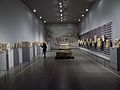 Interior of theŞanlıurfa Museum
 -
 Interior of the Haleplibahçe Mosaic Museum
 -
 Gölbaşı-Garden
 -
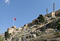 Ruins of Urfa castle
 -
 Urfa Armenian Protestant church
 -
 Ayn Zeliha
 -
 The museum complex, viewed from the south: in the foreground is the Haleplibahçe Mosaic Museum; in the background is theŞanlıurfa Museum.
 -
 Euphrates River
 -
![Surrounding fields of Göbekli Tepe, the site of the oldest temple in the world.[3]](//upload.wikimedia.org/wikipedia/commons/thumb/c/c8/G%C3%B6bekli_Tepe_surrounding_area.JPG/120px-G%C3%B6bekli_Tepe_surrounding_area.JPG) Surrounding fields of Göbekli Tepe, the site of the oldest temple in the world.[3]
Surrounding fields of Göbekli Tepe, the site of the oldest temple in the world.[3]


![Surrounding fields of Göbekli Tepe, the site of the oldest temple in the world.[3]](/File:G%C3%B6bekli_Tepe_surrounding_area.JPG)
Religious significance
According to some
For the Armenians, Urfa has "great symbolic value" since it is believed that the Armenian alphabet was invented there.[50]
Politics

Urfa is a stronghold of the governing Justice and Development Party and is sometimes called a "vote depot" for the party.[51][52]
From 2004 to 2014, Ahmet Eşref Fakıbaba served as mayor of Urfa for two terms.[51] A popular figure in Urfa politics, Fakıbaba first rose to prominence as Chief Physician at the Şanlıurfa SSK Hospital, a role which he held for 11 years.[51] In 2004 he ran as the AKP candidate in the mayoral election and won.[51] The AKP did not nominate Fakıbaba as their mayoral candidate in the 2009 local elections, saying that they had 70% of the vote in Urfa and could win the election if their candidate was a jacket.[51] However, Fakıbaba ran as an independent and won reelection to a second term.[51] He later joined the Felicity Party before rejoining the AKP in 2013.[51] In 2015, Fakıbaba was elected to the National Assembly as an AKP member, replacing previous Urfa MP Faruk Çelik.[51] He later resigned as MP in 2022.[51]
Demographics
History
The ethnic and religious demographics of the city have shifted over the centuries and were largely diverse. In ancient times, the region was mixed with Greeks, Arabs, Syrians, and Armenians.[7] At the time of the First Crusade, the majority of the population were either Armenian or Assyrian.
There was an ancient Jewish community in Urfa, with about 1,000 people by the 19th century. Most of them emigrated in 1896, fleeing the Hamidian massacres, and settling mainly in Aleppo, Tiberias and Jerusalem.[53] In 1910, Ely Bannister Soane wrote that apart from Turkish effendis, Urfa was populated by Arabs, Kurds and a large number of Armenians.[54] British forces reported a mixed pre-war population of Kurds, Turks and 7,500 Armenians.[55] The Armenian Patriarchate of Constantinople reported 25,000 to 30,000 Armenians in Urfa and its environs, on an overall population of 60,000.[53] According to Agha Petros, there were 7,200 Syriacs in the city of Urfa, and 8,000 in ten surrounding villages.[53] Joseph Tfinkdji reports 200 Chaldeans.[53] According to 1918 reports of the Urfa mutasarrifate, there were 33,000 Turks, 27,000 Kurds, 12,000 Arabs, 5,500 Armenians, 3,000 Assyrians, and 500 Jews in the central kaza.[56]
The Armenian and Assyrian Genocides, undertaken by Ottoman troops and Ottoman-sponsored militias such as the special organization,[57] led to the slaughter, deportation,[55] and ethnic cleansing of much of the Christian population of Urfa and the surrounding region. Following the establishment of the Republic of Turkey, most of the remaining non-Muslim population left the city due to continued persecution.[58]
Language
In the early 19th century, the dominant language of the city was Turkish,[59] while Armenian, Syriac, Kurdish, Arabic, and Persian were also spoken. Armenians were observed to speak Turkish to strangers, while Assyrians spoke Arabic.[7]
Present-day
Today, the city is mainly composed of Arabs and Kurds[60][61] as well as Turks.[62]
Syrian refugees
Since the outbreak of the
In general, Syrians in Urfa have clustered in areas where home rental prices are lower; typical rents range from 600 to 900 liras (as of 2019).
Syrian refugees in Urfa often struggle with financial difficulties and unemployment.[42]: 122 The language barrier hinders integration into the surrounding community, and many Syrians tend to form their own communities and interact less with Turkish locals.[42]: 122 Many Syrians in Urfa run their own businesses; workplaces belonging to Syrian refugees are clustered around Şehit Nusret Caddesi and Atatürk Boulevard, Sarayönü and Divanyolu Streets, and Haşimiye Meydan.[42]: 122 Many Syrians are also self-employed as street vendors, selling food, clothes, toys, and other items.[63]
Before 2017, relations were relatively friendly between Syrians and Turks, but after 2017 relations began to deteriorate as there was a growing perception among Turks that Syrians were to blame for economic stagnation.[42]: 122 The rapid increase in Syrian-owned businesses in Urfa, depressed wages for workers, and a perception that Syrians are "cheap labor" have all contributed to anti-Syrian sentiment among Turks.[42]: 121 Some Turks also resent the fact that Syrian refugees have free access to healthcare and education.[42]: 112 In July 2019, local authorities removed all Arabic-language signs on Syrian-owned businesses in Urfa and made Turkish-language signs mandatory.[42]: 122
Economy


As of 2018, the average per capita income in Urfa is $4,400 USD per year.[66] As of 2018, unemployment in Urfa is 18%, among young people it is 35%.[66]
Urfa is a center of footwear production in the region,[66] and around 5,000 people are employed in this sector.[67]: 15 The Istanbul-based shoe retailer FLO, owned by the Ziylan Group, opened a shoe factory in Urfa in 2012.[68] As of 2018, this factory employed 900 people and was the largest footwear factory in the region,[66] producing 1.8 million pairs of shoes per year.[69] FLO was planning to open a second factory, employing 1,500 more people, in the city in early 2019.[66] According to the province governor Abdullah Erin, there were also plans to open some 13 more shoe factories in the Organized Industrial Zone by 2023, employing as many as 20,000 people and producing 30 million pairs of shoes annually.[66]
Urfa is a major producer of pistachio nuts, with 29.7 million trees in the whole province producing 38,576 tons of pistachios in 2021.[70] However, most processing is done in Gaziantep, which is the other main pistachio producer in Turkey.[70] Both cities' pistachios have geographical indications under different names for different cultivars, with Urfa's officially known as the "Urfa flax village pistachio" (Urfa keten köyneği fıstığı).[70]
Handicrafts
Urfa has a rich tradition of
Copper-smithing is relatively prosperous among Urfa's handicrafts, although demand has fallen in favor of more contemporary décor.
Artisanal leather tanning, on the other hand, is no longer practiced in Urfa, and new apprentices are not taught.[71]: 371 Professionals now send the hides to industrial-scale leather factories instead.[71]: 371 Commercial production of handmade embroidery has also ceased in Urfa, although many women continue the craft for dowry purposes.[71]: 369
Limestone quarrying

There is an abundance of limestone in the Urfa area, and it has been quarried extensively since ancient times for use as a building material.[72]: 1–3, 5–7 This limestone, known as Urfa limestone, was mostly deposited in Eocene through Miocene times (about 56-5 million years ago).[72]: 8 It has a light, whitish-yellow ochre color.[72]: 3, 10 When freshly extracted from the quarry and still rather moist, Urfa limestone is relatively soft and can easily be cut with a handheld saw.[73]: 489–90 Once exposed to the atmosphere, though, its surface gradually hardens so that it makes a suitably strong building material.[73]: 490
Urfa limestone has been quarried for human use since at least the Neolithic period: it was the main building material used at Göbekli Tepe, 12,000 years ago, and the prehistoric quarries and workshops at Göbekli Tepe are among the oldest in the world.[72]: 2–3, 8 On the southern edge of the rocky plateau, there are also traces of quarries dating back to ancient Roman times.[72] : 8–9 Many old quarries in the area were also dug underground, forming artificial caves.[72]: 5 The oldest of this type is the massive 4-story Basda quarry, although its precise age is unknown.[72]: 9
A number of active limestone quarries exist today in the Urfa area.[72]: 7–8 Much of the quarrying is done just west of the city, around the Evren Industrial Estate. [74]: 163 Şanlıurfa province's total limestone reserves amount to 62.2 million tons, and its industry has an annual processing capacity of 31,680 tons.[72]: 8 Many of the stone blocks quarried from the Urfa area are sent to Mardin and Midyat for processing.[72]: 5
Before the introduction of
Industrial zones
Organized Industrial Zone
The Organized Industrial Zone (Turkish: Organize Sanayi Bölgesi) is located 17 km west of central Urfa on the highway to Gaziantep.[75] Construction started in 1991.[75] The site consists of three areas covering over 1,700 hectares as of 2018.[75] It is home to about 250 companies and employs about 13,000 people.[75]
Evren Industrial Estate
The Evren Industrial Estate (Turkish: Evren Sanayi Sitesi) is a Small Industrial Site located about 7 km west of central Urfa on the highway to Gaziantep.[76] It covers about 140 hectares and is home to about 1500 businesses.[76] It became operational in 1994.[76] Urfa's limestone quarries are also clustered around here.[74]: 163
Culture
Cuisine

As the city of Urfa is deeply rooted in history, so its unique cuisine is an amalgamation of the cuisines of the many civilizations that have ruled in Urfa . It is widely believed that Urfa is the birthplace of many dishes, including Çiğ köfte, that according to the legend, was crafted by the Prophet Abraham from ingredients he had at hand.[77]
Meat-based dishes are a staple of everyday meals in Urfa.[78]: 85 There is a local saying, "There is no trouble where meat comes in" (Turkish: et giren yere dert girmez).[78]: 85 Foods like lahmacun and kebab are consumed daily by many people.[78]: 85 Ciğer kebabı, or liver kebab, is especially popular among poorer Urfalis, since liver is usually a relatively cheap meat.[79] Liver kebab is popularly eaten for either breakfast, lunch, or dinner.[79]
The walnut-stuffed Turkish dessert crepe (called şıllık) is a regional specialty.[80] According to legend, its sweet syrup was first made using molasses from the Hanging Gardens of Babylon.[78]: 86
Hospitality
Urfali society traditionally places a great value on hospitality, and inviting guests over and sharing food with them has a special importance.[78]: 86 Locals attribute this to the prophet Abraham, who according to legend never dined alone — he always had guests over to share his meals with.[78]: 86 The locally common epithet "Halil İbrahim Sofrası" ("the tablecloth-like") depicts this characterization.[78]: 86
Literature
Urfa has a long history of literature, going back to early Christian writers such as
Traditional house architecture

Urfa's old town has many old courtyard houses; many were built during a construction boom in the 19th century.

An important consideration in domestic architecture is mahremiyat, which could roughly be translated into English as "privacy" or "intimacy" but which carries stronger implications.[82]: 313 This concept is especially important when it comes to relations between men and women – outside the extended family, interaction between men and women is restricted.[82]: 313 As a result, traditional Urfa houses are constructed in ways to prevent men outside from viewing the women of the household.[82]: 319–20 For example, doors facing each other, windows facing the street, and significant differences in roof elevation are all avoided.[82]: 313
Local Turkish dialect
The Turkish spoken in Urfa has some features in common with the variety of Iraqi Turkmen spoken in Kirkuk, as well as some features owed to Arabic influence.[10]: 19 For example, the Arabic sounds 'ayn, ghayn, and qāf are pronounced the same in Urfa as they are in Arabic, which is not done in standard Turkish.[10]: 19
Education
Harran University
Harran University was established in Urfa in 1992 as an amalgamation of several different faculties that had previously been attached to two different universities.[83]
Former vocational schools
Mekteb-i Sanayi
By 1906, the presence of a vocational school in Urfa called the Mekteb-i Sanayi is attested.
Urfa Girls' Institute
The Urfa Girls' Institute (Turkish: Urfa Kız Enstıtüsü), which opened in 1942, was an early vocational school teaching practical trades and general subjects to girls and young women.[85]: 421
Urfa Institute of Art for Boys
The boys' equivalent to the Girls' Institute was Urfa Institute of Art for Boys (Turkish: Urfa Erkek Sanat Enstıtüsü), which provided vocational education to boys aged 12 to 17.[84]: 187
Health
Old state hospital
The old state hospital in Urfa was established by Ethem Bey in 1903 and became a public hospital in 1943.[86] This hospital eventually came to comprise four different buildings, serving as the A, B, C, and D blocks.[86] The A-block building, which was three stories tall, opened in 1962 and was originally dedicated to treatment of tuberculosis.[86] The B-block building opened in 1972 and had 200 beds.[86] The D block was for emergency care.[86] Demolition of the old state hospital, which was located in Atatürk mahalle of Haliliye district, was completed in 2022.[87] At the time of the demolition, the provincial health directorate was planning to build a new 150-bed children's hospital on the site.[87]
Şanlıurfa Balıklıgöl State Hospital
The Şanlıurfa Balıklıgöl State Hospital (Şanlıurfa Balıklıgöl Devlet Hastanesi) was established in 1963 as a "Health Station" (Sağlık İstasyonu), and then became a dispensary in 1975.[88] In July 1983, it became the Şanlıurfa SSK Hastanesi and was operating as an inpatient facility with 150 beds.[88] In addition, a 5-story outpatient department building began construction in 1991 and then became operational in 1994.[88] It was renamed in 2005 to its current name.[88]
Şanlıurfa Training and Research Hospital
The Training and Research Hospital (Şanlıurfa Eğitim Ve Araştırma Hastanesi) was established in 1973 with 125 beds.[89] Originally, it was a branch hospital under the State Hospital, until 1984.[89] From 1984 until 2004, it was a gynecology and pediatric hospital, and in 2004 it was split in two: the gynecology and obstetric hospital, which remained in the same building, and the pediatric hospital, which moved into the old State Hospital building.[89] In 2016, the two branch hospitals were combined together into the Training and Research Hospital in the current building due to a shortage of beds.[89] The current building, as of 2019, covers over 100,000 square meters and has 400 patient rooms (with separate beds and restrooms), 18 operating rooms (2 of which are set aside for "maternity emergencies"), a 180-person conference hall, and an 80-person training hall, as well as a helipad and a parking lot with 1,200 spaces.[89] The hospital covers gynecology, pediatric, and adult healthcare.[89]
Mehmet Akif İnan Training and Research Hospital
The Mehmet Akif İnan Training and Research Hospital (Mehmet Akif İnan Eğitim ve Araştırma Hastanesi) opened in 2004 and handles as many as 3,500 to 6,000 patient applicants per day.[86] It has 500 beds (rooms have 1, 2, or 3 beds, as well as their own restrooms) and a conference hall that can seat 156 people.[86] There is a blood center, a dialysis unit, and an intensive care unit, as well as a physical therapy unit for outpatients.[86]
Transport

Şanlıurfa GAP Airport is located about 34 km (21 mi) northeast of the city and has direct flights to Istanbul, Ankara and Izmir. The main highway from Gaziantep to Diyarbakır now bypasses Urfa on the northwest.[11]: 8
Construction of the first phase of a planned four-route, 78 km network of
See also
- Cilicia War
- Urfa Resistance
- Chronology of the Turkish War of Independence
- Cities of the ancient Near East
- Haliliye
- Karaköprü
- Göbekli Tepe
- Ur of the Chaldees in southern Iraq, also claimed as the birthplace of Abraham
Notes
- al-Sayrafi, 17 November; according to the anonymous Chronicle of Bar Hebraeus, 23 November.[23]: 60
- ^ Armenian-Genocide.org presents a somewhat different timeline: according to them, the first killings happened on 19 August, when about 250 Armenians were killed, and the second round happened four days later on 23 August.[39]
References
- ^ a b "'City of prophets' drawing faith tourists". Hürriyet Daily News. 20 November 2014. Retrieved 29 October 2020.
- ^ "Şanlıurfa". citypopulation.de. Retrieved 10 January 2024.
- ^ a b c "The World's First Temple – Archaeology Magazine Archive". archive.archaeology.org. Retrieved 22 March 2018.
- ^ ISBN 1-884964-02-8. Retrieved 3 October 2022.
- ^ a b "The secret Jews of remote Turkey". Jewish Telegraph Agency. 4 March 2003. Retrieved 4 October 2022.
- ^ ISBN 9780822372455. Retrieved 4 October 2022.
- ^ a b c The Oriental Herald, and Journal of General Literature Vol. XII. London. 1827. pp. 39, 40, 47, 48. Retrieved 9 September 2022.
- ^ Avcıkıran, Adem (2009). Kürtçe Anamnez Anamneza bi Kurmancî (in Turkish and Kurdish). p. 57.
- ISBN 0-86078-395-2.
- ^ ISBN 978-975-8165-40-7. Retrieved 28 December 2022.
- ^ ISBN 0-907132-52-9. Retrieved 20 March 2022.
- ^ "Resmi İstatistikler: İllerimize Ait Mevism Normalleri (1991–2020)" (in Turkish). Turkish State Meteorological Service. Retrieved 7 August 2021.
- ^ "World Meteorological Organization Climate Normals for 1991–2020". World Meteorological Organization. Retrieved 2 August 2023.
- ISBN 9781107082731.
- ^ ISBN 978-0-8091-0544-1.
- ISBN 0-9713097-1-X.
It is certainly surprising that no obvious reference to Orhay has been found so far in the early historical texts dealing with the region, and that, unlike Harran, its name does not occur in cuneiform itineraries. This may be accidental, or Orhay may be alluded to under a different name which has not been identified. Perhaps it was not fortified, and therefore at this time a place of no great military significance. With the Seleucid period, however, we are on firm historical ground. Seleucus I founded—or rather re-founded—a number of cities in the region. Among them, probably in 303 or 302 BC, was Orhay.
- ^ ISBN 978-975-585-992-7. Retrieved 8 November 2022.
- ^ a b Çelik, Bahattin (2014). "Şanlıurfa – Yeni Mahalle Höyüğü in the Light of Novel C14 Analysis". In Engin, Atilla; Helwing, Barbara; Uysal, Bora (eds.). Armizzi: Engin Özgen Armağan. Asitan Kitap. pp. 101–7. Retrieved 7 November 2022.
- ISBN 978-1-57607-862-4.
- ISBN 978-1-68235-601-2. Retrieved 22 September 2023.
- ^ ISBN 0-415-11376-8. Retrieved 4 November 2022.
- ^ a b c d e f g h i j k l m n Lieu, Samuel (1997). "Edessa". Encyclopaedia Iranica. Vol. 8. pp. 174–175.
- ^ ISBN 978-1-78969-757-5. Retrieved 1 October 2022.
- ^ S2CID 162707445. Retrieved 21 December 2022.
- ^ ISBN 90-04-09834-8. Retrieved 27 October 2022.
- ^ ISBN 0-299-04834-9. Retrieved 29 September 2022.
- ^ a b c d e Amouroux-Mourad, Monique (1988). Le comté d'Edesse, 1098–1150. Paul Guethner.
- ^ ISBN 0-299-04834-9.
- ^ Nicholson, Robert Lawrence (1973). Joscelyn III and the Fall of the Crusader States, 1134–1199. Leiden: E. J. Brill.
- ^ Runciman, Steven (1952). A History of the Crusades, Volume II: The Kingdom of Jerusalem and the Frankish East. Cambridge: Cambridge University Press.
- ISBN 978-90-04-09896-1.
- ISBN 9780520228924. Retrieved 23 February 2023.
- ^ S2CID 163430587. Retrieved 16 November 2022.
- ^ ISBN 978-605-281-528-1. Retrieved 3 October 2022.
- ISBN 0-688-08093-6.
- Jewish Encyclopedia. 1906.
- ^ "Interview with Harun Bozo". The Library of Rescued Memories. Central Europe Center for Research and Documentation.
- ISBN 0-87395-612-5.
- ^ a b c d e "Chronology of the Armenian Genocide – 1915 (July–September)". Armenian-Genocide.org. Retrieved 23 February 2023.
- ^ ISBN 9780805086652. Retrieved 23 February 2023.
- ^ Original text of the Treaty of Sèvres (PDF). 1920. Archived from the original (PDF) on 31 May 2014. Retrieved 28 December 2022.
- ^ S2CID 212768026. Retrieved 30 November 2022.
- ^ a b "How do Syrians live in the Turkish city of Urfa amid "extremism"?". Enab Baladi. 29 May 2016. Retrieved 30 November 2022.
- ^ ISBN 9781848368460. Retrieved 3 October 2022.
- ^ a b c d Ertuğrul, Erman (2015). "Urfa'da Haleplibahçe Müze Kompleksi Açıldı" (Web). Arkeofili. Retrieved 30 November 2022.
- ^ a b c d e "Şanlıurfa Museum". müze.gov.tr. Retrieved 30 November 2022.
- ^ a b c d e f g Şenol, Halil İbrahim; Memduhoğlu, Abdulkadir; Ulukavak, Mustafa (2020). "Multi instrumental documentation and 3D modelling of an archaeological site: a case study in Kizilkoyun Necropolis Area". Dicle University Journal of Engineering. 11 (3): 1241–50. Retrieved 2 March 2023.
- ^ a b c d e f g h i j Fidan, Halil (2018). "Şanlıurfa'da huzurlu alışverişin adresi: Tarihi Kapalı Çarşı". Anadolu Agency. Retrieved 4 October 2022.
- ^ a b "Mesire alanındaki çalışmalarda sona yaklaşıldı!". Urfanatik. 22 December 2022. Retrieved 23 December 2022.
- ^ Öktem, Kerem (2003). Creating the Turk's Homeland: Modernization, Nationalism and Geography in Southeast Turkey in the late 19th and 20th Centuries (PDF). Harvard: University of Oxford, School of Geography and the Environment, Mansfield Road, Oxford, OX1 3TB, UK. Archived from the original (PDF) on 9 November 2013. Retrieved 19 January 2013.
For Armenians, the city has a great symbolic value, as the Armenian alphabet was invented there, thanks to a group of scholars and clergy headed by Mesrop Mashtots in the 5th century
- ^ a b c d e f g h i Aksan, Cengiz (22 October 2022). "FAKIBABA, SIFIRI MI TÜKETTİ SIFIRDAN MI BAŞLIYOR?". Ajans Urfa. Retrieved 23 December 2022.
- ^ "Erdoğan'a 'AKP'nin oy deposu' olan dört ilden kötü haber: Kaleleri birer birer düşüyor!". Gerçek Gündem. 22 October 2022. Retrieved 23 December 2022.
- ^ a b c d "Kaza of Urfa / ܐܘܪܗܝ - Urhoy / Ուռհա - Urha / Ἔδεσσα - Edessa". Virtual Genocide Memorial. Retrieved 16 September 2023.
- ^ Soane, Ely Bannister (1910). To Mesopotamia and Kurdistan in Disguise. pp. 46–47.
- ^ a b Military Report on Mesopotamia (Iraq). 1923. p. 17. Retrieved 28 October 2022.
- ^ Aslan, Ahmet. "URFA'DA ASAYİŞ VE GÜVENLİK (1913–1918)" (PDF). İstanbul Üniversitesi. Retrieved 7 June 2022.
- ^ Bloxham, Donald (2003). "The Armenian Genocide of 1915–1916: Cumulative Radicalization and the Development of a Destruction Policy". Past & Present. 181 (181): 141–191.
- ^ Biner, Zerrin Özlem (2019), p371. States of Dispossession: Violence and Precarious Coexistence in Southeast Turkey
- ^ London Magazine, Volume 7. London. 1827. p. 546. Retrieved 9 September 2022.
- ISBN 9780367729233.
- ^ Muslu, Olcay (2022). "UNESCO-Based and UNESCO-Free: Governmental and Non-Governmental Efforts for Safeguarding Intangible Cultural Heritage in Turkey". In Schippers, Huib; Seeger, Anthony (eds.). Music, Communities, Sustainability: Developing Policies and Practices. Oxford University Press. p. 124.
- ISBN 978-0-19-534770-8. Retrieved 28 October 2022.
- ^ a b "Ramadan Sidewalk Merchandise Displays: Job Opportunities for Syrians in Urfa". Enab Baladi. 21 June 2017. Retrieved 30 November 2022.
- ^ a b Situation Report: An Assessment of Syrian Refugees in Şanlıurfa Province. Hayata Destek. 2014. Retrieved 30 November 2022.
- ^ ""Tarahum 2" Community Opens its Doors in the Turkish City of Urfa". Enab Baladi. 9 October 2017. Retrieved 30 November 2022.
- ^ a b c d e f Ergu, Elif (2018). "Urfa ayakkabı üssü oluyor". Hürriyet. Retrieved 29 November 2022.
- ^ Orange – MEAL Department (2021). Labor Market Assessment and Mapping of Şanliurfa (COVID-19 Integration with Needs) Key Findings Report. Retrieved 29 November 2022.
- ^ Ertan, Serhat (2021). 51 Company Book – SHOE AND SHOE SIDE INDUSTRY. ERP Destekli Bütçe Danışmanlığı A.Ş. pp. 652–3. Retrieved 29 November 2022.
- ^ "Şanlıurfa FLO'nun üretim üssü olacak". Türkiye. 23 November 2016. Retrieved 30 November 2022.
- ^ a b c Ayaydın, Eşber (10 June 2022). "Gaziantep ve Şanlıurfa arasında ismi paylaşılamayan lezzet: Fıstık". Anadolu Agency. Retrieved 24 December 2022.
- ^ a b c d e f g h i j k l Akpınarlı, H. Feriha; Uluişik, Yaprak Pelin (2021). "Yerel Kalkınmada Halk Kültürü Projelerinin Önemi "Şanlıurfa Örneği"". Uluslararası Kazan Halk Kültürü Sempozyumu. 4: 365–72. Retrieved 23 January 2023.
- ^ S2CID 221674298. Retrieved 16 February 2023.
- ^ S2CID 1715021. Retrieved 16 February 2023.
- ^ doi:10.22520/tubaked.2004-2.0007 (inactive 31 January 2024). Retrieved 18 February 2023.)
{{cite journal}}: CS1 maint: DOI inactive as of January 2024 (link - ^ a b c d "Organize Sanayi Bölgesi I. Kısım". investsanliurfa.com. Yatirim Destek Ofısı Şanlıurfa. 2018. Retrieved 27 November 2022.
- ^ a b c "KSS'ler". investsanliurfa.com. Yatirim Destek Ofısı Şanlıurfa. 2018. Retrieved 27 November 2022.
- ISBN 978-605-106-065-1
- ^ a b c d e f g Aksoy, Mustafa; Sezgi, Gülistan (2015). "Gastronomi turizmi ve Güneydoğu Anadolu Bölgesi gastronomik unsurları" (PDF). Journal of Tourism and Gastronomy Studies. 3 (3): 79–89. Retrieved 26 December 2022.
- ^ a b "Yoksul yemeği lüks tüketim oldu". Ajans Urfa. 15 December 2022. Retrieved 27 December 2022.
- ^ "Şanlıurfa'nın 'şıllık' tatlısı tescillendi". Sabah. Retrieved 8 November 2018.
- JSTOR 1006137. Retrieved 28 December 2022.
- ^ JSTOR 44987208. Retrieved 30 November 2022.
- ^ "Tarihçemiz". Harran Üniversitesi. Retrieved 1 December 2022.
- ^ ISSN 1307-9581. Retrieved 3 December 2022.
- ISSN 1307-9581. Retrieved 3 December 2022.
- ^ a b c d e f g h "Tarihçemiz". Şanlıurfa Mehmet Akif İnan Eğitim Ve Araştırma Hastanesi. Şanlıurfa İl Sağlık Müdürlüğü. Retrieved 23 December 2022.
- ^ a b "Urfa'da tamamen yıkılan eski devlet hastanesi yerine ne yapılacak?". Ajans Urfa. 29 June 2022. Retrieved 23 December 2022.
- ^ a b c d "Tarihçemiz". Şanlıurfa Balıklıgöl Devlet Hastanesi. Şanlıurfa İl Sağlik Müdürlüğü. Retrieved 23 December 2022.
- ^ a b c d e f "Tarihçe". Şanlıurfa Eğitim Ve Araştırma Hastanesi. Şanlıurfa İl Sağlık Müdürlüğü. Retrieved 23 December 2022.
- OCLC 62554332.
- ISSN 0266-7452.
- ISSN 0266-7452.
- ISSN 0266-7452.
- OCLC 62554332.
- ^ OCLC 62554332.