
Uxmal
This article includes a list of general references, but it lacks sufficient corresponding inline citations. (April 2009) |
Yucatán | |
| Coordinates | 20°21′34″N 89°46′17″W / 20.35944°N 89.77139°W |
|---|---|
| History | |
| Founded | 700 AD |
| Periods | Late Classic to Terminal Classic. |
| Cultures | Maya civilization |
| Site notes | |
| Official name | Pre-Hispanic Town of Uxmal |
| Criteria | Cultural: i, ii, iii |
| Reference | 791 |
| Inscription | 1996 (20th Session) |
Uxmal (
Uxmal is located 62 km south of Mérida, capital of Yucatán state in Mexico. Its buildings are noted for their size and decoration. Ancient roads called sacbes connect the buildings, and also were built to other cities in the area such as Chichén Itzá in modern-day Mexico, Caracol and Xunantunich in modern-day Belize, and Tikal in modern-day Guatemala.
Its buildings are typical of the
The buildings take advantage of the terrain to gain height and acquire important volumes, including the Pyramid of the Magician, with five levels, and the Governor's Palace, which covers an area of more than 1,200 m2 (12,917 sq ft).
Toponymy
The present name seems to derive from Oxmal, meaning "three times built." This seems to refer to the site's antiquity and the times it had to rebuild. The etymology is disputed; another possibility is Uchmal which means "what is to come, the future." By tradition, this was supposed to be an "invisible city," built in one night by the magic of the dwarf king.
Maya legend

The Maya legend The Dwarf-Wizard of Uxmal is set in Uxmal.[1]
Description of the site
.jpg)
Some of the more noteworthy buildings include:
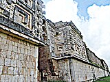
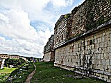
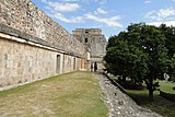
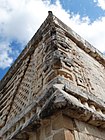
- The Governor's Palace, a long low building atop a huge platform, with the longest façades in Pre-Columbian Mesoamerica.
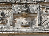
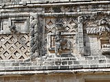
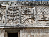
- With an approximate azimuth of 118°, the building is oriented to the main pyramid of Cehtzuc, a small site located nearly 5 km to the southeast. Observing from there, Venus as evening star, when reaching its maximum northerly extremes, would have set behind the northern edge of the Governor's Palace.[2] Since these events occur every eight years, always in late April or early May, heralding the onset of the rainy season,[3] it is significant that the decoration of the building's facade contains almost 400 Venus glyphs placed in the masks of the rain god Chac, and that there are eight bicephalic serpents above the main entrance; additionally, numerals 8 in bar-and-dot notation appear on two Chac masks at the northern corners of the palace.[4]
-
 Governor's Palace details
 -
 Governor's Palace rear view and details
 -
 Governor's Palace rear view
 -
 Governor's Palace side view
 -
 Throne of the Jaguar
 -
 Nunnery Quadrangle and the Pyramid of the Magician
 -
 Traditional Mayan symbols
 -
 Maya images of people and animals
 -
 Snake and traditional Mayan lattice
 -
 Sculptural image on the corner of the building
 -
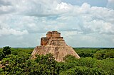 View of the pyramid and the surrounding jungle


.jpg)


- The Adivino (a.k.a. the stepped pyramidstructure, unusual among Maya structures in that its layers' outlines are oval or elliptical in shape, instead of the more common rectilinear plan. It was a common practice in Mesoamerica to build new temple pyramids atop older ones, but here a newer pyramid was built centered slightly to the east of the older pyramid, so that on the west side the temple atop the old pyramid is preserved, with the newer temple above it.
The structure is featured in one of the best-known tales of Yucatec Maya folklore, "el enano del Uxmal" (the dwarf of Uxmal), which is also the basis for the structure's common name. Multiple versions of this tale are recorded. It was popularised after one of these was recounted by
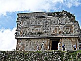
- The Nunnery Quadrangle was built from 900-1000, and the name related with nuns was assigned in the 16th century because it resembled a convent. The quadrangle consists of four palaces placed on different levels that surround a courtyard. Of the different buildings that make up this palatial complex, several vault tops have been recovered, they are painted and represent partial calendrical dates from 906 to 907 AD, which is consistent with the Chan Chahk’ahk Nalajaw period of government. The formal entrance, the hierarchy of the structures through the different elevations, and the absence of domestic elements suggest that this space corresponds to a royal palace with administrative and non-residential functions, where the ruling group must have had meetings to collect the tribute, make decisions, and dictate sentences among other activities.[6] These set of buildings are the finest of Uxmal's several fine quadrangles of long buildings. It has elaborately carved façades on both the inside and outside faces.
- A large Ballcourt for playing the glyphs). The ball court's condition is very deteriorated, and it’s made of two constructions of medium dimensions that make up the sides of the court with the rings by which the ball was to be introduced. The originally carved stone rings were removed to protect them from the elements and were replaced by reproductions. This game has always been related to mythical and cosmic aspects. The ball symbolized the movements of the stars in the sky and the players, in repeated occasions, symbolically staged the fight of the day against the night or the struggle of the deities of the underworld against the gods of heaven.[7]
_SLOW_-_001.jpg)
Modern history of the ruins

Queen
Microbial degradation
Microbial
See also
- List of archaeoastronomical sites sorted by country
- List of Mesoamerican pyramids
References
- ISBN 9780835237604.
- ISBN 9788492509560.
- S2CID 118585661.
- ISBN 9781461461425.
- OCLC 863468.
- ^ "The Nunnery Quadrangle in Uxmal". mayanpeninsula.com. 2018-10-03. Retrieved 2021-05-12.
- ^ "The Mayan Ball Court in Uxmal". mayanpeninsula.com. 2018-10-04. Retrieved 2021-05-12.
- ^ SÁNCHEZ, LUIS CARLOS (2014-09-01). "Pelean por los derechos de Uxmal" (in Spanish). excelsior.com.mx. Retrieved 2021-05-12.
- S2CID 25345460.
- ISBN 9781560229711.
