Vaigai River
| Vaigai River | |
|---|---|
 | |
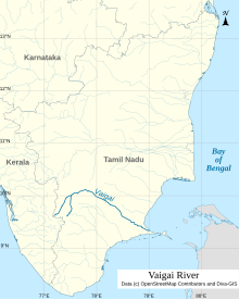
 Map of Vaigai river | |
| Etymology | … |
| Location | |
| Country | India |
| . | |
| Physical characteristics | |
| Source | Varusanadu Hills |
| • location | Tamil Nadu, India |
| Mouth | |
• location | Palk Bay, India |
• elevation | 0 m (0 ft) |
| Length | 258 km (160 mi) |
| Discharge | |
| • average | 36 m3/s (1,300 cu ft/s) |
| Discharge | |
| • location | Peranai[1] |
| • average | 28.8 m3/s (1,020 cu ft/s) |
Vaigai River | ||||||||||||||||||||||||||||||||||||||||||||||||||||||||||||||||||||||||||||||||||||||||||||||||||||||||||||||||||||||||||||||||||||||||||||||||||||||||||||||||||||||||||||||||||||||||||||||||||||||||||||||||||||||||||||||||
|---|---|---|---|---|---|---|---|---|---|---|---|---|---|---|---|---|---|---|---|---|---|---|---|---|---|---|---|---|---|---|---|---|---|---|---|---|---|---|---|---|---|---|---|---|---|---|---|---|---|---|---|---|---|---|---|---|---|---|---|---|---|---|---|---|---|---|---|---|---|---|---|---|---|---|---|---|---|---|---|---|---|---|---|---|---|---|---|---|---|---|---|---|---|---|---|---|---|---|---|---|---|---|---|---|---|---|---|---|---|---|---|---|---|---|---|---|---|---|---|---|---|---|---|---|---|---|---|---|---|---|---|---|---|---|---|---|---|---|---|---|---|---|---|---|---|---|---|---|---|---|---|---|---|---|---|---|---|---|---|---|---|---|---|---|---|---|---|---|---|---|---|---|---|---|---|---|---|---|---|---|---|---|---|---|---|---|---|---|---|---|---|---|---|---|---|---|---|---|---|---|---|---|---|---|---|---|---|---|---|---|---|---|---|---|---|---|---|---|---|---|---|---|---|---|
| ||||||||||||||||||||||||||||||||||||||||||||||||||||||||||||||||||||||||||||||||||||||||||||||||||||||||||||||||||||||||||||||||||||||||||||||||||||||||||||||||||||||||||||||||||||||||||||||||||||||||||||||||||||||||||||||||
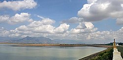
The Vaigai is a river in the Tamil Nadu state of southern India; it passes through the towns of Theni, Madurai and Ramanathapuram.[2] It originates in Varusanadu Hills, the Periyar Plateau of the Western Ghats range, and flows northeast through the Kambam Valley, which lies between the Palani Hills to the north and the Varushanad Hills to the south. The Vattaparai Falls are located on this river. As it rounds the eastern corner of the Varushanad Hills, the river turns southeast, running through the region of Pandya Nadu. Madurai, the largest city in the Pandya Nadu region and its ancient capital, lies on the Vaigai. The river empties into the Palk Bay near Alagankulam, close to Pamban Bridge in Ramanathapuram District.
The Vaigai is 258 kilometres (160 mi) long, with a drainage basin 7,031 square kilometres (2,715 sq mi) large.[3] This river flows through 5 districts namely Theni, Dindigul, Madurai, Sivagangai and Ramanathapuram and this river Serves as a Lifeline for 6 districts namely Theni, Dindigul, Madurai, Sivagangai, Virudhunagar and Ramanathapuram as farmers of all these districts are greatly depends on this river water.
Vaigai in literature
Sangam literature (circa 300 BCE to 300 CE[4][5][6]) has paid many tributes to Vaigai, extolling it as 'the river that brings water when one touches it', viz the etymology Vai (Earth) + yai (sky) = Vaiyai .[7][8]
The following story is told about the birth of the river Vaigai. Koodal Purana details the origin of Vaigai river flowing through
Tributaries
The main tributaries of the Vaigai are Siruliar, Theniar, Varaha Nadi, and Mangalar.[10] Vaigai Dam is the major dam in this river which is present in Theni district.[citation needed]
Vaigai gets major feed from the Periyar Dam in Kumili, Kerala. Water from the Periyar River in Kerala is diverted into the Vaigai River in Tamil Nadu via a tunnel through the Western Ghats. In summers, the Vaigai river ends up dry very often. The water never reaches Madurai, let alone flowing into places past Madurai.[citation needed]
Dams

The Vaigai Dam is built across the river in
The
See also
References
- ^ "Gauging Station – Data Summary". ORNL. Retrieved 1 October 2013.
- ^ Madurai, Temple Town of South India. Cultural capital of Tamilnadu
- ISBN 978-81-7008-068-8. Retrieved 16 May 2011.
- ISBN 978-81-317-1120-0.
- ISBN 978-81-208-1215-4.
- ISBN 978-1-5381-0686-0.)
{{cite book}}: CS1 maint: multiple names: authors list (link - ^ a b c M., Rajagopalan (1993). 15 Vaishnava Temples of Tamil Nadu. Chennai, India: Govindaswamy Printers. pp. 119–128.
- ^ a b c S., Sundararajan (6 September 2004). "Symbol of togetherness". The Hindu. Archived from the original on 27 November 2004. Retrieved 29 October 2015.
- ISBN 978-81-8475-694-4.
- ^ "Vaigai River | Map, India, & Tributaries | Britannica". www.britannica.com. 18 August 2023. Retrieved 10 September 2023.
- ^ "Water released from Vaigai dam for irrigation". The Hindu. Archived from the original on 25 November 2020. Retrieved 9 August 2007.
{{cite web}}: CS1 maint: unfit URL (link) - ^ "Welcome to Agricultural Research Station, Vaigai Dam". Tamil Nadu Government. Retrieved 9 August 2007.
Further reading
- Tectono-climatic and depositional environmental controls on the Neolithic habitation sites, Vaigai River Basin, Southern India. Geological journal. 08 January 2024. https://doi.org/10.1002/gj.4919
