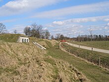
Vestvolden

Vestvolden (
Christian IX's support for Provisional Financial Laws. This included support from the so-called Landstinget as well. The Landstinget was a smaller assembly of politicians, of which half of its members were chosen by the Monarch.[3]
Its use as fortification ceased in 1920. However, it continued to be used for military purposes, and was not opened to the public until 1963.[4] Today, it is a recreational area, and has been a protected area since 1993.[4][5]
References
Notes
- ^ Asmussen 2013, pp. 8–9.
- ^ Asmussen 2013, p. 17.
- ^ Peter Ilsøe & Johs. Lomholt-Thomsen, "Norden Historie 2, 1864-1964" , Published by Gyldendalske Boghandel, Nordisk Forlag A/S, Copenhagen in 1965, (no ISBN), pages 34 and 39-40
- ^ a b "Værdifulde kulturmiljøer i København: Københavns Nyere Befæstning" (PDF) (in Danish). Copenhagen Municipality. 2014. Retrieved 2015-03-25.
- ^ "Kendelse, sag nr. 293. Fredning af Vestvolden m.v., Københavns amt" (PDF) (in Danish). Miljø- og Energiministeriet, Taksationskommissionen. 1997-06-09. Retrieved 2015-03-25.
Bibliography
- Asmussen, Jesper (2013). Vestvolden og Nordfronten – Danmarks største fæstningsanlæg (in Danish). Lindhardt og Ringhof. ISBN 978-87-11-38227-1.
External links
Wikimedia Commons has media related to Vestvolden.
- Københavns Befæstning / The Fortifications
- The Fortifications of Copenhagen 1880 to 1920
- Oplevelsescenter Vestvolden (in Danish)
- Vestvolden/The Western Ramparts at Københavnergrøn/Copenhagen Green
