
Viking 2
 Viking Orbiter | |
| Mission type | Orbiter and Lander |
|---|---|
| Operator | NASA |
| COSPAR ID | |
| SATCAT no. |
|
| Website | Viking Project Information |
| Mission duration | Orbiter: 1050 days (1022 sol)[1] Lander: 1316 days (1281 sol)[1] Launch to last contact: 1,676 days |
| Spacecraft properties | |
| Manufacturer | Orbiter: JPL Lander: Martin Marietta |
| Launch mass | 3,530 kg[a] |
| Dry mass | Orbiter: 883 kg (1,947 lb) Lander: 572 kg (1,261 lb)[2] |
| Power | Orbiter: 620 W Lander: 70 W |
| Start of mission | |
| Launch date | 18:39, September 9, 1975 (UTC) Cape Canaveral |
| End of mission | |
| Last contact | April 12, 1980[4] |
| Orbital parameters | |
| Reference system | Areocentric |
AMT)[1] | |
| Landing site | 47°38′N 225°43′W / 47.64°N 225.71°W[1] |
Flagship → | |
The Viking 2 mission was part of the American
Mission profile
The craft was launched on September 9, 1975. Following launch using a
The lander separated from the orbiter on September 3, 1976, at 22:37:50 UT and landed at Utopia Planitia. Normal operations called for the structure connecting the orbiter and lander (the bioshield) to be ejected after separation, but because of problems with the separation the bioshield was left attached to the orbiter. The orbit inclination was raised to 75 degrees on September 30, 1976.
Orbiter
The orbiter primary mission ended at the beginning of solar conjunction on October 5, 1976. The extended mission commenced on December 14, 1976, after solar conjunction. On December 20, 1976, the periapsis was lowered to 778 km and the inclination raised to 80 degrees.
Operations included close approaches to Deimos in October 1977 and the periapsis was lowered to 300 km and the period changed to 24 hours on October 23, 1977. The orbiter developed a leak in its propulsion system that vented its attitude control gas. It was placed in a 302 × 33,176 km orbit and turned off on July 25, 1978, after returning almost 16,000 images in about 700–706 orbits around Mars.
Lander

The lander and its

The Viking 2 lander touched down about 200 km west of the crater Mie in
Approximately 22 kg (49 lb) of propellants were left at landing. Due to radar misidentification of a rock or highly reflective surface, the thrusters fired an extra time 0.4 second before landing, cracking the surface and raising dust. The lander settled down with one leg on a rock, tilted at 8.2 degrees. The cameras began taking images immediately after landing.
The Viking 2 lander was powered by radioisotope generators and operated on the surface until April 12, 1980, when its batteries failed.
In July 2001, the Viking 2 lander was renamed the Gerald Soffen Memorial Station after Gerald Soffen (1926–2000), the project scientist of the Viking program.[6][7]
Results from the Viking 2 mission
Landing site soil analysis
The regolith, referred to often as "soil", resembled those produced from the weathering of basaltic
, were detected.The amount of potassium was one fifth of the average for the Earth's crust. Some chemicals in the soil contained sulfur and chlorine that were like those remaining after the evaporation of sea water. Sulfur was more concentrated in the crust on top of the soil than in the bulk soil beneath.
The sulfur may be present as
Minerals typical weathering products of
However, the way the samples were handled prohibited an exact measurement of the amount of water. But, it was around 1%.

Search for life
Viking 2 carried a biology experiment whose purpose was to look for life. The Viking 2 biology experiment weighed 15.5 kg (34 lb) and consisted of three subsystems: the
The results were unusual and conflicting: the GCMS gave a negative result; the PR gave a positive result, the GEX gave a negative result, and the LR gave a positive result.[16] Viking scientist Patricia Straat stated in 2009, "Our (LR) experiment was a definite positive response for life, but a lot of people have claimed that it was a false positive for a variety of reasons."[17]
Many scientists believe that the data were due to inorganic chemical reactions of the soil; however, this view may be changing due to a variety of discoveries and studies since Viking, including, the discovery of near-surface ice near the Viking landing zone, the possibility of perchlorate destruction of organic matter, and the reanalysis of GCMS data by scientists in 2018.[18] Some scientists still believe the results were due to living reactions. The formal declaration at the time of the mission was that the discovery of organic chemicals was inconclusive.[citation needed]
Mars has almost no ozone layer, unlike the Earth, so UV light sterilizes the surface and produces highly reactive chemicals such as peroxides that would oxidize any organic chemicals.
Viking 2 lander image gallery


-
 First color image (Viking 2 lander Camera 2 sol 2, September 5, 1976) 14:36
 -
 Viking 2 lander Camera 2 22G144 (Low Resolution Color) Sol 552 19:16
 -
 Frost on Mars.
 -
 Viking 2 lander Camera 2 FROST (Low Resolution Color) Sol 955 12:13
 -
 Frost at the landing site. (false color)
 -
 Viking 2 lander Camera 1 FROST (Low Resolution Color) Sol 960 14:14
 -
 Viking 2 lander Camera 1 FROST HIGH RESOLUTION (With Low Resolution Color) Sol 959 14:39
 -
 Viking 2 lander Camera 2 SKY AT SUNRISE (Low Resolution Color) Sol 34 04:22
 -
 Viking 2 lander Camera 2 SKY AT SUNRISE (Low Resolution Color) Sol 631 04:00


.jpg)
.jpg)
Orbiter results
Viking program
The Viking Orbiters resulted in massive discoveries about the concept water on Mars. Huge river valleys were found in many areas. They showed that floods of water carved deep valleys, eroded grooves into bedrock, and traveled thousands of kilometers. Areas of branched streams, in the southern hemisphere, suggested that rain once fell.[22][23][24]
The images below are mosaics of many small, high resolution images.
-
 Streamlined islands seen by Viking showed that large floods occurred on Mars. Image is located in Lunae Palus quadrangle.
 -
 Tear-drop shaped islands caused by flood waters fromGoldcraters.
 -
 Scour patterns, located inDromorecrater is shown on the next image.
 -
 Great amounts of water were required to carry out the erosion shown in this Viking image. Image is located inDromore.
 -
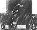
 Waters from Vedra Valles, Maumee Valles, and Maja Valles flowed from Lunae Planum on the left, to Chryse Planitia on the right. Image is located in Lunae Palus quadrangle and was taken by Viking Orbiter.
 -
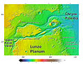 Area around northern Kasei Valles, showing relationships among Kasei Valles, Bahram Vallis, Vedra Valles, Maumee Valles, and Maja Valles. Map location is in Lunae Palus quadrangle and includes parts of Lunae Planum and Chryse Planitia.
 -
 The ejecta from Arandas crater acts like mud. It moves around small craters (indicated by arrows), instead of just falling down on them. Craters like this suggest that large amounts of frozen water were melted when the impact crater was produced. Image is located in Mare Acidalium quadrangle and was taken by Viking Orbiter.
 -
 This view of the flank ofAlba Patera shows several channels/troughs. Some channels are associated with lava flows; others are probably caused by running water. A large trough or graben turns into a line of collapse pits. Image is located in Arcadia quadrangleand was taken by Viking Orbiter.
 -
 Branched channels in Thaumasia quadrangle, as seen by Viking Orbiter. Networks of channels like this are strong evidence for rain on Mars in the past.
 -
 The branched channels seen by Viking from orbit strongly suggested that it rained on Mars in the past. Image is located in Margaritifer Sinus quadrangle.
 -
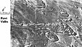 Ravi Vallis, as seen by Viking Orbiter. Ravi Vallis was probably formed when catastrophic floods came out of the ground to the right (chaotic terrain). Image located in Margaritifer Sinus quadrangle.
 -
 Deimos, photo taken in 1977.


Location

 Clickable image: Clicking on the labels will open a new article.
See also
- Exploration of Mars
- List of missions to Mars
- List of Mars orbiters
- Timeline of artificial satellites and space probes
- U.S. Space Exploration History on U.S. Stamps
Notes
References
- ^ a b c d e f g h Williams, David R. (December 18, 2006). "Viking Mission to Mars". NASA. Retrieved February 2, 2014.
- ^ National Space Science Data Center.
- ^ a b Nelson, Jon. "Viking 2". NASA. Retrieved February 2, 2014.
- ^ NASA.gov
- National Space Science Data Center. Retrieved August 16, 2019.
- ^ a b "In Depth: Viking 2". NASA Science – Solar System Exporation. NASA.
- ^ Malik, Tariq (August 22, 2012). "Mars Rover Landing Site Named for Sci-Fi Icon Ray Bradbury". Space.com.
- ^ Clark, B. et al. 1976. Inorganic Analysis of Martian Samples at the Viking Landing Sites. Science: 194. 1283–1288.
- ^ Mars Exploration Rover Mission: Press Release Images: Opportunity
- ^ Baird, A. et al. 1976. Mineralogic and Petrologic Implications of Viking Geochemical Results From Mars: Interim Report. Science: 194. 1288–1293.
- ^ Arvidson, R et al. 1989. The Martian surface as Imaged, Sampled, and Analyzed by the Viking Landers. Reviews of Geophysics:27. 39-60.
- ^ Hargraves, R. et al. 1976. Viking Magnetic Properties Investigation: Further Results. Science: 194. 1303–1309.
- ^ Arvidson, R, A. Binder, and K. Jones. The Surface of Mars. Scientific American
- ^ Bertelsen, P. et al. 2004. Magnetic Properties Experiments on the Mars Exploration rover Spirit at Gusev Crater. Science: 305. 827–829.
- ^ Life on Mars Archived October 20, 2014, at the Wayback Machine
- ^ Viking Data May Hide New Evidence For Life. Barry E. DiGregorio, July 16, 2000.
- ^ Viking 2 Likely Came Close to Finding H2O. Archived September 30, 2009, at the Wayback Machine
- S2CID 133854625.
- ^ Hartmann, W. 2003. A Traveler's Guide to Mars. Workman Publishing. NY NY.
- ^ Alien Rumors Quelled as NASA Announces Phoenix Perchlorate Discovery. Archived September 4, 2010, at the Wayback Machine A.J.S. Rayl, August 6, 2008.
- New York Times. Retrieved October 10, 2013.
- ISBN 978-0-8165-1257-7.
- ^ Raeburn, P. 1998. Uncovering the Secrets of the Red Planet Mars. National Geographic Society. Washington D.C.
- ^ Moore, P. et al. 1990. The Atlas of the Solar System. Mitchell Beazley Publishers NY, NY.