
Vikos Gorge
| Vikos Gorge | |
|---|---|
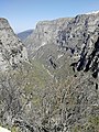
 View of Vikos Gorge from Beloi | |
 Vikos Gorge | |
| Geography | |
| Country | Greece |
| State/Province | Epirus |
| District | Ioannina |
| Population center | Zagori |
| Coordinates | 39°58′10″N 20°43′42″E / 39.96944°N 20.72833°E |
The Vikos Gorge or Vikos Canyon (
Vikos is listed as the world's "deepest relative to its width" gorge by the
Etymology
There are a number of views regarding the etymology of the name:[3]
- According to Ioannis Lambridis it derives from Slavic and means 'chasm' or 'gorge'.
- According to Evangelos Bogas it derives from the Greek βίκος 'stamnos with ears', which denotes the shape of the gorge and the echoes caused by sounds within it. The word was recorded in the lexicon of Hesychius of Alexandria.
- According to Konstantinos Amantos it derives from the Greek phytonym βικίον.
- According to Konstantinos Oikonomou it derives from an Albanian word for bridge or wooden pass, vig-u or vig-ku, due to an Ottoman-era wooden bridge that was once placed in the canyon; Kostandin Kristoforidhi associates it with the ancient Greek word βαβύκα 'bridge', recorded in the lexicon of Hesychius of Alexandria. Τhe same word is also found in the Greek dialects of northern Epirus with the form βίγκι, and in Aromanian with the forms vig or viga.
Location
The gorge is found in the core zone of the Vikos–Aoös National Park, in the Zagori region. Its main part begins between the villages of Vitsa and Koukouli and ends near the village of Vikos (or Vitsiko).[4] The gorge collects the waters of a number of small, mostly seasonal streams and leads them into the Voidomatis River which forms in the end part of the main gorge. The major part of the Vikos gorge stream is only seasonal, and is permanent only at the lowest part of the gorge.[1] Vikos is also a site of major scientific interest, because it is in almost virgin condition, it is a haven for endangered species and contains many and varied ecosystems.
Geomorphology

The Vikos Gorge, with a length of 32 km (20 mi), walls that range from 120–1,350 m (390–4,400 ft) deep, and a width ranging from 2,500 m (8,202 ft) to just a few meters at its narrowest part, is listed by the
The landscape of the 32 km long gorge, 12 km of which belongs to the park's core zone,
As the Vikos Gorge is a deep cross section of the mountain, its slopes expose a series of rock formations of various ages. The upper layers, at a depth of 0–200 m (660 ft), consist of relatively young
During the large
Wildlife
Flora
A significant number of herbs of the Vikos Gorge and adjacent areas within the Vikos-Aoos National park were regarded to have medicinal properties and were once harvested by local healers, colloquially referred to as "
Fauna
One of the special local attractions is the existence of the chamois (Rupicapra rupicapra), a rare species that lives at higher altitudes far from human activity, especially at the rocky cliffs,[18] for example in Megas Lakos, a secondary ravine of the Vikos Gorge.[19][20]
Recreation
There is a natural viewing platform over the deepest part of the gorge at Oxia, a location 8 km by a newly constructed road from the village of
A hiking trail descends into the gorge from Monodendri. The trail then leads north through the gorge to the springs of the Voidomatis river, from where paths lead out of the gorge to the village of
Human history
Important
Gallery
-
 View of Vikos Gorge from Oxia.
 -
 View of Vikos Gorge from Oxia.
 -
 View of Vikos Gorge from Vikos village.
 -
 View of Vikos Gorge from Vikos village.
 -
 Trail that leads to Vikos Gorge.
 -
 Trail that leads to Vikos Gorge.
.jpg)
_3.jpg)
_2.jpg)
_3.jpg)
.jpg)
_3.jpg)
References
- ^ a b Amanatidou, Despoina (2005). "A case study in Vikos-Aoos National Park - Greece" (PDF). University of Freiburg. Retrieved 2009-07-27.
- ^ ISBN 978-1-892051-22-6.
- hdl:10442/hedi/0252. Retrieved 13 May 2020.
- NATURA 2000. 2009. p. 8. Archived from the original(PDF) on 2011-07-16. Retrieved 2010-07-12.
- ^ Hatzopoulou Magda. "About Greece-Landscape" (PDF). General Secretariat of Information, Greece. p. 7. Archived from the original (PDF) on 2013-03-20. Retrieved 2009-08-23.
- ISBN 978-1-74104-656-4.
- ^ Amanatidou: p. 17
- ^ a b Hanlidou, Kokkini 1997, p. 2
- ^ a b Amanatidou 2005, pp. 21–22
- ^ Amanatidou p. 32
- ^ Woodward, Hamlin, Macklin, Hughes, Lewin 2008, p. 64
- ^ Woodward, Hamlin, Macklin, Hughes, Lewin 2008, p. 49
- ^ Woodward, Hamlin, Macklin, Hughes, Lewin 2008, p. 63
- ^ a b Hanlidou, Kokkini 1997, p. 1
- ^ Vokou, Katradia, Kokkini 1993, p. 1,8
- ^ Vokou, Katradia, Kokkini 1993, pp. 3–8
- ]
- ^ Natura 2000: p. 9
- ^ Amanatidou 2005, p. 29
- ^ Drakopoulou 2004, p. 26
- S2CID 129633469.
- ^ Papadopoulou 2008, p. 14
- ^ Amanatidou 2005, p. 34
External links
![]() Media related to Vikos Gorge at Wikimedia Commons
Media related to Vikos Gorge at Wikimedia Commons