
Beirut vilayet
(Redirected from
Vilayet of Beirut
)the Ottoman Empire | |||||||||||||
|---|---|---|---|---|---|---|---|---|---|---|---|---|---|
| 1888–1917 | |||||||||||||
.svg) Flag | |||||||||||||
 Map of the Ottoman Levant showing the Beirut Vilayet and its Sanjaks. | |||||||||||||
| Capital | Beirut | ||||||||||||
| Area | |||||||||||||
• 1885[1] | 30,490 km2 (11,770 sq mi) | ||||||||||||
| Population | |||||||||||||
• 1885[1] | 533,500 | ||||||||||||
| History | |||||||||||||
• Established | 1888 | ||||||||||||
• Disestablished | 1917 | ||||||||||||
| |||||||||||||
| Today part of | Lebanon Israel Palestine Syria | ||||||||||||
The Vilayet of Beirut (
Aleppo Vilayet to the north, the autonomous Mutasarrifate of Jerusalem to the south and the Mediterranean Sea
to the west.
At the beginning of the 20th century, it reportedly had an area of 11,773 square miles (30,490 km2), while the preliminary results of the first Ottoman census of 1885 (published in 1908) gave the population as 533,500.[1] It was the 4th most heavily populated region of the Ottoman Empire's 36 provinces.[4]
Administrative divisions
Sanjaks of the vilayet:[5]
Maps
-
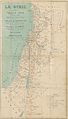 Vital Cuinet's 1896 map of the region of Syria, including the Beirut vilayet.
 -
 1893 map of administrative divisions of Ottoman Asia
 -
 A map showing the administrative divisions of the Ottoman Empire in 1317 Hijri, 1899 Gregorian, Including the Beirut Vilayet and its Sanjaks and the Syria/Damascus Vilayet and its Sanjaks.
_LA_SYRIE.jpg)
.jpg)

See also
References
- ^ A. H. Keane, page 460. Note: The accuracy of the population figures ranges from "approximate" to "merely conjectural", depending on the region from which they were gathered.
- ^ Encyclopedia of the Ottoman Empire, p. 87, at Google Books By Gábor Ágoston, Bruce Alan Masters
- ISBN 978-1-107-03363-4. Retrieved 2013-06-08.
- ISBN 978-0-299-09160-6.
Table IV.2 Population Density per km2, and Density Rank, 1894/95 (R. 1310), Rank 4, with population of 573,000 and density of 45.47 per km2; underlying source IUKTY 9075
- ^ Beyrut Vilayeti ve Cebel-i Lübnan Mutasarrıflığı | Tarih ve Medeniyet
Chisholm, Hugh, ed. (1911). . Encyclopædia Britannica (11th ed.). Cambridge University Press.
External links
 Media related to Beirut Vilayet at Wikimedia Commons
| Authority control databases: National |
|---|