
Syria vilayet
| Vilayet of Syria ولايت سوريه (in Ottoman Turkish) Vilâyet-i Sûriye ولاية سوريا (in Arabic) | |||||||||||||
|---|---|---|---|---|---|---|---|---|---|---|---|---|---|
the Ottoman Empire | |||||||||||||
| 1865–1918 | |||||||||||||
.svg) Flag | |||||||||||||
| Capital | Damascus | ||||||||||||
| Population | |||||||||||||
• 1897[1] | 701,812 | ||||||||||||
| History | |||||||||||||
• Established | 1865 | ||||||||||||
• Disestablished | 1918 | ||||||||||||
| |||||||||||||
| Today part of | Syria Jordan | ||||||||||||
The Vilayet of Syria
At the beginning of the 20th century, it reportedly had an area of 62,180 square kilometres (24,009 sq mi), while the preliminary results of the first Ottoman census of 1885 (published in 1908) gave the population as 1,000,000.[5] The accuracy of the population figures ranges from "approximate" to "merely conjectural" depending on the region from which they were gathered.[5]
History
In 1864, the
In 1872, a new administrative region was created, with its center in Ma'an, but the costs for the new administrative unit far outweighed the revenues, and it was closed the following year.[7] In 1884, the governor of Damascus made a proposal to establish a new vilayet of southern Syria, though nothing came out of this.[7]
In 1888, a
As of 1897, the Vilayet Syria was divided into four
-
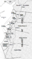 Map of Ottoman Levant showing the Beirut Vilayet and its Sanjaks and the Syria Vilayet and its Sanjaks.
 -
 1893 map of administrative divisions of Ottoman Asia
 -
 A map showing the administrative divisions of the Ottoman Empire in 1317 Hijri, 1899 Gregorian, Including the Beirut Vilayet and its Sanjaks and the Syria/Damascus Vilayet and its Sanjaks.

.jpg)

See also
References
- ^ Mutlu, Servet. "Late Ottoman population and its ethnic distribution" (PDF). pp. 29–31. Corrected population for Mortality Level=8.
- ^ Chisholm, Hugh, ed. (1911). . Encyclopædia Britannica (11th ed.). Cambridge University Press.
- ^ Salname-yi Vilâyet-i Suriye ("Yearbook of the Vilayet of Syria"), Syria vilâyet matbaası, Suriye [Syria], 1300 [1882]. in the website of Hathi Trust Digital Library.
- ISBN 8172680120
- ^ A. H. Keane, page 460
- ^ ISBN 978-1-107-03363-4
- ^ ISBN 978-0-521-89223-0. Retrieved 2013-06-10.
- ISBN 9780520200869.
- ISBN 9789004097964
External links
 Media related to Syria Vilayet at Wikimedia Commons