
Vis (island)
 | |
 | |
| Geography | |
|---|---|
| Location | Adriatic Sea |
| Coordinates | 43°02′33″N 16°09′09″E / 43.04250°N 16.15250°E |
| Area | 89.72 km2 (34.64 sq mi) |
| Highest elevation | 587 m (1926 ft) |
| Highest point | Hum |
| Administration | |
Croatia | |
| County | Split-Dalmatia |
| Largest settlement | Vis (pop. 1,920) |
| Demographics | |
| Population | 3,313 (2021) |
| Pop. density | 36.92/km2 (95.62/sq mi) |
Vis (pronounced
Geography
| Year | Pop. | ±% |
|---|---|---|
| 1857 | 6,304 | — |
| 1869 | 6,485 | +2.9% |
| 1880 | 7,871 | +21.4% |
| 1890 | 8,647 | +9.9% |
| 1900 | 9,914 | +14.7% |
| 1910 | 10,107 | +1.9% |
| 1921 | 9,788 | −3.2% |
| 1931 | 8,756 | −10.5% |
| 1948 | 7,485 | −14.5% |
| 1953 | 7,890 | +5.4% |
| 1961 | 7,004 | −11.2% |
| 1971 | 5,049 | −27.9% |
| 1981 | 4,134 | −18.1% |
| 1991 | 4,361 | +5.5% |
| 2001 | 3,637 | −16.6% |
| 2011 | 3,460 | −4.9% |
| 2021 | 3,313 | −4.2% |
| Source: Naselja i stanovništvo Republike Hrvatske 1857–2001, DZS, Zagreb, 2005 | ||
The farthest inhabited island off the Croatian mainland, Vis had a population of 3,313 in 2021. Vis has an area of 90.26 square kilometres (34.85 square miles). Its highest point is
History
Ancient history
Vis was inhabited by the time of the
In the 1st century BC, the island was held by the Liburnians.[3]
Under Venice
Until 1797, the island was under the rule of the Republic of Venice. During this time large settlements developed along the coastline (Comisa (now Komiža) and Lissa (now Vis)). Administratively, the island of Lissa was for centuries bound to the island of Lesina, now named Hvar. The Venetian influence is still recognizable in architecture found on the island, and some vocabulary of the Croatian dialect spoken locally is Venetian in origin.[citation needed]
Long 19th century
After the short-lived Napoleonic
The sea to the north of the island was the location of two battles:
- on 13 March 1811, a small Royal Navy squadron under the command of Captain William Hoste, defeated a larger French squadron in the Battle of Lissa (1811)
- on 20 July 1866, the smaller Austrian fleet, under Admiral Wilhelm von Tegetthoff, attacked the Italian fleet, under Admiral Carlo Pellion di Persano, defeating the larger Italian force and sinking the Re d'Italia in the Battle of Lissa (1866).
Second World War
Vis was at one point the site of the general headquarters of Marshal Josip Broz Tito, the leader of the Yugoslav Partisan resistance movement. It was occupied by Italy between 1941 and 1943, then was liberated by the Partisans and held by a British flotilla in 1943–44. At the end of World War II the island returned to Yugoslavia. During the war the island was mined. Allied fighter planes were based at a small airfield that was also used for emergency landings of Allied bombers, including an American B-24 flown by George McGovern. No. 6 Squadron RAF extensively used the airfield as a forward operating base, flying Hawker Hurricane Mk IV fighter aircraft, from May 1944 to February 1945.[7][8]
During World War II, a crate of the Armed Services Editions of paperback books was dropped by parachute along with other supplies on to Vis Island off the coast of Yugoslavia. The books were then read aloud to the partisans by English speaking soldiers who translated the books as they read them.[9]
Early in July 1944, the novelist
During WWII the island was also home to 1435 Squadron of the RAF flying Mark IX Spitfires in ground support of allied troops fighting in Italy.
After 1945
After the war, the Yugoslav People's Army used the island as one of its main naval bases until abandoning the base in 1989.[14] After Croatia became independent in 1991, its navy did not reclaim most of the facilities, and the many abandoned buildings are being used for civilian purposes and tourism, including tunnels, bunkers and a secret submarine base.[14] In 2008, 34 mines left over from World War II were cleared from the island.[citation needed]
In 2017 the movie Mamma Mia! Here We Go Again was filmed on location on Vis.[15]
In 2019 GEOPARK Vis archipelago became a member of UNESCO Global Geoparks.[16]
Administration
Vis town and Komiža are seats of separate administrative municipalities which cover the entire island and nearby islets, which are both part of Split-Dalmatia County.
Economy
The island's main industries are agriculture (mainly viticulture), fishing, fish processing, and tourism.[17]
Around 20% of the island's arable land is covered with vineyards. Autochthonous vine species cultivated on the island are Plavac Mali, Kurteloška, and Vugava.[18] Vugava is autochthonous variety of wine of island Vis.[19]
The sea around Vis is rich with fish, especially blue fish (sardine, mackerel and anchovy). Komiža fishermen of the 16th century developed their own type of fishing boat, the falkuša, which was used until the second half of the 20th century because of its excellent features.[18]
Access
Vis is accessed only by boat from Split. Jadrolinija services the island using mainly the car ferry Petar Hektorović, with the scheduled voyage time of 2h20'. There is also a high-speed passenger catamaran service Split-Milna-Hvar-Vis provided by Jadrolinija which takes 1h30'. During the summer season (from 31.05. - 29.09.), the ferry and high-speed catamaran prices are higher.[20]
There used to be direct ship lines to Italy during summer season. In 2010 Termoli Jet started Termoli-Vis-Split line, taking 3h30' to reach Vis from Italian city of Termoli.[21] In 2015, Blue Line ran the now cancelled night ferry service Ancona-Vis.[22]
In 2016, now-defunct European Coastal Airlines tried establishing seaplane passenger service Split-Vis, which took some 15 minutes.[23]
Gallery
-
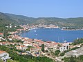 Town and bay of Vis
 -
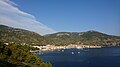 Komiža town
 -
 Stiniva Bay
 -
 Map of Vis
 -
 Tito's cave
 -
 Partisan planes on Vis airfield, World War 2
 -
 Submarine bunker, military installation left from Yugoslav army times


Notable people
References
- ^ An Inventory of Archaic and Classical Poleis: An Investigation Conducted by The Copenhagen Polis Centre for the Danish National Research Foundation by Mogens Herman Hansen, 2005, Index
- ^ The Princeton Encyclopedia of Classical Sites (eds. Richard Stillwell, William L. MacDonald, Marian Holland McAllister), ISSA (Vis) Croatia.
- ISBN 0-631-19807-5, p. 183, "... We may begin with the Venetic peoples, Veneti, Carni, Histri and Liburni, whose language set them apart from the rest of the Illyrians. ..."
- ^ Bartoli, Matteo. Le parlate italiane della Venezia Giulia e della Dalmazia. Tipografia italo-orientale. Grottaferrata 1919
- ^ Colella, Amedeo. L'esodo dalle terre adriatiche. Rilevazioni statistiche. Edizioni Opera per Profughi. Roma, 1958
- ^ Spezialortsrepertorium Von Dalmatien, bearbeitet aufgrund der Ergebnisse der Volkszählung am 20. Dezember 1910. Wien: Verl. d. Deutschösterr. Staatsdruckerei, 1919. Print., s. 21: Lissa
- ISBN 1-84037-141-2.
- ^ The "Tin-opener". No 6 Squadron (RAF ) Association Newsletter. July 2014.
- ^ Council on Books in Wartime, and Robert O. Ballou. A History of the Council on Books in Wartime, 1942–1946. 1946. p. 81.
- ^ a b Churchill 1997, p. 251
- ^ Lovell 2012, p471-6
- ^ Soames 2003, p389-90
- ^ Churchill 1997, p. 252, 256
- ^ a b Ryan (15 March 2015). "Take a Look Inside These Abandoned Submarines & Bases". History in Orbit website. pp. 34–37. Archived from the original on 11 January 2019. Retrieved 6 July 2018.
- ^ Demark, Nikolina (15 August 2017). "Will the Filming of 'Mamma Mia' Affect the Island of Vis?". Total Croatia News. Archived from the original on 15 August 2017. Retrieved 16 August 2017.
- ^ "Vis Archipelago Enters UNESCO Global Geopark Network".
- ^ (in Croatian) First Croatian online peljar
- ^ a b Economy of Vis Archived 7 June 2007 at the Wayback Machine
- ^ "Indigenous Treasures of island Vis". Slobodna Dalmacija. Retrieved 19 March 2024.
- ^ "Split-Vis price list for 2024". Jadrolinija. Retrieved 19 March 2024.
- ^ Redazione (10 May 2010). "Termoli-Croazia: Il catamarano pronto alla partenza. Primo viaggio il 24 giugno". myNews Termoli e Molise (in Italian). Retrieved 10 July 2023.
- ISBN 978-88-911-9181-6.
- ^ News, Total Croatia (9 September 2016). "European Coastal Airlines Seaplane Docks at Island of Vis". Total Croatia. Retrieved 10 July 2023.
{{cite web}}:|last=has generic name (help)
- Jefford, C.G. RAF Squadrons, a Comprehensive Record of the Movement and Equipment of all RAF Squadrons and their Antecedents since 1912. Shrewsbury: Airlife Publishing, 2001. ISBN 1-84037-141-2.
- The "Tin-opener". No 6 Squadron (RAF ) Association Newsletter. July 2014.
Books
- Churchill, Winston (1997). His Father's Son: The Life of Randolph Churchill. London: Orion. ISBN 978-1-85799-969-3.
- Lovell, Mary S. (5 April 2012). The Churchills: A Family at the Heart of History – from the Duke of Marlborough to Winston Churchill. Abacus. ISBN 978-0-349-11978-6.
- Soames, Mary (2003). Clementine Churchill. London: Doubleday. ISBN 978-0-385-60741-4.
External links
- Komiza - Island Vis Tourist Association
- Vis - Croatian National Tourist Board
- Vis Tourist Association
| ||
| International | |
|---|---|
| National | |
| Geographic | |