
Vredefort impact structure
| Vredefort impact structure | |
|---|---|
| Vredefort Dome | |
Vaal river running across it; seen from space with the Operational Land Imager on Landsat 8, 27 June 2018 | |
| Impact crater/structure | |
| Confidence | Confirmed |
| Diameter | 170–300 km (110–190 mi) (estimated former crater diameter) |
| Age | ± 4 Ma Orosirian, Paleoproterozoic |
| Exposed | Yes |
| Drilled | Yes |
| Location | |
| Coordinates | 27°0′0″S 27°30′0″E / 27.00000°S 27.50000°E |
| Country | South Africa |
| Province | Free State |
 Location of Vredefort impact structure | |
| Official name | Vredefort Dome |
| Includes |
|
| Criteria | Natural: (viii) |
| Reference | 1162 |
| Inscription | 2005 (29th Session) |
| Area | 30,000 ha (120 sq mi) |
The Vredefort impact structure is the
In 2005, the Vredefort Dome was added to the list of UNESCO World Heritage Sites for its geologic interest.
Formation and structure


The asteroid that hit Vredefort is estimated to have been one of the largest ever to strike Earth since the Hadean Eon some four billion years ago, originally thought to have been approximately 10–15 km (6.2–9.3 mi) in diameter.[4] As of 2022, the bolide was estimated at between 20 and 25 kilometres (12 and 16 mi) in diameter and to have impacted with a vertical velocity of 15–25 kilometres per second (34,000–56,000 mph).[3]
The original impact structure is estimated to have had a diameter of at least 170 km (110 mi), with the impact affecting the structure of the surrounding host rock in a circular region around 300 km (190 mi) in diameter.
Estimates have placed the structure’s age to be 2.023 billion years (± 4 million years)
The dome in the centre of the impact structure was originally thought to have been formed by a volcanic explosion, but in the mid-1990s, evidence revealed it was the site of a huge bolide impact, as telltale shatter cones were discovered in the bed of the nearby Vaal River.
This impact structure is one of the few multiple-ringed impact structures on Earth, although they are more common elsewhere in the Solar System. Perhaps the best-known example is Valhalla crater on Jupiter's moon Callisto. Earth's Moon has some as well. Geological processes, such as erosion and plate tectonics, have destroyed most multiple-ring impact structures on Earth.
The impact distorted the
From about halfway through the Pretoria Subgroup of rocks around the impact structure's centre, the order of the rocks is reversed. Moving outwards towards where the crater rim used to be, the Ghaap Dolomite group resurfaces at 60 km (37 mi) from the centre, followed by an arc of Ventersdorp lavas, beyond which, at between 80 and 120 km (50 and 75 mi) from the centre, the Witwatersrand rocks re-emerge to form an interrupted arc of outcrops today. The Johannesburg group is the most famous one because it was here that gold was discovered in 1886.[4][14] It is thus possible that if it had not been for the Vredefort impact this gold would never have been discovered.[4]
The 40-kilometre-diameter (25 mi) centre of the Vredefort impact structure consists of a granite dome (where it is not covered by much younger rocks belonging to the
-
 A timeline of the Earth's history indicating when the Vredefort impact structure was formed in relation to some of the other importantoxygen-free atmosphere. The Earth's crust was wholly or partially molten during the Hadean Eon. One of the first microcontinents to form was the Kaapvaal Craton, which is exposed at the centre of the Vredefort Dome, and again north of Johannesburg.
 -
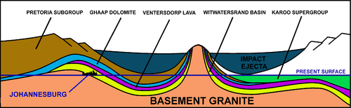 A schematic diagram of a NE (left) to SW (right) cross-section through the 2.020-billion-year-old Vredefort impact structure and how it distorted the contemporary geological structures. The present erosion level is shown. Johannesburg is where the Witwatersrand Basin (the yellow layer) is exposed at the "present surface" line, just inside the impact structure's rim, on the left. Not to scale.


Conservation
The Vredefort Dome World Heritage Site is currently subject to property development, and local owners have expressed concern regarding sewage dumping into the Vaal River and the impact structure.[15] The granting of prospecting rights around the edges of the impact structure has led environmental interests to express fear of destructive mining.
Community
The Vredefort Dome in the centre of the impact structure is home to four towns: Parys, Vredefort, Koppies and Venterskroon. Parys is the largest and a tourist hub; both Vredefort and Koppies mainly depend on an agricultural economy.
On 19 December 2011, a broadcasting licence was granted by ICASA to a community radio station to broadcast for the Afrikaans- and English-speaking members of the communities within the impact structure. The Afrikaans name Koepel Stereo (Dome Stereo) refers to the dome and announces its broadcast as KSFM. The station broadcasts on 94.9 MHz FM.
See also
- List of impact structures on Earth
- List of possible impact structures on Earth
- Deniliquin multiple-ring feature
References
- ^ University of Rochester (26 September 2022). "The asteroid that formed Vredefort crater was bigger than previously believed". Science X. Archived from the original on 26 September 2022.
- ^ ISSN 2169-9097.
- ^ S2CID 251449730.
- ^ OCLC 883592852.
- .
- ISSN 0091-7613.
- ^
- . Retrieved 12 October 2023.
- OCLC 974035410.
- OCLC 488347575.
- ^ a b Geological map of South Africa, Lesotho and Swaziland (1970). Council for Geoscience, Geological Survey of South Africa.
- ^ Momberg, Eleanor (23 August 2009). "River heading for the rocks". Retrieved 22 March 2011.
External links
- Parys South Africa
- Impact Cratering Research Group – University of the Witwatersrand
- Earth Impact Database
- Deep Impact – The Vredefort Dome
- Satellite image of Vredefort impact structure from Google Maps
- Impact Cratering: an overview of Mineralogical and Geochemical aspects – University of Vienna Archived 2011-07-06 at the Wayback Machine
- Google Earth 3d .KMZ of 25 largest craters (requires Google Earth)
For official site names, see each article or the List of World Heritage Sites in South Africa. | ||
| ||
| Lists |
|   |
|---|---|---|
| Confirmed≥20 km diameter |
| |
| Topics |
| |
| Research | ||