
Walsall Canal

The Walsall Canal is a narrow (7 feet or 2.1 metres) canal, seven miles (11 km) long, forming part of the Birmingham Canal Navigations, and passing around the western side of Walsall, West Midlands, England.
Route
Walsall Canal | ||||||||||||||||||||||||||||||||||||||||||||||||||||||||||||||||||||||||||||||||||||||||||||||||||||||||||||||||||||||||||||||||||||||||||||||||||||||||||||||||||||||||||||||||||||||
|---|---|---|---|---|---|---|---|---|---|---|---|---|---|---|---|---|---|---|---|---|---|---|---|---|---|---|---|---|---|---|---|---|---|---|---|---|---|---|---|---|---|---|---|---|---|---|---|---|---|---|---|---|---|---|---|---|---|---|---|---|---|---|---|---|---|---|---|---|---|---|---|---|---|---|---|---|---|---|---|---|---|---|---|---|---|---|---|---|---|---|---|---|---|---|---|---|---|---|---|---|---|---|---|---|---|---|---|---|---|---|---|---|---|---|---|---|---|---|---|---|---|---|---|---|---|---|---|---|---|---|---|---|---|---|---|---|---|---|---|---|---|---|---|---|---|---|---|---|---|---|---|---|---|---|---|---|---|---|---|---|---|---|---|---|---|---|---|---|---|---|---|---|---|---|---|---|---|---|---|---|---|---|
| ||||||||||||||||||||||||||||||||||||||||||||||||||||||||||||||||||||||||||||||||||||||||||||||||||||||||||||||||||||||||||||||||||||||||||||||||||||||||||||||||||||||||||||||||||||||
The canal runs from Ryders Green Junction where it meets the
The canal starts at the
History
The canal was built in four distinct stages. It started life as the Broadwaters Extension to the Wednesbury Canal which opened in 1785 to serve collieries in Moxley. This section was authorised as a detached part of the Birmingham & Fazeley Canal under that canal's original Act.[1]
Meanwhile from the other direction, the Birchills Branch of the Wyrley and Essington Canal reached Bloxwich Wharf to the north-west of Walsall by 1798.[2] (Much of this branch from Sneyd Junction was later subsumed into the new mainline of the Wyrley and Essington, when that canal was extended towards Huddlesford, leaving about 700 metres (2,300 ft) of the Birchills Branch as a stub.)
What was by then known as the Birmingham, Birmingham and Fazeley Canal Company was authorised by the combined company's sixth
The canal was mapped by John Snape (1737–1816) in 1808 and this was to be his last known map.[6]
The small gap between the Birmingham Canal Navigations line to Walsall and the Wyrley and Essington Canal's Birchills Branch was of concern to businessmen to the north of Walsall, whose access to the south was by a very circuitous route. An independent canal to link the two was planned, but in 1839 the BCN agreed to build a connection.[7] The Walsall Junction Canal was completed in March 1841,[8] its 0.6 miles (0.97 km) containing eight locks and completing the through route.
Points of interest
| Point | Coordinates (Links to map resources) |
OS Grid Ref | Notes |
|---|---|---|---|
| Ryders Green Junction | 52°31′22″N 2°01′20″W / 52.5228°N 2.0221°W | SO985916 | Wednesbury Old Canal |
| Toll End Junction | 52°32′14″N 2°02′08″W / 52.5372°N 2.0356°W | SO976932 | Toll End Communication Canal
|
| Ocker Hill Tunnel Branch | 52°32′22″N 2°02′09″W / 52.5394°N 2.0357°W | SO976934 | |
| Tame Valley Junction (Doe Bank Junction) | 52°32′24″N 2°02′07″W / 52.5400°N 2.0354°W | SO976935 | Tame Valley Canal |
| Gospel Oak Branch Junction | 52°32′57″N 2°02′13″W / 52.5493°N 2.0370°W | SO975945 | |
| Moorcroft Junction | 52°33′15″N 2°02′28″W / 52.5541°N 2.0411°W | SO972951 | Bradley Branch |
| Anson Branch Junction | 52°34′39″N 2°01′20″W / 52.5775°N 2.0221°W | SO986977 | Anson Branch, leading to Bentley Canal |
| Walsall Junction | 52°35′05″N 1°59′34″W / 52.5848°N 1.9928°W | SP005986 | Short branch to Walsall centre |
| Birchills Junction | 52°35′55″N 1°59′52″W / 52.5987°N 1.9979°W | SK002000 | Wyrley and Essington Canal |
Gallery
From north to south:
-
 Birchills Junction
 -
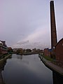
 Walsall Locks toll office and Boaters Mission
 -
 Circular weir at Walsall Lock No 5
 -
 Walsall Junction - the Town Branch
 -
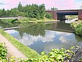
 Walsall Canal by Spine Road
 -
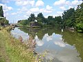
 Gospel Oak Junction (Walsall canal runs left and right)
 -
 Tame Valley Junction - start of the Tame Valley Canal
 -
 Ocker Hill Tunnel Branch Junction (now private)
 -
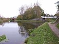
 Ryders Green Junction - southern terminus


See also
References
- ISBN 0-7524-3262-1. p33
- ISBN 1-85075-277-X. p217
- ^ Joseph Priestley, (1831), Historical Account of the Navigable Rivers, Canals, and Railways, of Great Britain
- ISBN 0-7524-3262-1. p44
- ISBN 0-7524-3262-1. p45
- ISBN 0-7277-2939-X.
- ISBN 0-7524-3262-1. p98
- ISBN 0-7509-2077-7. p73
- Pearson, Michael (1989). Canal Companion - Birmingham Canal Navigations. J. M. Pearson & Associates. ISBN 0-907864-49-X.