
Waw an Namus
| Waw an Namus | |
|---|---|
| Wau-en-Namus, Uau en Namus, Waw an Namous | |
 The central cone of Waw an Namus | |
| Highest point | |
| Elevation | 547 m (1,795 ft) |
| Coordinates | 24°55′03″N 17°45′46″E / 24.91750°N 17.76278°E[1] |
| Naming | |
| English translation | Oasis of mosquitoes |
| Geography | |
 Waw an Namus | |
| Geology | |
| Age of rock | Pleistocene[1] |
| Mountain type | Volcano |
Waw an Namus (also spelled Wau-en-Namus,
Waw an Namus is characterized by a
Name
The volcano is also known as Uaw en Namus,[2] Uau en Namus, Wau-en-Namus[3] and Wau Sqair.[4] It means "Oasis of mosquitoes", a reference to the small lakes around it[1] and the numerous mosquitoes that exist at Waw an Namus,[4] nurtured by the lakes at the volcano.[5]
Geography and geomorphology
The volcano lies within the
Waw an Namus is a 100-metre-deep (330 ft), 4-kilometre-wide (2.5 mi) caldera, which has a small relief outwards[2] but a steep margin inwards.[8] During its formation, over 800,000,000 cubic metres (2.8×10¹⁰ cu ft) of rock were displaced.[15] Another crater lies 5 kilometres (3.1 mi) northwest from Waw an Namus.[16] That vent was formed by overlapping craters which feature no volcanic rocks and which have produced salty mud; this may have been a site of phreatic activity and of volcanic degassing.[11] The caldera contains ash deposits and some dunes, but also a humid zone with reeds.[17]
Within the caldera lies a 140-metre-high (460 ft),
Dark-coloured
Lakes
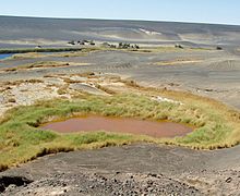
Also within the caldera are three small lakes[1] and additional smaller water bodies,[25] which together form a semicircle around the northern, eastern and southern flanks of the central cone. One of the lakes is north of the scoria cone, the second southeast and south and the third southwest.[19] These lakes cover a total surface of 0.3 square kilometres (0.12 sq mi)[25] and the largest lake has a surface area of 0.146 square kilometres (0.056 sq mi) with a depth of 12.5 metres (41 ft),[26] while the deepest of these waterbodies reaches depths of 15–16 metres (49–52 ft).[27] The water surface reaches 434 metres (1,424 ft) elevation above sea level, although seasonal variations[25] sometimes cause the lakebodies to dry up.[7] These lakes, some of which have red colours, give Waw an Namus a multicoloured appearance.[28]
The lakes are probably
Geology
Waw an Namus is an isolated volcano.
The terrain surrounding Waw an Namus is covered by
-
 The central cone
 -
 The central crater
 -
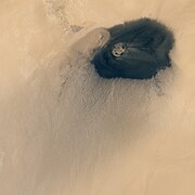 Waw an Namus seen from space; one notes the colour contrast and the lateral crater


Climate
Waw an Namus is part of the Sahara desert, one of the world's largest and driest deserts although parts of it were wetter in the past. In some parts of the Sahara it has only rained a few times during a whole century;[14] at Waw an Namus the little precipitation mostly occurs during winter.[39] Wind is the most important weather factor, forming ventifacts and dunes among other structures;[14] at Waw an Namus it mostly blows from the northeast[39] and is sometimes accompanied by dust devils south of the volcano.[40]
Eruptive history
The central scoria cone may be only a few thousand years old,
Biology
Animal life includes
-
 A lake at Waw an Namus
 -
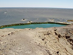 A green lake seen from the central cone
 -
 Vegetation surrounding one of the lakes at Waw an Namus
 -
 The caldera


See also
Notes
- Amphora coffeaeformis, Amphora duplex, Amphora ocellata, Amphora subtilissima, Amphora veneta, Anomoeoneis sphaerophora, Bacillaria paradoxa, Cocconeis placentula, Cymbella pusilla, Denticula sp., Mastogloia aquilegiae, Melosira goetzeana, Navicula interruptestriata, Nitschia amphibia, Nitzschia hybrida, Nitzschia sigma, Nitzscia iugiformis, Nitzscia richterae, Nitzscia sigma, Rhopalodia gibberula, Rhopalodia musculus, Stephanodiscus astraea and Synedra tabulata.[53][54]
References
- ^ a b c d e f g h i j k l "Waw an Namous". Global Volcanism Program. Smithsonian Institution.
- ^ a b c d e f g h i Bardintzeff et al. 2012, p. 1049.
- ^ "Waw an Namous". Global Volcanism Program. Smithsonian Institution., Synonyms & Subfeatures
- ^ a b Lautensach & Fischer 1957, p. 303.
- ^ Foroutan et al. 2019, p. 844.
- ^ Richter 1951, p. 16.
- ^ IUCN. p. 38.
- ^ a b c Knctsch 1950, p. 49.
- S2CID 161077245.
- ISSN 2191-5784.
- ^ a b c Knctsch 1950, p. 50.
- ^ Klitzsch 1968, p. 587.
- ISSN 2414-6064.
- ^ a b c Foroutan et al. 2019, p. 841.
- ^ a b c d e Richter 1951, p. 20.
- ^ a b c Klitzsch 1968, p. 598.
- ^ Foroutan et al. 2019, p. 843.
- ^ a b c d e Miller et al. 2012, p. 11.
- ^ a b c Pachur & Altmann 2006, p. 128.
- ^ Lautensach & Fischer 1957, p. 307.
- ISSN 0016-7185.
- ^ a b Klitzsch 1968, p. 597.
- ^ a b Pachur & Altmann 2006, p. 129.
- ^ Foroutan et al. 2019, p. 850.
- ^ a b c d e Schwabe & Simonsen 1961, p. 255.
- ^ a b c Schwabe & Simonsen 1961, p. 256.
- ^ Kanter 1967, p. 20.
- ^ Lautensach & Fischer 1957, p. 308.
- JSTOR 40173401.
- ^ a b Pachur & Altmann 2006, p. 130.
- ^ Miller et al. 2012, p. 19.
- ^ Bardintzeff et al. 2012, p. 1060.
- ^ Miller et al. 2012, p. 23.
- ^ Ball et al. 2019, p. 3547.
- ^ Ball et al. 2019, p. 3543.
- ^ Ball et al. 2019, p. 3533.
- ^ Bardintzeff et al. 2012, p. 1052.
- ^ a b Miller et al. 2012, p. 13.
- ^ a b Foroutan et al. 2019, p. 842.
- ^ Foroutan et al. 2019, p. 845.
- ^ Bardintzeff et al. 2012, p. 1054.
- ^ a b Kanter 1967, p. 12.
- ^ Scholz & Gabriel 1973, p. 176.
- ^ Scholz & Gabriel 1973, p. 180.
- ^ Kanter 1967, p. 19.
- ^ Knctsch 1950, pp. 49–50.
- ^ Hering 2009, p. 20.
- ^ Hering 2009, p. 8.
- ^ Hering 2009, pp. 9–18.
- ^ Hering 2009, p. 9.
- ^ Schwabe & Simonsen 1961, p. 257.
- ^ Schwabe & Simonsen 1961, p. 259.
- ^ Schwabe & Simonsen 1961, pp. 263–268.
- ^ Schwabe & Simonsen 1961, p. 264.
Sources
- Ball, P. W.; White, N. J.; Masoud, A.; Nixon, S.; Hoggard, M. J.; Maclennan, J.; Stuart, F. M.; Oppenheimer, C.; Kröpelin, S. (July 2019). "Quantifying Asthenospheric and Lithospheric Controls on Mafic Magmatism Across North Africa". Geochemistry, Geophysics, Geosystems. 20 (7): 3520–3555. .
- Bardintzeff, Jacques-Marie; Deniel, Catherine; Guillou, Hervé; Platevoet, Bernard; Télouk, Philippe; Oun, Khaled M. (1 June 2012). "Miocene to recent alkaline volcanism between Al Haruj and Waw an Namous (southern Libya)". S2CID 129440907.
- Foroutan, M.; Steinmetz, G.; Zimbelman, J.R.; Duguay, C.R. (February 2019). "Megaripples at Wau-an-Namus, Libya: A new analog for similar features on Mars". Icarus. 319: 840–851. S2CID 125750298.
- Hering, Jens (2009). "Beitrag zur Wintervogelwelt Libyens" (PDF). Vogelwarte (in German). 47: 5–22. Retrieved 10 April 2018.
- Kanter, Helmuth (1967). "Das Land: Die geographischen Grundlagen". Libyen / Libya. Medizinische Länderkunde / Geomedical Monograph Series (in German). Vol. 1. Springer, Berlin, Heidelberg. pp. 1–29. ISBN 9783642490767.
- Klitzsch, Eberhard (1 February 1968). "Der Basaltvulkanismus des Djebel Haroudj Ostfezzan/Libyen". Geologische Rundschau (in German). 57 (2): 585–601. S2CID 128400664.
- Knctsch, Georg (1 March 1950). "Beobachtungen in der libyschen Sahara". Geologische Rundschau (in German). 38 (1): 40–59. S2CID 129511667.
- Lautensach, Hermann; Fischer, Hans Richard. (1957). Kartographische Studien; Haack-Festschrift. Ergänzungsheft Nr. 264 zu Petermanns geographischen Mitteilungen (in German). Gothe: H. Haack.
- Miller, C.; Zanetti, A.; Thöni, M.; Konzett, J.; Klötzli, U. (January 2012). "Mafic and silica-rich glasses in mantle xenoliths from Waw an Namus, Libya: Textural and geochemical evidence for peridotite–melt reactions". ISSN 0024-4937.
- Pachur, Hans-Joachim; Altmann, Norbert (2006). Die Ostsahara im Spätquartär (in German). Springer. ISBN 978-3-540-20445-9.
- Richter, N. (1 July 1951). "Mondkraterformationen auf der Erde". Geofisica Pura e Applicata (in German). 20 (1): 15–23. S2CID 129250257.
- Scholz, H.; Gabriel, B. (1973). "Neue Florenliste aus der libyschen Sahara (A New List of Plants to the Flora of the Libyan Sahara)". JSTOR 3995521.
- Schwabe, G. H.; Simonsen, R. (1961). "Cyanophyceen und Diatomeen aus der Krateroase Wau en-Namus (Fezzan, zentrale Sahara)". .
External links
- Uau-en-Namus: Un curioso vulcano spento in Libia
- Willeitner, Joachim (2001). Libyen: Tripolitanien, Syrtebogen, Fezzan und die Kyrenaika (in German). DuMont Reiseverlag. ISBN 9783770148769.
- Rolf Cosar Vulkanfaszination: Photos Febr. 2011
![]() Media related to Waw an Namus at Wikimedia Commons
Media related to Waw an Namus at Wikimedia Commons
| |