
West London line
| West London line | ||||||||||||||||||||||||||||||||||||||||||||||||||||||||||||||||||||||||||||||||||||||||||||||||||||||||||||||||||||||||||||||||||||||||||||||||||||||||||||||||||||||||||||||||||||||||||||||||||||||||||||||||||||||||||||||||||||||||||||||||||||||||||||||||||||||||||||||||||||||||||||||||||||||||||||||||
|---|---|---|---|---|---|---|---|---|---|---|---|---|---|---|---|---|---|---|---|---|---|---|---|---|---|---|---|---|---|---|---|---|---|---|---|---|---|---|---|---|---|---|---|---|---|---|---|---|---|---|---|---|---|---|---|---|---|---|---|---|---|---|---|---|---|---|---|---|---|---|---|---|---|---|---|---|---|---|---|---|---|---|---|---|---|---|---|---|---|---|---|---|---|---|---|---|---|---|---|---|---|---|---|---|---|---|---|---|---|---|---|---|---|---|---|---|---|---|---|---|---|---|---|---|---|---|---|---|---|---|---|---|---|---|---|---|---|---|---|---|---|---|---|---|---|---|---|---|---|---|---|---|---|---|---|---|---|---|---|---|---|---|---|---|---|---|---|---|---|---|---|---|---|---|---|---|---|---|---|---|---|---|---|---|---|---|---|---|---|---|---|---|---|---|---|---|---|---|---|---|---|---|---|---|---|---|---|---|---|---|---|---|---|---|---|---|---|---|---|---|---|---|---|---|---|---|---|---|---|---|---|---|---|---|---|---|---|---|---|---|---|---|---|---|---|---|---|---|---|---|---|---|---|---|---|---|---|---|---|---|---|---|---|---|---|---|---|---|---|---|---|---|---|---|---|---|---|---|---|---|---|---|---|---|---|---|---|---|---|---|---|---|---|---|---|---|---|---|---|---|---|---|---|---|
standard gauge | ||||||||||||||||||||||||||||||||||||||||||||||||||||||||||||||||||||||||||||||||||||||||||||||||||||||||||||||||||||||||||||||||||||||||||||||||||||||||||||||||||||||||||||||||||||||||||||||||||||||||||||||||||||||||||||||||||||||||||||||||||||||||||||||||||||||||||||||||||||||||||||||||||||||||||||||||
| Electrification | Third rail, 750 V DC Overhead line, 25 kV 50 Hz AC | |||||||||||||||||||||||||||||||||||||||||||||||||||||||||||||||||||||||||||||||||||||||||||||||||||||||||||||||||||||||||||||||||||||||||||||||||||||||||||||||||||||||||||||||||||||||||||||||||||||||||||||||||||||||||||||||||||||||||||||||||||||||||||||||||||||||||||||||||||||||||||||||||||||||||||||||
| ||||||||||||||||||||||||||||||||||||||||||||||||||||||||||||||||||||||||||||||||||||||||||||||||||||||||||||||||||||||||||||||||||||||||||||||||||||||||||||||||||||||||||||||||||||||||||||||||||||||||||||||||||||||||||||||||||||||||||||||||||||||||||||||||||||||||||||||||||||||||||||||||||||||||||||||||

The West London line (WLL) is a short railway in inner West London that links
History
Origins
The Birmingham, Bristol & Thames Junction Railway was authorised in 1836 to run from the
An Act of 1845 authorised the GWR and the L&BR (which became part of the London and North Western Railway [LNWR] in 1846) to take a joint lease of the WLR. The line was used only to carry coal, and passenger service was not re-introduced. The lack of success of the line became such a regular target of Punch magazine that the line was called Punch's Railway.[2][3]
An Act in 1859 granted those two companies, with the
Operations to 1940
For a time, the West London line formed part of the GWR's Middle Circle route (1872–1905) which ran (clockwise) from Mansion House to Aldgate (originally Moorgate) via Earl's Court, Kensington Olympia, Latimer Road and Baker Street. The West London line was also part of London Underground for a time and operated as a branch of the Metropolitan Railway between Edgware Road and Addison Road. The branch was eventually closed and the link between the West London line and today's Hammersmith & City line was dismantled in 1930.
A branch was installed to allow trains from the former
The northern section of the line, from Willesden Junction to Kensington Olympia and on to Earls Court, was electrified by the LNWR in 1915.
Decline after World War II
After a period of popularity, passenger usage dwindled on the West London Railway. Competition from the new deep-level
In 1948, the line became part of British Rail, following the nationalisation of the railways, but remained mostly in use as a freight route. For many years, limited passenger trains ran on workday mornings and evenings, to carry workers at the Post Office Savings Bank headquarters, Blythe House, near Olympia from Clapham Junction and back again, but these services were not publicly advertised.
Kensington Olympia was used as late as the 1970s as a location for collecting milk tanks (for the west country) from various terminals in the London area such as Ilford. This activity later transferred to Clapham Junction.[9]

Reinstatement of passenger services
Since the 1940s the line has often been used for excursion and other special through trains across London to the South Coast. Between April 1963 and June 1965 the section between Willesden Jn and Kensington Olympia was used for trains diverted from Euston during the rebuilding of Euston station[10] section. Kensington Olympia station was refurbished accordingly. During 1967 passenger services were diverted from Paddington between Old Oak Common and Kensington Olympia during engineering works at Paddington station.
In the late 1970s, the
The line was crucial to the planned Regional Eurostar service, and between 1995 and 1997 carried two daily services connecting the ECML and WCML respectively to Waterloo for international passengers. However the idea was cancelled.[12]
Platforms were reinstated at West Brompton in 1999. In 2007, Transport for London took over the North London Railway franchise as the London Overground concession, introducing new rolling stock and rebranding the West London line trains and stations in orange livery. The line appears today on the Tube Map as an orange stripe. New stations opened at Shepherd's Bush in 2008 and Imperial Wharf in 2009, bringing main line rail services to a large catchment area in West London.
Renaming
In July 2023, TFL announced that it would be giving each of the six Overground services unique names by the end of the following year.[13][14] In February 2024, it was confirmed that the North London / West London section would be named the Mildmay line (to honour the Mildmay Hospital which treated victims of the HIV/AIDS crisis in the 1980s) and would be coloured blue on the updated network map.[15]


Regional and InterCity services
In 1966 British Rail launched Motorail, a long-distance accompanied car train which transported passengers and their cars to the West of England and Scotland. The London Motorail terminal was at Kensington (Olympia), using the West London line for its wide connections to the UK mainline rail network. Motorail ceased operations in 1981.[16]
Intercity prior to 1997, and then from 1997 to 2007
In 2009, Southern introduced its cross-London service from Milton Keynes to East Croydon.[19] For a brief period, Southern and Connex also operated a direct service from Rugby to Brighton via Gatwick Airport, but this was withdrawn in 2001.[20]
Train services

London Overground
The core operation of the West London line is the metro/commuter rail operated by London Overground. Four trains per hour run between Clapham Junction and Willesden Junction, with most trains continuing on the North London line to and from Stratford. It forms the western section of the Overground's orbital rail route which was completed in December 2012 when the East London line was extended to Clapham Junction via the South London line, linking it to the West London line.
Cross-London services
Along with the
This regional service previously ran from
-
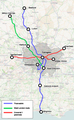 Map of cross-London rail routes present and planned
 -
 The orbital lines of the London Overground network (as of 9 December 2012)
 -
 Line map of the West London line, showing connections and travelcard zones


Route
From north to south, to line follows the following route with current and former stations, junctions with other railways and other features:
| Image | Feature | Location | Interchange & notes |
|---|---|---|---|
 |
Willesden Junction |
51°31′58″N 0°14′44″W / 51.53266°N 0.24547°W |
West London line trains use the high-level platforms shared with the North London line (NLL); Watford DC & Bakerloo lines use the low-level platforms |
 |
West London Junction | 51°31′49″N 0°14′40″W / 51.530213°N 0.244515°W | After Willesden Junction, the line heads south and crosses the West Coast Main Line via a bridge; the WLL separates from the NLL, which heads southwest towards Richmond. |
 |
Mitre Bridge Junction | 51°31′37″N 0°14′10″W / 51.527017°N 0.236132°W |
Junction located just south of bridge over Hythe Road; the WLL curves east before turning south towards Shepherd's Bush. Southern services from Watford Junction join the WLL at this junction after branching off from the WCML near Willesden Junction and curving south over a level crossing .
|
.jpg) |
Mitre Bridge | 51°31′37″N 0°14′10″W / 51.527017°N 0.236132°W | Cantilever bridge which crosses the Great Western Main Line and the Grand Union Canal close to Old Oak Common TMD |
| North Pole Junction | 51°31′26″N 0°13′58″W / 51.523965°N 0.232855°W | End-on junction; connection to former North Pole depot , which is parallel to the GWR main line. The WLJR proper starts here.
| |
 |
St Quintin Park & Wormwood Scrubs (closed) | 51°31′13″N 0°13′40″W / 51.5204°N 0.2279°W | Destroyed by wartime bombing in 1940 |
.jpg) |
Westway flyover | 51°31′00″N 0°13′24″W / 51.5168°N 0.2233°W | Just north of the Westway flyover is the AC/DC changeover point where electric trains switch power supply: 25 kV AC overhead lines to the north, 750 V DC third rail to the south
|
 |
Junction with the Metropolitan Railway (dismantled) | 51°30′38″N 0°13′12″W / 51.510551°N 0.219868°W | This former eastbound spur linked the WLL to the line which is today the Hammersmith & City line via Latimer Road when the WLL formed part of the Middle Circle route from 1872 to 1905 |
 |
Shepherd's Bush | 51°30′18″N 0°13′03″W / 51.505128°N 0.217561°W | Opened September 2008 on the site of the former Uxbridge Road station. |
 |
Junction with the L&SWR (dismantled) | 51°30′08″N 0°12′54″W / 51.502141°N 0.215121°W | A former westbound spur connecting the WLL to the Shepherd's Bush , removed in 1930
|
 |
Kensington (Olympia) | 51°29′55″N 0°12′39″W / 51.4986°N 0.2108°W | Opened in 1862 as Addison Road |
 |
West London Extension Junction | 51°29′41″N 0°12′19″W / 51.494673°N 0.205319°W | End-on junction between the two parts of the line; extensive goods yards owned by LNWR and GWR |
 |
West Brompton | 51°29′12″N 0°11′45″W / 51.4866°N 0.1957°W | WLL platforms situated parallel to the Underground platforms closed in 1940 following World War II bomb damage; reopened 1999, restoring District line interchange |
.jpg) |
Chelsea & Fulham (closed) |
51°28′49″N 0°11′15″W / 51.480267°N 0.18749°W | Station closed in 1940 following World War II bomb damage; a goods line branched off south of the station to Chelsea Basin (the present-day site of Chelsea Harbour Pier) |
 |
Imperial Wharf | 51°28′31″N 0°10′58″W / 51.47517°N 0.18281°W | Opened 2009 as part of the expansion of London Overground |
 |
Battersea Railway Bridge | 51°28′23″N 0°10′45″W / 51.47306°N 0.17917°W | Crosses the River Thames |
_-_geograph.org.uk_-_1772392.jpg) |
Battersea (closed) | 51°28′17″N 0°10′20″W / 51.47152°N 0.17219°W | Closed in 1940 following World War II bomb damage |
 |
Latchmere Junctions | 51°28′15″N 0°10′04″W / 51.470823°N 0.167775°W | Connections to the dive-under. When the WLL formed part of the Outer Circle route (1872–1908), trains would branch off here to Victoria.
|
 |
Clapham Junction | LOC |
WLL terminates in a East Croydon .
|
The West Cross Route, one side of the Ringway 1 inner ring road, would have paralleled the line.
Rolling stock
Trains in scheduled passenger services on the West London line are as follows:
| Class | Image | Type | Top speed | Routes operated | |
|---|---|---|---|---|---|
| mph | km/h | ||||
| British Rail Class 377/2 | 
|
EMU | 100 | 160 | Southern East Croydon
|
 | |||||
| British Rail Class 377/7 |  |
EMU | 100 | 160 | Southern East Croydon
|
 | |||||
| British Rail Class 378/2 | 
|
EMU | 75 | 120 | London Overground Willesden Junction to Clapham Junction
|
 | |||||
| British Rail Class 710/3 | 
|
EMU | 75 | 120 | London Overground Willesden Junction to Clapham Junction
|
 | |||||
Passenger volume
These are passenger volume statistics for the line from the years beginning April 2002 to April 2022. The large increases in the year beginning April 2006 were due to travelcards for National Rail journeys being made available from stations with London Underground ticket offices, and also using a different methodology to estimate likely journeys made from National Rail stations in Zone 1. The large increases in the year beginning April 2010 were due to increased train frequencies helped by the introduction of new rolling stock. Shepherd's Bush opened 2008 and Imperial Wharf the following year.[24] There was a significant change in methodology for estimating usage of London stations in 2015–16, resulting in large changes in usage numbers for some stations.[25]
| Station usage | ||||||||||||||||||||
|---|---|---|---|---|---|---|---|---|---|---|---|---|---|---|---|---|---|---|---|---|
| Station name | 2002–03 | 2004–05 | 2005–06 | 2006–07 | 2007–08 | 2008–09 | 2009–10 | 2010–11 | 2011–12 | 2012–13 | 2013–14 | 2014–15 | 2015–16 | 2016–17 | 2017–18 | 2018–19 | 2019–20 | 2020–21 | 2021–22 | 2022–23 |
Willesden Junction
|
1,658,719 | 1,858,277 | 1,976,305 | 1,472,634 | 1,350,707 | 1,202,578 | 1,780,980 | 2,377,316 | 3,504,304 | 3,651,506 | 3,964,254 | 4,802,446 | 6,243,172 | 6,196,804 | 6,069,606 | 5,943,590 | 6,019,360 | 2,795,956 | 5,357,538 | 6,367,758 |
| Shepherd's Bush | — | — | — | — | 2,675 | 247,534 | 1,014,896 | 2,240,736 | 3,148,594 | 3,818,228 | 3,932,956 | 4,433,470 | 8,653,428 | 7,984,042 | 7,952,788 | 7,955,106 | 7,647,088 | 2,271,628 | 5,008,562 | 5,705,198 |
Kensington Olympia
|
762,103 | 1,159,086 | 1,244,273 | 1,391,740 | 1,790,062 | 1,923,962 | 1,833,537 | 2,311,792 | 5,936,984 | 5,290,538 | 7,290,836 | 7,249,102 | 10,904,840 | 4,117,608 | 4,049,392 | 3,636,880 | 3,353,060 | 738,934 | 1,742,806 | 2,281,904 |
West Brompton
|
131,414 | 313,725 | 411,667 | 518,781 | 632,970 | 643,852 | 887,692 | 1,506,006 | 2,103,946 | 2,501,626 | 2,524,228 | 3,365,504 | 5,625,750 | 5,226,416 | 5,249,830 | 4,936,112 | 4,516,992 | 1,411,158 | 3,027,020 | 3,510,570 |
| Imperial Wharf | — | — | — | — | — | — | 119,250 | 737,388 | 1,230,734 | 1,579,564 | 1,818,380 | 1,982,780 | 3,290,200 | 3,133,002 | 3,193,608 | 3,123,322 | 2,863,374 | 1,010,064 | 2,324,442 | 2,706,930 |
| Clapham Junction | 17,122,208 | 12,550,035 | 12,426,542 | 18,868,026 | 19,881,295 | 17,445,432 | 17,758,808 | 19,671,342 | 21,918,116 | 23,622,718 | 25,287,250 | 26,465,840 | 32,282,220 | 30,680,766 | 29,444,710 | 29,520,132 | 28,892,348 | 8,370,706 | 17,397,120 | 20,790,150 |
| The annual passenger usage is based on sales of tickets in stated financial years from Office of Rail and Road estimates of station usage. The statistics are for passengers arriving and departing from each station and cover twelve-month periods that start in April. Methodology may vary year on year. Usage from the periods 2019-20 and especially 2020-21 onwards have been affected by the Covid-19 pandemic | ||||||||||||||||||||
Future
The
Proposals for Old Oak Common being considered by Transport for London include a scheme to realign the routes of both the West London and North London lines around the Old Oak Common site to create a new London Overground interchange station. The proposal envisages diverting the NLL Richmond route to curve around the eastern side of Old Oak Common, and re-routing the WLL to branch west south of the Mitre Bridge before curving north along a short section of the
The West London line passes beneath the
-
 The West London & District lines passing under Earls Court
 -
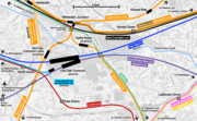 Map of the planned Old Oak Common station in relation to existing rail services
 -
 The West London line crosses Old Oak Common via Mitre Bridge (pictured here in 1979)


References
- ^ Samuda, J. D'A (1841), A Treatise on the Adaptation of Atmospheric Pressure to the Purposes of Locomotion on Railways. London: John Weale, 59 High Holburn.
- ^ Lemon, Mark; Mayhew, Henry; Taylor, Tom; Brooks, Shirley; Burnand, Francis Cowley; Seaman, Owen (1849). "Punch's Railway Intelligence". Punch. p. 113. Retrieved 29 May 2020.
- ^ "Another Punch at Punch's Railway". Punch. 1850. Retrieved 29 May 2020.
- ^ The Kensington Canal, railways and related developments, Survey of London: volume 42: Kensington Square to Earl's Court (1986), pp. 322-338. Date accessed: 2 September 2008.
- ^ "London's Iron Belt". The St. James's Magazine and United Empire Review. A.H. Moxon. 1861. p. 265.
Some of my readers may have noticed a rusty weed-grown line of railway, running under the high road near Hammersmith Turnpike...it starts from no place in particular, and can hardly be said to have had any definite destination. It had no traffic, except an occasional coal truck...on the whole, nobody could comprehend why such a line ever was made, and of what use it was when made. Now, however, a brighter future is before it...the highly important duty of connecting the railways on the north of the Thames with the railways and terminal points on the south.
- ^ Nick Catford, West London Junction, Subterranea Britannica disused station project, August 2009. Accessed 28 January 2010.
- ^ "Willesden: Economic history | British History Online".
- ^ "Chelsea & Fulham". Disused Stations. Subterranea Britannica. Retrieved 15 August 2013.
- ^ Hallet, Graham (July 2020). "Bringing home the milk". Great Eastern Journal. 183: 14, 15.
- ^ Passengers No More by G.Daniels and L.Dench second edition page 47
- ISBN 978-0-19-926909-9.)
{{cite book}}: CS1 maint: multiple names: authors list (link - ^ "Memorandum by Inter-Capital and Regional Rail Ltd (RES 4)". Parliamentary Debates (Hansard). Parliament of the United Kingdom: House of Commons (Select Committee on Environment, Transport and Regional Affairs). 26 January 1999. p. Appendices Section 4.
- ^ "Naming London Overground lines". Transport for London. Retrieved 11 February 2024.
- ^ "London Overground lines to be given unique names". BBC News. 25 August 2023. Retrieved 11 February 2024.
- ^ London Overground: New names for its six lines revealed, BBC News, 15 February 2024
- ^ "Kensington Olympia". Disused Stations. Subterranea Britannica. Retrieved 19 August 2013.
- ^ Elliott, Emily-Ann (12 October 2008). "Train services from Brighton withdrawn". The Argus. Brighton. Archived from the original on 7 October 2012. Retrieved 19 August 2013.
- ^ CrossCountry. "Frequently Asked Questions: How will the timetable change and when?". Archived from the original on 22 August 2008.
- ^ "DIRECT WEST LONDON LINE SERVICE TO SOUTH LONDON STATIONS" (PDF). West London Line Group. Retrieved 19 August 2013.
- ^ "CROSS-CLAPHAM WEST LONDON LINE SERVICES AT RISK……AGAIN!" (PDF). West London Line Group. Retrieved 19 August 2013.
- ^ "Cross London Route Utilisation Strategy" (PDF). Network Rail. August 2006. p. 14. Retrieved 2 December 2012.
- ^ "South Central Franchise Consultation" (PDF). Department for Transport. May 2008. p. 36. Archived from the original (PDF) on 8 August 2008. Retrieved 2 December 2012.
- ^ Changes to National Rail Timetable National Rail 15 May 2022
- ^ "Station Usage". Rail Statistics. Office of Rail Regulation. Retrieved 26 April 2012.
- ^ "Estimates of Station Usage 2015-16" (PDF). Office for Rail and Road. 5 December 2016. Archived (PDF) from the original on 3 June 2019. Retrieved 20 March 2024.
- ^ "High Speed Rail" (PDF). Department for Transport. p. 107. Archived from the original (PDF) on 13 May 2010. Retrieved 7 January 2011.
- ^ Terry Farrell (August 2011). "A Vision for Park Royal City" (PDF). London Borough of Hammersmith & Fulham. pp. 21 & 34. Archived from the original (PDF) on 24 April 2012. Retrieved 17 June 2013.
- ^ "Old Oak Common Station" (PDF). High Speed Rail Consultation. Department for Transport. Retrieved 14 June 2013.
- ^ Peter Moth – Principal Transport Planner, TfL. "High Speed 2 – Old Oak Common station proposals" (PPT). Retrieved 11 July 2013.
- ^ "Old Oak Common: A Vision and Challenge For Crossrail (Part 1)". London Reconnections. 9 July 2013. Retrieved 11 July 2013.
- ^ "West London Line cocooned by Earls Court development". London Reconnections. 13 June 2013. Retrieved 14 June 2013.
Further reading
- Nisbet, A F. (2006), "Punch's Railway and the Winkle Railway", BackTrack, 20 (2 Feb)): 117 to 121.
- Thomas Faulkner (1839), The History and Antiquities of the Parish of Hammersmith, pp 65–68.
- J.B. Atkinson "The West London Joint Railways" Ian Allan 1984.
- Vic Mitchell and Keith Smith "West London Line – Clapham Jn. to Willesden Jn." London Suburban Railways Series, Middleton Press 1996.
External links
- West London Line Group, representing the interests of users of the West London line.
- West London Line from abandonedstations.org.uk
- "Disused Stations". Subterranea Britannica. Detailed pages on the history of each station on the line (current and disused).
 Media related to West London Line at Wikimedia Commons
| Main lines |
|  | ||||
|---|---|---|---|---|---|---|
| Branch | ||||||
| Disused | ||||||