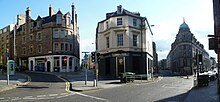
West Port, Edinburgh
 Main Point, the historic junction of the three roads (2nd l. to r.) to Biggar, Glasgow and Stirling | |
| Former name(s) | Wester Portsburgh |
|---|---|
| Length | 0.2 mi (0.32 km) |
| Coordinates | 55°56′47″N 3°12′00″W / 55.94639°N 3.20000°W |
| west end | Main Point |
| east end | Grassmarket |
The West Port is a street in
The street takes its name from the westernmost of the "ports" or
The history of the street


Historic names for the street and area
Wester Portsburgh, as the area around the West Port was formerly known, was the main street through the western part of the burgh of Portsburgh[2] - a burgh of barony from 1649[3] to 1856.[4]
The name West Port originally referred only to the gate itself, but was used for the entire length of the street leading away from the gate in maps from around 1837 onwards.[5] Wester Portsburgh still appeared as the name of the street on maps as late as 1831.[6]
Portsburgh can also be seen as the name for the same street in a map from 1836.
Historic events and famous residents
- King Charles I entered Edinburgh by the West Port in the year of his Scottish Coronation, 1633.
- "In 1650, when an English invasion was expected, many houses in Potterrow, as well as the West Port, were demolished by order of the magistrates, that the guns of the castle, and those on the city wall might have free action to play upon the enemy".[9]
- According to the poem by Netherbow Port.
- The Porteous Riots started with a mob at Portsburgh.
- Confessions of a Justified Sinner that he had lodgings in Portsburgh.[10]
- The West Port murders were so named as many of the victims were tempted back to Hare's lodgings in Tanner's Close, off the West Port, to be murdered.[11]The site is now occupied by Argyle House.
- The "West Port Experiment" was a model for parochial engagement, conceived by Thomas Chalmers, with a church/school built on the south side of the street to facilitate this.[12]
Recent history and the modern-day street

- Portsburgh Church is on a buildings at risk register.[13]
- The Vennel off the junction of West Port and the Grassmarket was used in the film 'The Prime of Miss Jean Brodie' (1969) when Brodie takes her girls on a walk through the Old Town, ending up in Greyfriars Kirkyard.
Notable buildings still in existence
Buildings built before the 21st Century
The
The name of Portsburgh Square[17] on the north side of West Port is a reminder of the area's former name.
21st Century developments

Dominating the north side of the West Port at its junction with Lady Lawson Street is Argyle House, built in 1968 to designs by Michael Laird and Partners.[18] Long used as local and national government offices, it now houses CodeBase, the largest tech incubator in Scotland, University of Edinburgh offices, along with various other businesses.
Evolution House, the newest building of the Edinburgh College of Art stands on the south east corner of West Port and Lady Lawson Street.[19]
Westport 102 was constructed on the West Port side of the block between Lady Lawson Street and Lauriston Street
See also
References
- ^ "Heriot Place and Vennel, Bastion of Flodden Wall, and Telfer Wall (Section)". Historic Environment Scotland. Retrieved 10 February 2024.
- ^ 'Portree - Pulteney Town', A Topographical Dictionary of Scotland. 1846. pp. 388–396. Retrieved 17 May 2008.
- ^ Parliamentary register of Portsburgh being declared a burgh in 1649
- ^ Portsburgh Burgh Edinburgh through time | Administrative history of Scottish Burgh: hierarchies, boundaries
- ^ Map of The City of Edinburgh, published in 1837
- ^ Plan of the City of Edinburgh, including all the latest and intended improvements, 1831 imprint[permanent dead link]
- ^ Kay's plan of Edinburgh, 1836 imprint
- ^ [Caledonian Mercury (Edinburgh, Scotland), Saturday 17 November 1885, Issue 20636]
- ^ Ch 38: Bristo and the Potterrow - Old and New Edinburgh by James Grant - Volume IV
- ^ The Private Memoirs and Confessions of a Justified Sinner / Hogg, James, 1770-1835
- ISBN 1-84158-309-X.
- ^ The West Port Experiment, Newble.co.uk
- ^ Trust targets six derelict properties it wants to see brought back to life - Edinburgh Evening News
- ^ Photos and history of The Vennel
- ^ Details of the architectural history of the Salvation Army Women's Hostel
- ^ Permission granted for change of us for the Salvation Army Women's Hostel to serviced apartments
- ^ An old photo of Portsburgh Square
- ^ "Welcome to Edinburgh".
- ^ Details of Evolution House, built on the corner of West Port and Lady Lawson Street
- ^ New vision for post office HQ is unveiled - Scotsman.com Business
- ^ BBC NEWS | Scotland | Edinburgh and East | Roads closed by building collapse

