
West Region (Cameroon)
West Region | |
|---|---|
| Government | |
| • Governor | Awa Fonka Augustine |
| Area | |
| • Total | 13,892 km2 (5,364 sq mi) |
| Population (2019) | |
| • Total | 2,770,400 |
| • Density | 200/km2 (520/sq mi) |
| HDI (2017) | 0.603[1] medium · 4th of 10 |
The West Region (French: Région de l'Ouest) is 14,000 km2 of territory located in the central-western portion of the Republic of Cameroon. It borders the Northwest Region to the northwest, the Adamawa Region to the northeast, the Centre Region to the southeast, the Littoral Region to the southwest, and the Southwest Region to the west. The West Region is the smallest of Cameroon's ten regions in area, yet it has the highest population density.
As home to the enterprising Bamum and Bamileke kingdoms, the West is an economic bright spot and one of Cameroon's more developed regions. This progressive development is tempered by the strong traditional culture that persists among the Bamileke and the province's other major ethnic group, the Bamum (sometimes Bamoum, Bamun, Bamoun).
Geography
Land
The West sits at the geologic crossroads of Cameroon; the soil varies greatly within a relatively small land area. The land along the
Drainage
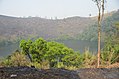
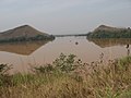
The West's mountainous terrain and active tectonics create many fast-moving rivers with picturesque falls and isolated crater lakes. These rivers follow a Cameroon regime, experiencing a period of high waters during the wet season and a period of low waters in the dry period. The rivers all form part of the Atlantic basin.
The
.Most of the West's lakes are crater lakes formed from collapsed
-
 Lake Baleng
 -
 Nkam River
 -
 Lake Monoun
 -
 Mbam River
 -
 Metche falls
 -
 Bangoua Falls


Relief
The Bamboutos Mountains are the West's primary land feature. Elevations reach as high as 2,000 metres and dip as low as 500 metres in the Noun and Nkam valleys. The highest point is
Climate
High elevations and moderate to high humidity give the West one of Cameroon's more pleasant climates. Temperatures average a cool 22˙, and rainfall is moderate. Except for the southeasternmost portions, the West experiences two major seasons in lieu of the traditional four: the year begins in a long, dry period of little rain, which runs until May, then the rains begin in May or June and last until October or November. Though the transition is gradual, the southeastern reaches of the province are part of the South Cameroon Plateau and thus have four seasons: the long dry season from December to March, the short rainy season from March to June, the short dry season from June to August, and the long rainy season from September to December.
The climate is
type in the southeastern two-thirds. Rainfall, moderated by the mountains, averages 1,000-2,000 mm per year throughout, though it is highest at the area of the Bamendjing Reservoir.Plant and animal life
Very little of the West's original flora or fauna survives, since most land has been cleared by human farmers. This is particularly evident on the Western High Plateau, where poor soil and less rainfall have exacerbated the effects of
East of the Noun River, the terrain is primarily covered in woodland

Demographics
| Year | Pop. | ±% p.a. |
|---|---|---|
| 1976 | 1,035,597 | — |
| 1987 | 1,339,791 | +2.37% |
| 2005 | 1,720,047 | +1.40% |
| 2015 | 1,921,590 | +1.11% |
| source:[2] | ||
Settlement patterns

The West's population density is high in general, especially in the towns of Bafoussam, Dschang, Mbouda, and Bafang. This is due to the pleasant climate and fertile soils. Bafoussam is both the provincial capital and the centre of the Bamileke lands. Populations thin out toward the southern border and in the eastern Bamum-dominated territories. Settlements are scattered.
The region experiences significant out-migration, particularly when the vast plantations of the Southwest Province hire workers for annual harvests. Permanent emigration is mainly by those who wish to escape the overcrowded conditions and to farm larger pieces of land, and is directed mainly to the Southwest and Littoral Provinces.
Bamileke homes are traditionally made of dried earth placed on a bamboo frame and covered by a thatched roof. Farm plots separated by fences surround the typical home. Houses of this type are seldom seen today, however, though barns are still constructed using these methods. The last bastion of traditional architecture are the many chiefs' compounds that dot the province. These are characterized by their tall, conical roofs, bamboo and clay-brick walls, and carved poles around the entryway. The typical layout places a central audience chamber in front of other rooms for individuals of progressively lower rank.

People
Two major tribal groups dominate the West: the Bamileke and the Bamum. Both of these are considered
The
Other languages spoken in the province include
Economy
The West is one of Cameroon's soundest economic areas due primarily to its agricultural prosperity and the enterprising traditions of the Bamileke people. In areas that do not have a daily market, market days are typically every eighth day (the Bamileke follow an eight-day week).
Agriculture
Subsistence farming

The Bamileke are skilled farmers who exploit virtually every strip of land available.[citation needed] Along with the neighbouring Northwest Province, the West supplies most of the food consumed in Cameroon's seven lower provinces. Tools are largely traditional. Farmers plant after the first rains in fields consisting of alternating ridges and furrows. In the past, farmers practiced field rotation, allowing land to lie fallow for two or three years. Due to increasing population density, however, they use the land almost continuously today; the loss in fertility is partially countered through extensive use of fertilisers and manure. Hedges or fences that separate private plots and keep out animals surround farms in the West. These hedges also provide firewood and help prevent from soil erosion. In the Southeast, farmers sometimes place fields in forest clearings where they use slash-and-burn agriculture.
Plantation agriculture
Population pressures prevent entrepreneurs from establishing large plantations more prevalently in the West. Coffee is the major cash crop, with large fields in the regions of Bafoussam, Foumbot, and Dschang and powerful supervision by Union des Cooperatives de Café Arabica de l'Ouest (UCCAO). Cocoa is also important, particularly in the lowlands. Tea is grown commercially near Dschang. Some rice cultivation takes place under the Upper Noun Development Company (UNVDA) in the southeast, largely due to government projects. Tobacco from Mbouda and Foumbot stays within the province for local consumption, though the Bastos Company of Yaoundé processes some for export.
Livestock
Many farmers raise sheep and goats in the southeastern half of the province. Increasingly common these days are poultry and pigs, which can live in pens on smaller farms. In fact, the majority of Cameroon's pork comes from the region, and a large government-run poultry farm operates at Kounden. Smallholder farmers, especially women, keep domestic cavies in their homesteads that may provide more protein to family nutrition than any other meat source.[3][4]
The Bamendjing is also the site of traditional fishing, and professional fisheries operate at Foumban.

Industry
The West is home to relatively little
Arts and crafts form the heart of the West's production. Particularly renowned are the goods produced by Bamum
Transportation
With such a small land area and large network of mostly paved roads, the West is one of Cameroon's more accessible provinces. Major routes through the area include National Road 4 to Yaoundé, National Road 5 from
Tourism
With its legions of artisans and its lavish sultan's palace, Foumban forms the West's main tourist draw. Visitors also come to experience the region's magnificent scenery and rich traditional culture.
Administration and social conditions
The West's high population and economic dominance lend it great political importance. However, Cameroon's government and state-run media, largely run by President Paul Biya's numerically inferior Beti-Pahuin tribal group, are often accused of anti-Bamileke bias. The Bamileke thus stand to gain a great deal from a more free and transparent government, and the West harbors many sympathisers for the presidential party's main opponents, the Social Democratic Front.
Government

The West consists of eight divisions or
The departments are:
The
Traditional political organisation
Traditional rulers still hold substantial power in the province. A sultan, whose palace and head of government are in Foumban, rules the Bamum. Bamum tradition claims an unbroken line of succession since 1394.
The Bamileke, in contrast, are divided into over 100 groups, each headed by a chief (fon, foyn, or fo). The chiefs are themselves divided into various ranks, with major rulers living in Bandjoun, Bafang, Bangangté, Dschang, and Mbouda. Traditionally, chiefs command divine powers and own all lands by divine mandate. Individual tenants work plots at their chief's behest. These groupings thus form the basis for Bamileke tribal identity. Advisers, often called the “Council of Notables”, in turn serve the chiefs. Below them are various district chiefs who govern individual wards in the village.
Education
With nearly 1,000 schools serving its some 1,000 villages, the West relatively well provisioned educationally. The high population density contributes to
Health
Hospitals and health clinics are fairly prevalent in the region. The area's pleasant climate keeps it largely mosquito-free, so
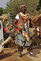
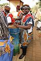
Cultural life
The West has a lively traditional culture. The Bamum observe traditional Muslim holy days, such as Ramadan and the Feast of the Ram. They also hold an annual cultural festival called the Ngouon. Bamileke festivals vary from tribe to tribe, and most are held during the dry season or for special events such as funerals or the birth of twins. Some examples are the Macabo Festival of Bangoua, the Medumba Festival of Bangangté, and the Ben Skin Dance, a dance of female sensuality that has grown increasingly commercialised.
A number of museums celebrate the West's history and traditions. Among these are the Musée du Palais du Sultan Bamun, the Musée des Arts et des Traditions Bamoun, and the Musée Sacré Djissé, all in Foumban. The Musée de la Chefferie Bandjoun is the region's largest repository of Bamileke artifacts.
History
Early population movements
Human beings have inhabited the West since prehistoric times, as evidenced by archaeological finds at Galima and Foumban. Bamileke groups likely entered the area from the Adamawa Plateau in the 17th century, probably fleeing Fulbe (Fula) slave raids. They originally settled in what is now Bamum territory, but the Bamum forced them across the Noun in a series of wars in the 18th century. Bamileke tradition states that they migrated in three major groups. The first consisted of the Baleng, Bapi, and Bafussam (who founded the settlement at Bafoussam along with the Bamougoum). Next came the Bagam, Bamendu, Bamsoa, Bazu, and Bangu. The final wave consisted of the Bati and Bafangwa. This period also saw the Bamileke assimilation of several older populations.
Bamum tradition claims their kingdom was founded when Ncharé Yen led them to settle at Foumban (Mfom-Ben) in the 15th century. However, most scholars today place this migration as late as the 19th century, likely the result of population pressures caused by the same Fulbe jihads that had earlier pushed the Bamileke south. The king Mbwe-Mbwe extended Bamum holdings from the Mbam to the Noun Rivers, subjugating numerous local rulers in the process. Mbwe-Mbwe also kept the Fulbe from encroaching further south and west.
The Bamum experienced a golden age of sorts under the leadership of Sultan Ibrahim Njoya (r. 1886–1933). Njoya was a patron of learning, and he converted to Islam under the tutelage of numerous Muslim scholars he had allowed into the kingdom. He developed an alphabet for the Bamum language (the Shumon script), and established schools to teach it. The Islamisation of the Bamum occurred during his reign.
The Bali-Chamba are the third major group to have pushed through the West Province territory in historical times. They came under the leadership of a warrior chief named Gawolbe and crossed the Noun around 1825. In 1830, they fought a war with the Bamileke Bafu-Fundong group near Dschang. Their leader, Gawolbe II died, and the tribe splintered as Gawolbe's seven sons fought for control. Most of these groups migrated further west into what is today the Northwest Province.
European contacts

German administration
The area had only indirect contact with European powers (mostly due to slave raids by tribes further south) before the
Sultan Njoya welcomed the first German emissary to the Bamum kingdom in 1902 after hearing of the ruthless treatment given rebellious tribes further to the northwest. He even lent military support for the German campaign against the Nso near Bamenda in 1906. The Bamum soldiers, eager for revenge for an earlier defeat to the Nso in 1888, committed such atrocities that the Germans sent them back. Njoya also ordered the building of a palace at Foumban in 1917, which he modeled after that of the German governor.
French administration
Bamileke and Bamum territory fell to the
The French continued Germany's policy of propping up sympathetic chiefs and deposing recalcitrant ones. They sought some sort of administrative centre amid the Bamileke domains, and in 1926, Fotso II of the Bandjoun people offered the site of Bafoussam, neighbouring his domains but not actually part of them. Mambou, chief of the area, opposed the colonials, but he was defeated, and the foundations of modern Bafoussam were laid. The Bamum did not escape the French sphere, either, as sultan Ibrahim Njoya was deposed in 1931 due to his pro-German views. Njoya died in a Yaoundé prison two years later.
After
In 1958,
Post-independence
Under Ahidjo, the current West Province was known as the Administrative Inspectorate of the West. He named Bafoussam the capital and set the province's current boundaries after union of British and French Cameroon in 1972.
Ahidjo's battles with the UPC continued past Cameroon's independence on 1 January 1960. He outlawed the party's "terrorist" wing on 30 October 1963, leading to more strikes in Bamileke population centres and subsequent military retribution.
What support Ahidjo did enjoy among the Bamileke largely came from his pro-business policies. When the president resigned in 1982, his replacement, Paul Biya, sent his representative, Moussa Yaya, to reassure the West's businessmen that he would not prove unfriendly to their interests. Yaya mistrusted Biya, however, and only exacerbated Bamileke reservations. The Bamum, as well, were reluctant to see Cameroon's presidency change from a Muslim to a Christian. Much Bamileke and Bamum resentment for the Biya administration dates to this period.
In 2008, the President of the Republic of Cameroon, Paul Biya, signed decrees abolishing "Provinces" and replacing them with "Regions". Hence, all of the country's ten provinces are now known as Regions.
Culture
Traditional dance accessories
-
 Mask
Mask

Traditional Dances
-
-

-

-
 Tam-Tam Player
 -

-

-
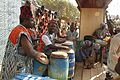 Tam-tam group players


Traditional musical instruments
-
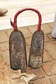
 Bamileke cowbells
 -
 Balafon
 -
 Another balafon
 -
 Tam-tam
 -
 Sanza
Sanza -
 Sanza
Sanza -
 Balafon
 -
 Balafon
 -

-


References
- ^ "Sub-national HDI - Area Database - Global Data Lab". hdi.globaldatalab.org. Retrieved 2018-09-13.
- ^ Cameroon: Administrative Division population statistics
- S2CID 17847427.
- ^ Ngou-Ngoupayou, J.D., Kouonmenioc, J., Fotso Tagny, J.M., Cicogna, M., Castroville, C., Rigoni, M. and Hardouin, J. 1995. Possibilités de développement de l'élevage du cobaye en Afrique subsaharienne: le cas du Cameroun. World Animal Review (FAO/AGA) 83(2): 21–28
- ^ Middleton, John; Miller, Joseph (2008). "Ahidjo, El Hajj Ahmadou (1924–1989)". New Encyclopedia of Africa. 1: 29–30.
Further reading
- Fanso, V.G., Cameroon History for Secondary Schools and Colleges, Vol. 1: From Prehistoric Times to the Nineteenth Century. Hong Kong: Macmillan Education Ltd, 1989.
- Neba, Aaron, Ph.D., Modern Geography of the Republic of Cameroon, 3rd ed. Bamenda: Neba Publishers, 1999.
- Ngoh, Victor Julius, History of Cameroon Since 1800. Limbé: Presbook, 1996.
| Noun |  | |
|---|---|---|
| Ndé | ||
| Haut-Nkam | ||
| Menoua |
| |
| Mifi |
| |
| Bamboutos | ||
| Hauts-Plateaux | ||
| Koung-Khi | ||
| Authority control databases: Geographic |
|---|