
Wheathampstead
This article needs additional citations for verification. (February 2013) |
| Wheathampstead | ||
|---|---|---|
Shire county | ||
| Region | ||
| Country | England | |
| Sovereign state | United Kingdom | |
| Post town | St Albans | |
| Postcode district | AL4 | |
| Dialling code | 01582 | |
| Police | Hertfordshire | |
| Fire | Hertfordshire | |
| Ambulance | East of England | |
| UK Parliament | ||
| Website | Wheathampstead Parish Council | |
Wheathampstead is a village and
History
Settlements in this area were made about 50 BC by Belgic invaders. They moved up the rivers Thames and Lea from what is now Belgium. Evidence for them was found in Devil's Dyke, at the eastern side of Wheathampstead. The Devil's Dyke earthworks are part of the remains of an ancient settlement of the Catuvellauni and thought to have been the tribe's original capital. The capital was moved to Verlamion (which after the Roman conquest the Romans would rename Verulamium, which in turn would become modern St Albans) in about 20 BC. Although silver Republican coins dating back to 100 BC are common finds around the verulam settlement. The Devil's Dyke is reputedly where Julius Caesar defeated Cassivellaunus in 54 BC, although this claim is disputed. Some historians suggest that the dyke was part of the same defensive rampart as nearby Beech Bottom Dyke, which, if correct, would make the area one of the largest and most important British Iron Age settlements.
Later, the village is recorded in the Domesday Book of 1086 under the name Watamestede. It appears that a church existed at Wheathampstead before the Norman Conquest, as Wheathampstead was given by Edward the Confessor to Westminster Abbey, but it is very difficult to determine whether any portion of the present St Helen's Church is of Saxon work. The original structure was demolished in the reign of Henry III, the oldest portion of the present church, in the chancel, is assigned to the year 1280.[2]
Some historians have claimed (
Up until 1859, Wheathampstead and

The village is also close to
Amwell

About 1 mile (1.6 km) to the southwest of Wheathamstead and lying within its civil and ecclesiastical parish, the
Transport
There was once a railway station serving the village but it closed in 1965 - a full amateur film of this line on the last day of operation can be seen on YouTube under the title "Welwyn Garden City, Harpenden East, Luton Hoo, Bute, Dunstable". Public transport is now provided by an hourly bus between Borehamwood and Harpenden, operated by Aylesbury-based bus company Red Rose Travel.[4] A half-hourly bus operated by Uno also runs through Wheathampstead between Luton and Hatfield.[5]
Notable residents
- Rudolph Lambart, 10th Earl of Cavan (1865–1946), Field Marshal and Chief of Imperial General Staff
- Apsley Cherry-Garrard (1886–1959), polar explorer
- Reginald Owen (1887–1972), character actor
- Nick Halling, TV presenter and sports journalist
- Nick Payne, playwright
- William Beach Thomas (1868–1957), author, journalist, war correspondent and writer about country life, lived here in later life and is buried here.
- Michael Ventris (1922-1956), linguist who deciphered Linear B
- Diane Munday, abortion activist
Images
-
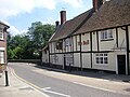 The Mill Bridge and the Bull public house
 -
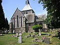 St Helen's Church
 -
 River Lea flowing through Wheathampstead


References
- ^ ONS, Census 2021 Parish Profiles
- ^ "St Helen's Church, Wheathampstead, history". www.wheathampstead.net.
- ^ "CONSERVATION AREA CHARACTER STATEMENT FOR AMWELL" (PDF). www.stalbans.gov.uk. St Albans City and District Council. January 2012. Retrieved 16 December 2021.
- ^ "Timetable 357 Borehamwood - Harpenden via St Albans & Wheathamsptead". Archived from the original on 27 March 2023. Retrieved 20 October 2023.
- ^ "610/612 | Uno". www.unobus.info.
Further reading
- Page, William (1908). A History of the County of Hertford, Volume 2. Victoria County History. pp. 294–314.
External links
| International | |
|---|---|
| National | |
| Geographic | |