
Wild Fields

The Wild Fields (
In a broad sense, it is the name of the entire
According to Ukrainian historian Vitaliy Shcherbak, the term appeared sometime in the 15th century for territory between the Dniester and mid-Volga when colonization of the region by Zaporozhian Cossacks started.[3] Shcherbak notes that the term's contemporaries, such as Michalo Lituanus,[4][5] Blaise de Vigenère, and Józef Wereszczyński,[6] wrote about the great natural riches of the steppes and the Dnieper basin.[3]
History
_eng.png)


Due to its location, this region has long been among the least populated in Europe. However, from the beginning of the I millennium BC to the middle of the II millennium AD, it became an arena of intense struggle between settled agricultural tribes and steppe nomads. Since ancient times, the nomadic way of life has prevailed in the Wild Fields, and settled life (civilization) was established with great difficulty. For centuries, the region was only sparsely populated by various nomadic groups such as Scythians, Sarmatians, Alans, Huns, Cumans, Khazars, Bulgars, Pechenegs, Kipchaks, Turco-Mongols, Tatars and Nogais.[7] There were Pontic Greek colonies on the Pontic steppes of the Wild Fields — Tanais, Olbia, Borysthenes, Nikonion, Tyras.
The rule of Great Khazaria on these lands was replaced by Kievan Rus, and Kievan Rus was replaced by the Mongol Empire. The steppes of the Wild Fields were suitable for the development of agriculture, animal husbandry, and crafts, which led to their colonization as early as the Kievan state. This was hindered by the raids of steppe nomads that roamed these lands in waves. After the Mongol invasion of Kievan Rus', the territory was ruled by the Golden Horde until the Battle of Blue Waters (1362), which allowed Algirdas to claim it for the Grand Duchy of Lithuania. As a result of the Battle of the Vorskla River in 1399, his successor Vytautas lost the territory to Temür Qutlugh, the khan of the Golden Horde.
After the devastation of these lands by the
The Wild Fields were traversed by the
What made the "wild field" so forbidding were the Tatars. Year after year, their swift raiding parties swept down on the towns and villages to pillage, kill the old and frail, and drive away thousands of captives to be sold as slaves in the Crimean port of
Podilia alone, about one-third of all the villages were devastated or abandoned between 1578 and 1583.[9]
.jpg)


In the 16th and 17th centuries, the government of the Polish-Lithuanian Commonwealth considered the Ukrainian lands to the east and south of Bila Tserkva to be the Wild Fields, and distributed them to magnates and nobility as private property as uninhabited, although Ukrainians lived there.
By the 17th century, the east part of the Wild Fields had been settled by runaway peasants and
The period of Hetmanate history known as "the
The period of the Ruin effectively ended when Ivan Mazepa was elected hetman, serving from 1687 to 1708. He brought stability to the Hetmanate, which was again united under a single hetman. During his reign, the Great Northern War broke out between Russia and Sweden. Mazepa and some Zaporozhian Cossacks allied themselves with the Swedes on October 28, 1708. The decisive battle of Poltava (in 1709) was won by Russia, putting an end to Mazepa's goal of independence, promised in an earlier treaty with Sweden. The Liquidation of the autonomy of the Cossack Hetmanate has begun.
During the reign of
After a series of Russo-Turkish wars waged by
In the 20th century, after the collapse of the USSR, the region was divided among Ukraine, Moldova, and Russia.[citation needed]
In 1917, the world's first anarchist state was formed on the territory of Wild Fields — Makhnovia
The territory of Wild Fields is located in the modern Dnipro, Donetsk, Zaporizhzhia, Kirovohrad, Luhansk, Mykolaiv, Odesa, Poltava, Kharkiv and Kherson oblasts of Ukraine.
See also
- European Plain
- New Serbia (historical province)
- Southern Ukraine
- Zaporozhian Sich
- Makhnovshchina
- Novorossiya
- High Plains
References
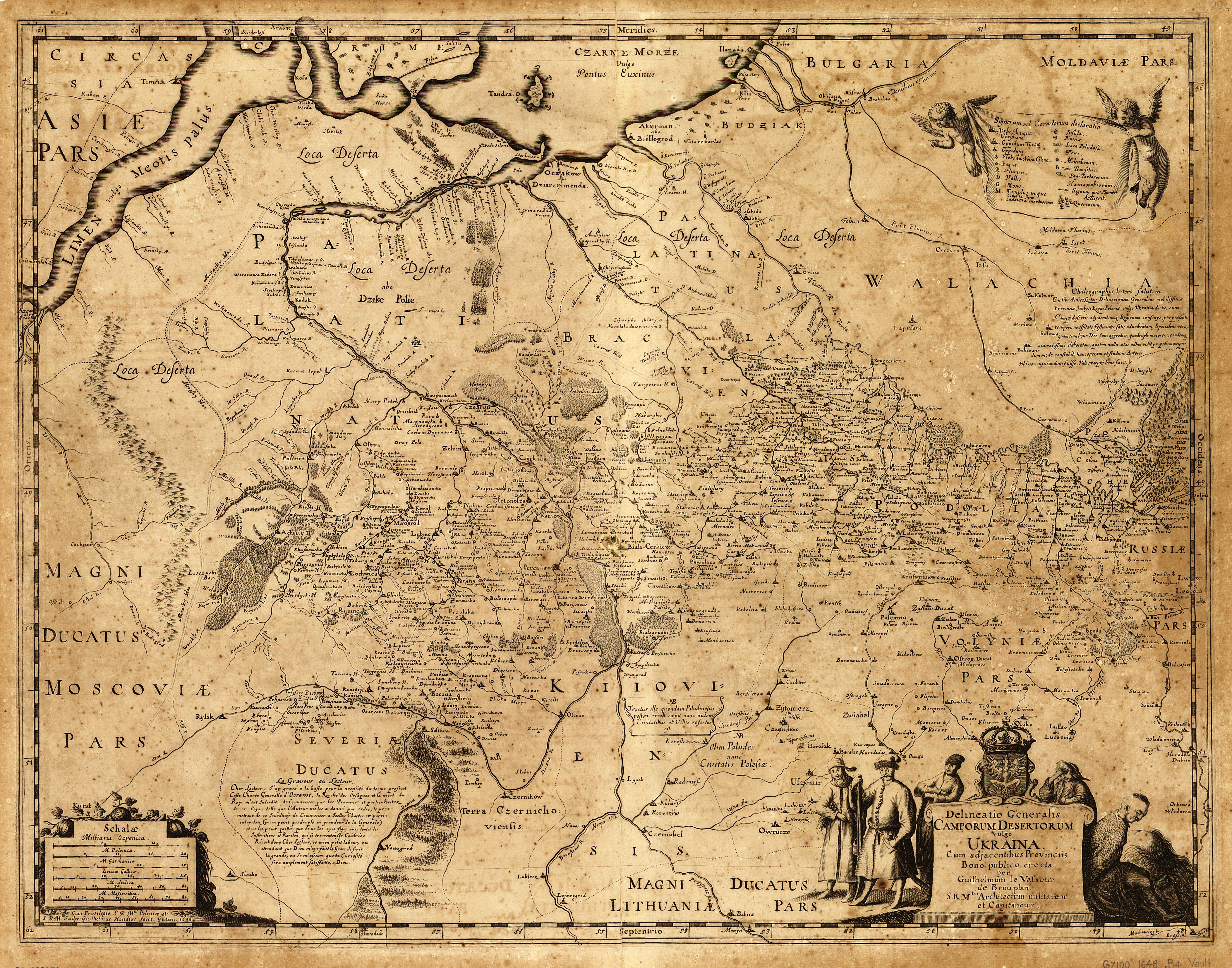
- ^ Camporum Desertorum vulgo Ukraina by Guillaume Le Vasseur de Beauplan, Cum Privilegio S.R.M. Poloniae. Gedani 1648; Campi Deserti citra Boristhenem, abo Dzike Polie Polish–Lithuanian, by Ian Jansson, c. 1663, Amsterdam
- ^ Дикі поля "Archived copy". Archived from the original on 2015-12-22. Retrieved 2023-08-14.
{{cite web}}: CS1 maint: archived copy as title (link) CS1 maint: bot: original URL status unknown (link) — Енциклопедія українознавства : Словникова частина : [в 11 т.] / Наукове товариство імені Шевченка ; гол. ред. проф., д-р Володимир Кубійович. — Paris — New-York : Молоде життя, 1955—1995 // Т. 2. — 1957. — С. 509-524 - ^ a b c Shcherbak, V. Wild Field (ДИКЕ ПОЛЕ). Encyclopedia of History of Ukraine. 2004
- ^ De Moribus Tartorum
- ^ "Michalo Lituanus, De moribus Tartarorum, Lituanorum et Moscorum fragmina X, multiplici historia referta, 1550". Archived from the original on 2021-01-31. Retrieved 2018-09-19.
- ^ a b Sas, P. Duchy of the Zaporizhian Host, the project of Józef Wereszczyński (КНЯЗІВСТВО ВІЙСЬКО ЗАПОРОЗЬКЕ, ПРОЕКТ ЙОСИПА ВЕРЕЩИНСЬКОГО). Encyclopedia of History of Ukraine
- ISBN 081087847X
- ISBN 978-1472514158.
- OCLC 940596634.
- ISBN 9789004254404. Retrieved 18 April 2018 – via Google Books.
- JSTOR 10.7591/j.ctvrf8ch7.
- ISBN 978-0-8108-7847-1. Retrieved 3 August 2015.
External links