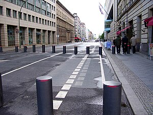
Wilhelmstrasse

Wilhelmstrasse (
Course
The Wilhelmstraße runs south from the Spree riverside through the historic Dorotheenstadt quarter to the Unter den Linden boulevard near Pariser Platz and Brandenburg Gate, where it takes on a line slightly east of south through adjacent Friedrichstadt, until its juncture with Stresemannstraße near Hallesches Tor in Kreuzberg, an overall distance of about 2.4 km (1.5 mi).
Further south of Unter den Linden it passes the nowadays built-over former Wilhelmplatz vis-à-vis Voss-Straße, it crosses Leipziger Straße near Leipziger and Potsdamer Platz, and Niederkirchnerstraße, known until after World War II as Prinz-Albrecht-Straße. At its southern end, Wilhelmstraße originally met with Friedrichstraße, which runs roughly parallel to the east, on the Belle-Alliance circus, before the street course was westerly redirected to the Stresemannstraße junction about 1970.
Between Unter den Linden and parallel Behrenstraße, the road is closed for motor vehicles as a protection of the Embassy of the United Kingdom.
History
Government district

Originally a wealthy residential street, with a number of palaces belonging to members of the Hohenzollern royal family, the Wilhelmstrasse developed as a Prussian government precinct from the mid 19th century. In 1858 King Frederick William IV acquired the former Palais Schwerin on No. 73. This building now called Palace of the Reich President housed an administrative seat of the Prussian minister for the Royal Household, from 1861 led by Alexander von Schleinitz. In 1869 the nearby Palais Schulenburg residence of late Prince Antoni Radziwiłł, built in 1738/39 on No. 77, was purchased by the Prussian state government at the behest of Schleinitz' opponent Minister-President Otto von Bismarck. Rebuilt from 1875 until 1878, it served as his official seat as German chancellor. The next door building on No. 76 was used for the chancellery's Foreign Office department.
Several further governmental departments took their seat on Wilhelmstrasse, such as the
Weimar Republic and Nazi years

After World War I the Palais Schwerin was sold by exiled Emperor
The Foreign Office moved into the former Reich President's palace, the old building being refurbished in grandiose style at the behest of Nazi Minister
Cold War

After the war, Wilhelmstrasse as far south as Niederkirchnerstrasse was in the Soviet sector of Allied-occupied Berlin, and apart from clearing the rubble from the street little was done to reconstruct the area until the founding of the German Democratic Republic (GDR) in 1949, with East Berlin as its capital. One of the earliest reconstructions was the 1948-built provisional wooden church hall of the Moravian Brethren congregation on Wilhelmstrasse 138.
The
The building of the
Today

Today, the Wilhelmstraße is an important traffic artery, but has not regained its former status. Since
The British Embassy, whose original building had been destroyed by bombing, was rebuilt on the site.
Many of the occupants of the GDR apartment blocks are recent immigrants, and there are a number of shops and restaurants catering to
Notes
- George Frost Kennan. The Oxford Illustrated Dictionary gives only this spelling; so do the Second Edition of the Oxford English Dictionary, and all five of its quotations.
- ^ See Daisy, Princess of Pless by Herself, p. 63. OED, "Wilhelmstrasse"
External links
 Media related to Wilhelmstraße (Berlin-Kreuzberg/Mitte) at Wikimedia Commons
- Wilhelmstrasse in Berlin online street maps
- The Historical Wilhelmstraße (in German)
- Wilhelmstraße during the Third Reich and today
- reconstructed Wilhelmstraße 62 and 76-80
