
Wilson River (New South Wales)
| Wilson River | |
|---|---|
NSW North Coast | |
| District | Mid North Coast |
| Local government area | Port Macquarie-Hastings |
| Physical characteristics | |
| Source | Mount Banda Banda |
| • location | in Willi Willi National Park |
| • elevation | 554 m (1,818 ft) |
| Mouth | confluence with the Maria River |
• location | Telegraph Point, north of Wauchope |
| Length | 69 km (43 mi) |
| Basin features | |
| River system | Hastings River catchment |
| Tributaries | |
| • left | Glencoe Creek |
| National park | Willi Willi NP |
| [1] | |
Wilson River, a perennial river of the Hastings River catchment, is located in the Mid North Coast region of New South Wales, Australia.
Course and features
Wilson River rises on the south-eastern slopes of
course.[1]
Glencoe Creek
is a tributary.
-
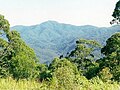 Mount Banda Banda headwaters of the Wilson River, to the west ofRollands Plains.
 -
 Wilson River at foot of Mount Cogo west of Port Macquarie

.png)
See also
- Rivers of New South Wales
- List of rivers of New South Wales (A–K)
- List of rivers of Australia
- Wilson River (disambiguation)
References
- ^ a b "Map of Wilson River, NSW". Bonzle Digital Atlas of Australia. Retrieved 2 March 2013.
External links
- "Camden Haven and Hastings River catchments" (map). Office of Environment and Heritage. Government of New South Wales.
River systems and rivers of the Northern Rivers catchments, New South Wales, Australia | |
|---|---|
| Tweed Shire and Tweed River | |
| Byron Shire and Brunswick River | |
| Richmond Valley and Richmond River | |
| Clarence Valley and Clarence River |
|
| Coffs Harbour, Bellingen Shire, and Bellinger River | |
| rivers | |
| Port Macquarie-Hastings and Hastings River | |
28°31′10″S 153°21′17″E / 28.51944°S 153.35472°E