
Wintersburg, Arizona
Wintersburg, Arizona | ||
|---|---|---|
FIPS code 04-84000 | | |
Wintersburg is an
unincorporated community and census-designated place in Maricopa County, Arizona, United States, located 48 miles (77 km) west of downtown Phoenix and 17 miles (27 km) west of Buckeye along Salome Highway. It is 4 miles (6 km) south of Exit 98 on Interstate 10. As of the 2020 census, Wintersburg had a population of 51,[2]
down from 136 in 2010.
Wintersburg is home to the Palo Verde Nuclear Generating Station, the largest nuclear power plant in the United States.
Demographics
| Census | Pop. | Note | %± |
|---|---|---|---|
| 2010 | 136 | — | |
| 2020 | 51 | −62.5% | |
| U.S. Decennial Census[3] | |||
As of the
Latino
of any race.
Images of Wintersburg
These are some images of Wintersburg
Wintersburg
-
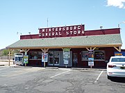 General store
 -
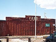 Feed store
 -
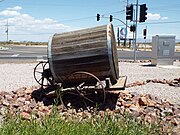 19th century water barrel cart


References
- ^ "2021 U.S. Gazetteer Files: Arizona". United States Census Bureau. Retrieved May 18, 2022.
- ^ a b "Wintersburg CDP, Arizona: 2020 DEC Redistricting Data (PL 94-171)". U.S. Census Bureau. Retrieved May 18, 2022.
- ^ "Census of Population and Housing". Census.gov. Retrieved June 4, 2016.
- ^ United States Census[dead link]
 | ||||
Towns | ||||
| CDPs | ||||
| Populated places |
| |||
| Indian reservations | ||||
| Ghost towns/ former populated places | ||||
| Footnotes | ‡This populated place also has portions in an adjacent county or counties | |||
| ||||
| International | |
|---|---|
| National | |