
Wisconsin River
| Wisconsin River | |
|---|---|
 Wisconsin and the Wisconsin River | |
| Location | |
| Country | United States |
| State | Wisconsin |
| Physical characteristics | |
| Source | |
| • location | Lac Vieux Desert |
| • elevation | 1,683 ft (513 m) |
| Mouth | |
• location | Mississippi River near Prairie du Chien, Wisconsin |
• coordinates | 42°59′22″N 91°09′14″W / 42.98944°N 91.15389°W |
| Length | 420 mi (680 km) |
| Basin size | 12,280 sq mi (31,800 km2) |
| Discharge | |
| • average | 12,000 cu ft/s (340 m3/s) at mouth |
| Official name | Lower Wisconsin Riverway |
| Designated | 14 February 2020 |
| Reference no. | 2417[1] |
The Wisconsin River is a
The Wisconsin River originates in the forests of the North Woods Lake District of northern Wisconsin, in Lac Vieux Desert near the border of the Upper Peninsula of Michigan. It flows south across the glacial plain of central Wisconsin, passing through Wausau, Stevens Point, and Wisconsin Rapids. In southern Wisconsin, it encounters the terminal moraine formed during the last ice age, where it forms the Dells of the Wisconsin River. North of Madison at Portage, the river turns to the west, flowing through Wisconsin's hilly Western Upland and joining the Mississippi approximately 3 miles (4.8 km) south of Prairie du Chien.
The highest waterfall on the river is Grandfather Falls in Lincoln County. It creates the borders between Adams, Juneau, Columbia, Sauk, Dane, Iowa, Richland, Grant, and Crawford Counties.
Geology

The modern Wisconsin River was formed in several stages. The lower, westward-flowing portion of the river is located in the unglaciated Driftless Area, and this section of the river's course likely predates the rest by several million years. The lower reach of the river is narrower than its upstream valley, leading to the suggestion that the upper portions of the ancestor of the river flowed east before the Pleistocene.[2]
The remaining length of the river was formed gradually as glaciers advanced and retreated over Wisconsin. The stretch of river from Stevens Point north to
History
This section's tone or style may not reflect the encyclopedic tone used on Wikipedia. (May 2012) |
This article needs additional citations for verification. (May 2012) |
In 1673, French missionary
Industry began to form on the Wisconsin in the early 19th century, as loggers started using the river to raft logs downstream from northern forests to sawmills in new cities like Wausau. By the 1880s, logging companies were damming the river to ensure the river had enough capacity for the logs being floated downstream. Later, at the start of the 20th century, more dams were constructed to provide for flood control and hydroelectricity. The dams also spurred tourism, creating reservoirs such as Lake Wisconsin that are popular areas for recreational boating and fishing. Today, the Wisconsin River is the hardest working river in the nation. There are 25 operating hydroelectric power plants on the Wisconsin River. The power plants harness 645 feet of the river's falls to generate nearly one billion kilowatt-hours of renewable electricity a year — enough energy to supply the residential needs of over 300,000 people without creating any pollution.
Despite this, a 93-mile (150 km) stretch of the Wisconsin between its mouth and the Prairie du Sac Dam is free of any dams or barriers and is relatively free-flowing. In the late 1980s, this portion of the river was designated as a state riverway, and development alongside the river has been limited to preserve its scenic integrity.
In 2018, a railroad bridge in Sauk City was removed.
Gallery
-
 Dells of the Wisconsin River, May 2002.
 -
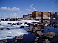 A dam in Stevens Point
 -
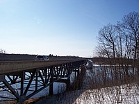 Highway 82 bridge over the Wisconsin River
 -
 Boating on the Wisconsin River
 -
 Delta at the Mississippi River, seen from Wyalusing State Park
 -


The Wisconsin River is a "navigable river of the United States." This designation primarily means that the federal government has jurisdiction for dams on the river. Dams that include hydropower facilities are regulated by the
Lower Wisconsin River State Riverway
The
There are no dams or man-made obstructions to the natural flow of water between the hydroelectric dam just north of Sauk City and the confluence of the Wisconsin and the Mississippi. This long stretch of free-flowing river provides important natural habitats for a variety of wildlife, including
, and a variety of fish species.Recreational opportunities on the lower Wisconsin River range from fishing and canoeing to tubing and camping. Canoe camping is particularly popular because of the abundance of suitable sandbars along the riverway and because no permits are required. On summer weekends,
Cities and villages along the river
See also
- List of Wisconsin rivers
References
- ^ a b "Lower Wisconsin Riverway". Ramsar Sites Information Service. Retrieved 25 September 2020.
- ^ Steven Dutch, "Possible Early Pleistocene Drainage in Wisconsin" Archived 2007-09-27 at the Wayback Machine, Retrieved July 17, 2007
- ^ "Louis Joliet - The Famous Journey". The Mariners' Museum. Retrieved 13 May 2014.
- ^ "Wisconsin's Name: Where It Came From and What It Means | Wisconsin Historical Society". www.wisconsinhistory.org. 12 February 2013. Retrieved 2017-06-29.
- ^ Wisconsin Public Service Corp. v. Federal Power Commission 147 F.2d 743 (1945).
- ^ "National Rivers: Wisconsin River Law, on river conservation, river access, paddling, canoeing, kayaking, rafting, fly-fishing, and Wisconsin river ownership". Archived from the original on 2012-02-07. Retrieved 2021-10-16.
- ^ "Lower Wisconsin State Riverway". Wisconsin Department of Natural Resources. Retrieved 13 May 2014.
External links
- River Alliance of Wisconsin
- Report on the Wisconsin River by Mark Morgan Archived 2003-08-03 at the Wayback Machine
- Wisconsin's Name: Where It Came From and What It Means Archived 2005-10-28 at the Wayback Machine, Wisconsin Historical Society
- Lower Wisconsin State Riverway Board
- Pictures and Information of the Northern Stretch of the Wisconsin River
- Current Wisconsin River Conditions
- Lower Wisconsin River Maps and Mileage
- . The American Cyclopædia. 1879.
- Kent, Paul G. and Dudiak, Tamara A. Wisconsin Water Law: A Guide to Water rights and Regulations, Second Edition (University of Wisconsin Extension, 2001).
| International | |
|---|---|
| National | |