
Wraysbury River
Wraysbury River | |||||||||||||||||||||||||||||||||||||||||||||||||||||||||||||||||||||||||||||||||||||||||||||||||||||||||||||||||||||||||||||||||||||
|---|---|---|---|---|---|---|---|---|---|---|---|---|---|---|---|---|---|---|---|---|---|---|---|---|---|---|---|---|---|---|---|---|---|---|---|---|---|---|---|---|---|---|---|---|---|---|---|---|---|---|---|---|---|---|---|---|---|---|---|---|---|---|---|---|---|---|---|---|---|---|---|---|---|---|---|---|---|---|---|---|---|---|---|---|---|---|---|---|---|---|---|---|---|---|---|---|---|---|---|---|---|---|---|---|---|---|---|---|---|---|---|---|---|---|---|---|---|---|---|---|---|---|---|---|---|---|---|---|---|---|---|---|---|
| |||||||||||||||||||||||||||||||||||||||||||||||||||||||||||||||||||||||||||||||||||||||||||||||||||||||||||||||||||||||||||||||||||||
The Wraysbury River is an anabranch of the River Colne to the west of London.
Course
The river leaves the Colne at
Staines and rejoins the River Colne in the town centre, shortly before it flows into the River Thames
.
The northern part of the river's course has been heavily modified to accommodate the M4 and M25 motorways.
-
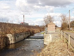 Wraysbury River, flow gauging station, and M25
 -
 Outlet of Wraysbury River and River Colne


References
See also
| Rivers |
|
|---|---|
| Non-tributaries | |
|---|---|
| Tributaries | |
| Passing Denham/Iver |
|
| Man-made | |
51°26′02″N 0°30′50″W / 51.434°N 0.514°W
This Berkshire location article is a stub. You can help Wikipedia by expanding it. |
This Buckinghamshire location article is a stub. You can help Wikipedia by expanding it. |