
Wupatki National Monument
This article needs attention from an expert in Indigenous peoples of North America. See the talk page for details. (January 2013) |
| Wupatki National Monument | |
|---|---|
IUCN category V (protected landscape/seascape) | |
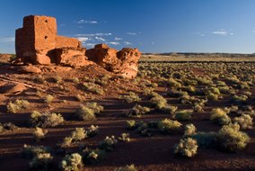 Wukoki in 2008 | |
  | |
| Location | Coconino County, Arizona, US |
| Nearest city | Flagstaff, Arizona |
| Coordinates | 35°33′27″N 111°23′45″W / 35.55750°N 111.39583°W |
| Area | 35,422 acres (143.35 km2)[1] |
| Created | December 9, 1924[2] |
| Visitors | 205,122 (in 2018)[3] |
| Governing body | National Park Service |
| Website | Wupatki National Monument |
The Wupatki National Monument is a
History
The many settlement sites scattered throughout the monument were built by the


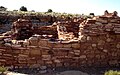
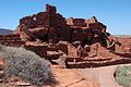
The dwelling's walls were constructed from thin, flat blocks of the local Moenkopi sandstone, giving the pueblos their distinct red color. Held together with mortar, many of the walls still stand. Each settlement was constructed as a single building, sometimes with scores of rooms. The largest settlement on monument territory is the Wupatki Pueblo, built around a natural rock outcrop. With more than 100 rooms, this pueblo is believed to be the region's tallest and largest structure for its time period. The monument also contains structures identified as a ball court, similar to those found in Mesoamerica and in the Hohokam sites of southern Arizona; this is the northernmost example of this kind of structure. This site also contains a geological blowhole,[9] from which wind escapes from a cave system. Other major sites are Wukoki and The Citadel.
Today, Wupatki appears empty and abandoned, but it is remembered and cared for. Although it is no longer physically occupied, Hopi believe the people who lived and died here remain as spiritual guardians. Stories of Wupatki are passed on among Hopi, Navajo, Zuni, and other Native American tribes in the region. Members of the Hopi Bear, Katsina, Lizard, Rattlesnake, Sand, Snow, and Water Clans return periodically to enrich their personal understanding of their clan history.[10]

Amidst what would seem a generally inhospitable area due to the lack of food and water sources, several artifacts have been located at the site from distant locations, implying that the people who inhabited Wupatki were involved in trade. During numerous excavations stretching back to the site' exploration in the mid-1800s,
- Wupatki Sites
-
 Wupatki Paronama
 -
 Wupatki Ball Court
 -
 Box Canyon
 -
 Wupatki Pueblo


Climate
Wupatki has a dry climate, classified by the
Studies have been conducted to compare the climate of Wupatki in the 12th and 13th century, to the 20th century. The findings show that there has been very little change to the climate in the last 2,000 years.[12]
| Climate data for Wupatki National Monument, Arizona, 1991–2020 normals, extremes 1940–present | |||||||||||||
|---|---|---|---|---|---|---|---|---|---|---|---|---|---|
| Month | Jan | Feb | Mar | Apr | May | Jun | Jul | Aug | Sep | Oct | Nov | Dec | Year |
| Record high °F (°C) | 76 (24) |
77 (25) |
85 (29) |
92 (33) |
101 (38) |
107 (42) |
109 (43) |
106 (41) |
102 (39) |
93 (34) |
82 (28) |
72 (22) |
109 (43) |
| Mean maximum °F (°C) | 61.7 (16.5) |
67.7 (19.8) |
76.7 (24.8) |
84.7 (29.3) |
91.5 (33.1) |
101.3 (38.5) |
103.4 (39.7) |
99.7 (37.6) |
94.6 (34.8) |
85.9 (29.9) |
72.7 (22.6) |
62.1 (16.7) |
104.0 (40.0) |
| Mean daily maximum °F (°C) | 47.6 (8.7) |
54.5 (12.5) |
63.1 (17.3) |
70.5 (21.4) |
79.7 (26.5) |
91.5 (33.1) |
94.4 (34.7) |
91.2 (32.9) |
84.6 (29.2) |
72.5 (22.5) |
57.9 (14.4) |
45.9 (7.7) |
71.1 (21.7) |
| Daily mean °F (°C) | 36.8 (2.7) |
42.3 (5.7) |
49.8 (9.9) |
56.7 (13.7) |
65.7 (18.7) |
76.7 (24.8) |
80.8 (27.1) |
78.2 (25.7) |
71.2 (21.8) |
59.0 (15.0) |
45.8 (7.7) |
35.5 (1.9) |
58.2 (14.6) |
| Mean daily minimum °F (°C) | 26.0 (−3.3) |
30.1 (−1.1) |
36.4 (2.4) |
42.9 (6.1) |
51.6 (10.9) |
61.9 (16.6) |
67.1 (19.5) |
65.2 (18.4) |
57.7 (14.3) |
45.6 (7.6) |
33.7 (0.9) |
25.2 (−3.8) |
45.3 (7.4) |
| Mean minimum °F (°C) | 14.8 (−9.6) |
18.4 (−7.6) |
24.5 (−4.2) |
30.7 (−0.7) |
38.1 (3.4) |
49.8 (9.9) |
59.2 (15.1) |
57.8 (14.3) |
46.5 (8.1) |
32.3 (0.2) |
20.7 (−6.3) |
13.3 (−10.4) |
11.5 (−11.4) |
| Record low °F (°C) | −4 (−20) |
−2 (−19) |
10 (−12) |
14 (−10) |
20 (−7) |
30 (−1) |
41 (5) |
35 (2) |
33 (1) |
17 (−8) |
7 (−14) |
−5 (−21) |
−5 (−21) |
| Average precipitation inches (mm) | 0.68 (17) |
0.51 (13) |
0.60 (15) |
0.41 (10) |
0.40 (10) |
0.12 (3.0) |
1.59 (40) |
1.47 (37) |
0.99 (25) |
0.68 (17) |
0.48 (12) |
0.58 (15) |
8.51 (216) |
| Average snowfall inches (cm) | 0.5 (1.3) |
0.9 (2.3) |
0.4 (1.0) |
0.3 (0.76) |
0.0 (0.0) |
0.0 (0.0) |
0.0 (0.0) |
0.0 (0.0) |
0.0 (0.0) |
0.0 (0.0) |
0.4 (1.0) |
0.9 (2.3) |
3.4 (8.6) |
| Average precipitation days (≥ 0.01 inch) | 3.5 | 3.6 | 3.6 | 2.7 | 3.0 | 1.2 | 7.1 | 9.0 | 5.4 | 3.8 | 2.8 | 3.7 | 49.4 |
| Average snowy days (≥ 0.1 inch) | 0.7 | 0.6 | 0.2 | 0.2 | 0.0 | 0.0 | 0.0 | 0.0 | 0.0 | 0.0 | 0.2 | 0.7 | 2.6 |
| Source: NOAA[13][14] | |||||||||||||
See also
References
- ^ "Listing of acreage – December 31, 2011" (XLSX). Land Resource Division, National Park Service. Retrieved May 14, 2012. (National Park Service Acreage Reports)
- ^ . December 9, 1924 – via Wikisource.
- ^ "NPS Annual Recreation Visits Report". National Park Service. Retrieved April 11, 2019.
- ^ "History & Culture". Wupatki National Monument Arizona. National Park Service. January 4, 2018. Retrieved June 6, 2022.
- ^ "National Register Information System". National Register of Historic Places. National Park Service. March 13, 2009.
- ^ Catherine M. Cameron and Cherie L. Schieck (July 28, 1992). "National Register of Historic Places Registration: Wupatki National Monument".
- ISBN 978-0136156864.
- ISSN 0278-4165.
- ^ "The Breathing Earth: Wupatki Blowholes" (PDF). nps.gov. National Park Service U.S. Department of the Interior. Archived from the original (PDF) on October 29, 2015. Retrieved May 8, 2015.
- ^ "National Park Service". Wupatki National Monument. National Park Service. November 6, 2010.
- ^ "Welcome to Anthropology Labs". jan.ucc.nau.edu. Retrieved April 8, 2012.
- ISSN 0190-0528.
- ^ "NOWData - NOAA Online Weather Data". National Oceanic and Atmospheric Administration. Retrieved December 12, 2022.
- ^ "Summary of Monthly Normals 1991-2020". National Oceanic and Atmospheric Administration. Retrieved December 12, 2022.
External links
 Geographic data related to Wupatki National Monument at OpenStreetMap
- NPS: official Wupatki National Monument website
- American Southwest, National Park Service Discover Our Shared Heritage Travel Itinerary
- Anthropology Laboratories of Northern Arizona University
- U.S. Geological Survey Geographic Names Information System: Wupatki National Monument
- Historic American Buildings Survey (HABS) No. AZ-152-A, "Wupatki, Wupatki Ruin, U.S. Highway 89, Loop Road, Flagstaff vicinity, Coconino County, AZ"
- HABS No. AZ-152-B, "Wupatki, Wukoki Ruin, U.S. Highway 89, Loop Road, Flagstaff vicinity, Coconino County, AZ"
- HABS No. AZ-152-C, "Wupatki, Citadel Ruin, U.S. Highway 89, Loop Road, Flagstaff vicinity, Coconino County, AZ"
- HABS No. AZ-152-D, "Wupatki, Ball Court, U.S. Highway 89, Loop Road, Flagstaff vicinity, Coconino County, AZ"