
Yalu River
| Yalu Amnok | |
|---|---|
North Pyongan (DPRK), Sinuiju SAR (DPRK) | |
| Physical characteristics | |
| Source | South of Heaven Lake, PRC-DPRK border, Paektu Mountain |
| • coordinates | 41°58′8″N 128°4′24″E / 41.96889°N 128.07333°E |
| Mouth | Korea Bay |
• coordinates | 39°52′N 124°19′E / 39.867°N 124.317°E |
| Length | 790 km (490 mi) |
| Yalu River | |
|---|---|
| Chinese name | |
Hanyu Pinyin | Yālù Jiāng |
| Wade–Giles | Ya1-lu4 Chiang1 |
| IPA | [jálû tɕjáŋ] |
| Wu | |
| Romanization | Ah平 loe去 kaon平 |
| Yue: Cantonese | |
| Jyutping | Aap3luk6 Gong1 |
| IPA | [ʔáːplʊ̀kkɔ́ːŋ] |
| Transcriptions | |
|---|---|
| Revised Romanization | Amnokgang |
| McCune–Reischauer | Amnokkang |
ᡠᠯᠠ
The Yalu River (Chinese: 鸭绿江; pinyin: Yālù Jiāng) or Amnok River (Korean: 압록강; MR: Amnokkang) is a river on the border between China and North Korea. Together with the Tumen River to its east, and a small portion of Paektu Mountain, the Yalu forms the border between China and North Korea. Its valley became the scene of several military conflicts in the past centuries. It borders North Korea to the south, borders Russia to the northeast and borders China to the north.
Name
The Korean name Amrok (압록; 鴨綠) is most likely derived from ancient Koreanic language of
It is also known by the name of Arinarye (아리나례강, 阿利那禮江). Ari, a word from Old Korean used to refer to the 'spirituality (신령성; 神靈性) of the sun'.[1] The second component might be related to the Old Korean word for 'river, stream', nari (나리, 川理).
There are two theories regarding the origin of Yalu river name. One theory is that the name derived from Yalu ula (ᠶᠠᠯᡠ
ᡠᠯᠠ) in the Manchu language. The Manchu word yalu (ᠶᠠᠯᡠ) means "the boundary between two countries". In Mandarin Chinese, yālù phonetically approximates the original Manchu word, but literally means "duck green", which was said to have been once the color of the river. The other theory is that the river was named after the combination of its two upper branches, which were called "鴨" (Yā or Ap) and "綠" (Lù or R(or n)ok)", respectively.
Revised Romanization of Korean spelled it Amnokgang (Korean pronunciation: [amnok.k͈aŋ]; "Amnok River") and Revised Romanization of Hangeul spelled it Aprokgang (Korean pronunciation: [amnok.k͈aŋ]; "Aprok River").
Geography
From 2,500 metres (8200') above sea level on
The river is 795 kilometers (494 mi) long and receives water from over 30,000 km2 (10,000 sq. mi.) of land. The Yalu's most significant
The depth of the Yalu River varies from some of the more shallow parts on the eastern side in Hyesan (1 meter (3 ft 3 in)) to the deeper parts of the river near the Yellow Sea (2.5 meters (8 ft 2 in)).[4] The estuary is the site of the Amrok River estuary Important Bird Area, identified as such by BirdLife International.[5]
About 205 islands are on the Yalu. A 1962
History

The river basin is the site where the ancient Korean kingdom of Goguryeo rose to power. Many former fortresses are located along the river and the former capital of that kingdom was situated at what is now the medium-sized city of Ji'an along the Yalu, a site rich in Goguryeo era relics.[6] Wihwa Island on the river is historically famous as the place where, in 1388, General Yi Songgye (later Taejo of Joseon) decided to turn back his army southward to Kaesong in the first of a series of revolts that eventually led to the establishment of the Joseon dynasty.[7]
The river has been the site of several battles because of its strategic location between Korea and China, including:
- Battle of the Yalu River (1894) – First Sino-Japanese War
- Battle of Yalu River (1904) – Russo-Japanese War
- Battle near to the Yalu River (1950) – Korean War
The southern side of the river was heavily industrialized during the period of Japanese rule (1910–1945), and by 1945 almost 20% of Japan's total industrial output originated in Korea.
During the Korean War, the movement of United Nations troops approaching the river, despite repeated warnings by China not to, precipitated massive Chinese intervention from around Dandong. In the course of the conflict every bridge across the river except one was destroyed. The one remaining bridge was the Sino-Korean Friendship Bridge connecting Sinuiju, North Korea to Dandong, China. During the war the valley surrounding the western end of the river also became the focal point of a series of dogfights for air supremacy over North Korea, earning the nickname "MiG Alley" in reference to the MiG-15 fighters flown by the combined North Korean, Chinese, and Soviet forces.[8] As UN forces during the Korean War advanced toward the Yalu, China under Chairman Mao Zedong entered the war on the side of North Korea.[9]
The river has frequently been crossed by North Koreans fleeing to China since the early 1990s, although the Tumen River remains the most-used way for such refugees.[10]
According to one scholar, the Korean-Chinese border along the Yalu River is the longest unchanged international border in history, lasting for at least 1,000 years.[11][12][13]
-
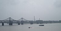
 The pillar stubs of the Yalu River Broken Bridge between Dandong and Sinuiju, which was established in 1911 and destroyed during the Korean War. The bridge to the left is the Sino-Korean Friendship Bridge, which opened to traffic in 1943 and also fell to destruction by US aerial attacks during the war but was successfully repaired after 1953 (direction of photo looking south into North Korea).
 -


Economy

The river is important for hydroelectric power, and one of the largest hydroelectric dams in Asia is in Sup'ung Dam, 106 metres (348') high and over 850 metres (2800') long, located upstream from Sinuiju, North Korea. The dam has created an artificial lake over a portion of the river, called Supung Lake. In addition, the river is used for transportation, particularly of lumber from its forested banks. The river provides fish for the local population. Downstream of Sup'ung is the Taipingwan Dam. Upstream of Sup'ung is the Unbong Dam. Both dams produce hydroelectric power, as well.
In the river delta upstream from Dandong and adjacent to Hushan are several North Korean villages. Economic conditions in these villages have been described as poor, without access to electricity.[14]
Crossings
- Ji'an Yalu River Border Railway Bridge, Ji'an China – Manp'o, North Korea
- New Yalu River Bridge, under construction between Dandong, China and Sinŭiju, North Korea
- Sino-Korean Friendship Bridge, Dandong, China – Sinŭiju, North Korea
See also
- Sino-Korean Friendship Bridge
- China–North Korea relations
- Geography of China
- Geography of North Korea
References
- ^ "압록강(鴨綠江)". Encyclopedia of Korean Culture (in Korean). Retrieved 2024-01-23.
- ^ "Sediments in Korea Bay and Incheon Bay, North and South Korea". www.eosnap.com. March 25, 2011. Archived from the original on January 5, 2012. Retrieved July 6, 2021.
- ^ "A trip to the North Korea-China border, in photos". NK News. 29 May 2015.
- ^ "Yalu River | river, Asia". Encyclopedia Britannica. Retrieved 2021-07-06.
- ^ "Amrok River estuary". Important Bird Areas factsheet. BirdLife International. 2013. Retrieved 2013-04-25.
- ^ Centre, UNESCO World Heritage. "Capital Cities and Tombs of the Ancient Koguryo Kingdom". UNESCO World Heritage Centre.
- ^ Jeong Woo-sang (10 June 2011). "What Is Hwanggumpyong Island?". Digital Chosun. Retrieved 1 March 2012.
- )
- )
- ^ "What North Korean Defectors Think Of North Korea | STAY CURIOUS #1". Archived from the original on 2021-12-11 – via www.youtube.com.
- ^ "Oldest border in the world". koreatimes. Apr 5, 2020.
- ^ "외국인 할아버지가 한국인에게 경복궁 투어를?! 첫번째 밋업! ( Dr. Peterson's First Meet-up! Palace Tour)". Archived from the original on 2021-12-11 – via www.youtube.com.
- ^ "하버드 한국학자가 말하는 한국은 평화로운 역사를 가진 나라?! 소개편 Peaceful Korea – Introduction". Archived from the original on 2021-12-11 – via www.youtube.com.
- ^ "We took a boatride on the Yalu River across the Sino-Korean Border. Here's what we saw". visitthedprk.org. 27 November 2017. Archived from the original on 13 November 2020. Retrieved 10 January 2018.
External links
- Encyclopædia Britannica
- . New International Encyclopedia. 1905.