
Yangtze
| Yangtze River 长江 | |
|---|---|
| Autonomous region | Tibet |
| Cities | Luzhou, Chongqing, Yichang, Jingzhou, Yueyang, Wuhan, Jiujiang, Anqing, Tongling, Wuhu, Nanjing, Zhenjiang, Yangzhou, Nantong, Shanghai |
| Physical characteristics | |
| Source | Dam Qu (Jari Hill) |
| • location | Tanggula Mountains, Qinghai |
| • coordinates | 32°36′14″N 94°30′44″E / 32.60389°N 94.51222°E |
| • elevation | 5,170 m (16,960 ft) |
| 2nd source | Ulan Moron |
| • coordinates | 33°23′40″N 90°53′46″E / 33.39444°N 90.89611°E |
| 3rd source | Chuma'er River |
| • coordinates | 35°27′19″N 90°55′50″E / 35.45528°N 90.93056°E |
| 4th source | Muluwusu River |
| • coordinates | 33°22′13″N 91°10′29″E / 33.37028°N 91.17472°E |
| 5th source | Bi Qu |
| • coordinates | 33°16′58″N 91°23′29″E / 33.28278°N 91.39139°E |
| Mouth | East China Sea |
• location | Shanghai and Jiangsu |
• coordinates | 31°23′37″N 121°58′59″E / 31.39361°N 121.98306°E |
| Length | 6,300 km (3,900 mi)[1] |
| Basin size | 1,808,500 km2 (698,300 sq mi)[2] |
| Discharge | |
| • average | 30,146 m3/s (1,064,600 cu ft/s)[3] |
| • minimum | 2,000 m3/s (71,000 cu ft/s) |
| • maximum | 110,000 m3/s (3,900,000 cu ft/s)[4][5] |
| Discharge | |
| • location | Datong hydrometric station, Anhui (Uppermost boundary of the ocean tide) |
| • average | (Period: 1980–2020)905.7 km3/a (28,700 m3/s)[6] 30,708 m3/s (1,084,400 cu ft/s) (2019–2020)[7] |
| Discharge | |
| • location | Wuhan (Hankou) |
| • average | (Period: 1980–2020)711.1 km3/a (22,530 m3/s)[6] |
| Discharge | |
| • location | Yichang (Three Gorges Dam) |
| • average | (Period: 1980–2020)428.7 km3/a (13,580 m3/s)[6] |
| Basin features | |
| Tributaries | |
| • left | Gan, Huangpu |
| Chang Jiang | |||||||
|---|---|---|---|---|---|---|---|
Tibetan འབྲི་ཆུ་ | | ||||||
| |||||||
Yangtze or Yangzi (English:
The Yangtze has played a major role in the
The Yangtze flows through a wide array of ecosystems and is habitat to several
Etymology
Chinese
Cháng Jiāng (长江; 長江) or "Long River" is the official name for the Yangtze in
In
By the Han dynasty, Jiāng had come to mean any river in Chinese, and this river was distinguished as the "Great River" 大江 (Dàjiāng). The epithet 長 (simplified version 长), meaning "long", was first formally applied to the river during the Six Dynasties period.[citation needed]
Various sections of the Yangtze have local names. From Yibin to
English
The river was called Quian (江) and Quianshui (江水) by
The name Blue River began to be applied in the 18th century,[22] apparently owing to a former name of the Dam Chu[28] or Min[30] and to analogy with the Yellow River,[31][32] but it was frequently explained in early English references as a 'translation' of Jiang,[33][34] Jiangkou,[24] or Yangzijiang.[35] Very common in 18th- and 19th-century sources, the name fell out of favor due to growing awareness of its lack of any connection to the river's Chinese names[36][37] and to the irony of its application to such a muddy waterway.[37][38]
By 1800, English cartographers such as
Tibetan
The source and upper reaches of the Yangtze are located in
: Zhíqū).Geography

The river originates from several tributaries in the eastern part of the
These tributaries join and the river then runs eastward through Qinghai (Tsinghai), turning southward down a deep valley at the border of Sichuan (Szechwan) and Tibet to reach Yunnan. In the course of this valley, the river's elevation drops from above 5,000 m (16,000 ft) to less than 1,000 m (3,300 ft). Thus, over the first 2,600 km (1,600 mi) of its length, the river has fallen more than 5,200 m (17,000 ft).[46]
It enters the basin of Sichuan at
After entering Hubei province, the Yangtze receives water from a number of lakes. The largest of these lakes is
At the northern tip of Jiangxi province,
Four of China's five main freshwater lakes contribute their waters to the Yangtze River. Traditionally, the upstream part of the Yangtze River refers to the section from Yibin to Yichang; the middle part refers to the section from Yichang to
The origin of the Yangtze River has been dated by some geologists to about 45 million years ago in the Eocene,[47] but this dating has been disputed.[48][49]
Image gallery
-
 The glaciers of the Tanggula Mountains, the traditional source of the Yangtze River
 -
 TheTuotuo River, a headwater stream of the Yangtze River, known in Tibetan as Maqu, or the "Red River"
 -
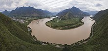 The first turn of the Yangtze at Shigu (石鼓) in Yunnan, where the river turns 180 degrees from southbound to northbound
 -
 Tiger Leaping Gorge in Yunnan
 -
 Narrowest point of theLijiang, downstream from Shigu
 -
 The Jinsha, "Golden Sands River", in Yunnan
 -
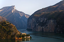 Qutang Gorge, one of the Three Gorges
 -
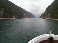 Wu Gorge, one of the Three Gorges
 -
 Xiling Gorge, one of the Three Gorges
 -

-
![Golden Island on the Yangtze near Zhenjiang in Jiangsu, as it was in the mid-19th century[50]](//upload.wikimedia.org/wikipedia/commons/thumb/3/34/Golden_Island%2C_on_The_Yang-Tse_River%2C_China_%28LMS%2C_1869%2C_p.64%29.jpg/221px-Golden_Island%2C_on_The_Yang-Tse_River%2C_China_%28LMS%2C_1869%2C_p.64%29.jpg)


![Golden Island on the Yangtze near Zhenjiang in Jiangsu, as it was in the mid-19th century[50]](/File:Golden_Island,_on_The_Yang-Tse_River,_China_(LMS,_1869,_p.64).jpg)
History
Geologic history
Although the mouth of the

Early history
The Yangtze River is important to the cultural origins of
The Central Yangtze valley was home to sophisticated Neolithic cultures.[57] Later it became the earliest part of the Yangtze valley to be integrated into the North Chinese cultural sphere. (Northern Chinese were active there since the Bronze Age).[58]

In the lower Yangtze, two
Whether native or nativizing, the Yangtze states held their own against the northern Chinese homeland: some lists credit them with three of the
The state of Qin conquered the central Yangtze region, previous heartland of Chu, in 278 BC, and incorporated the region into its expanding empire. Qin then used its connections along the Yangtze River the
Since the
The Yangtze has long been the backbone of China's inland water transportation system, which remained particularly important for almost two thousand years, until the construction of the national railway network during the 20th century. The
Historically, the Yangtze became the political boundary between north China and south China several times (see
The Yangtze was the site of naval battles between the
Politically,

Age of steam
The Jardine, the first steamship to sail the river, was built for
The China Navigation Company was an early shipping company founded in 1876 in London, initially to trade up the Yangtze River from their Shanghai base with passengers and cargo. Chinese coastal trade started shortly after, and in 1883 a regular service to Australia was initiated.[65]
_docked_in_China,_in_the_1930s.jpg)


Steamers came late to the upper river, the section stretching from Yichang to Chongqing. Freshets from Himalayan snowmelt created treacherous seasonal currents. But summer was better navigationally and the
Standard Oil ran the tankers Mei Ping, Mei An and Mei Hsia, which were collectively destroyed on December 12, 1937, when Japanese warplanes bombed and sank the U.S.S. Panay. One of the Standard Oil captains who survived this attack had served on the Upper River for 14 years.[73]

Contemporary events
Chinese Communist Party chairman Mao Zedong took staged swims in the river in 1956 and 1966 at Wuhan in publicity stunts to demonstrate his health, also starting a swimming craze through party propaganda.[74][75]
In 2002, Danish adventurer and sailor Troels Kløvedal sailed up the Yangtze, from Shanghai to past the Three Gorges Dam, in the collectively owned "Nordkaperen" sailing ship. Kløvedal had spent 12 years preparing and gathering the required permissions, and with a crew of Danes, his family members, a Chinese interpreter and several local maritime pilots, he became the first foreigner since 1949 to navigate the Yangtze.[76] His months-long journey was documented both in his 2004 book "Kineserne syr med lang tråd" and the TV show "Kløvedal i Kina" by DR.[77]
In August 2019, Welsh adventurer Ash Dykes became the first person to complete the 4,000-mile (6,437 km) trek along the course of the river, walking for 352 days from its source to its mouth.[78]
Hydrology
Periodic floods
Tens of millions of people live in the floodplain of the Yangtze valley, an area that naturally floods every summer and is habitable only because it is protected by river dikes. The floods large enough to overflow the dikes have caused great distress to those who live and farm there. Floods of note include those of 1931, 1954, and 1998.
The 1931 Central China floods or the Central China floods of 1931 were a series of floods that are generally considered among the deadliest natural disasters ever recorded, and almost certainly the deadliest of the 20th century (when pandemics and famines are discounted). Estimates of the total death toll range from 145,000 to between 3.7 million and 4 million.[79][80] The Yangtze flooded again in 1935, causing great loss of life.
From June to September 1954, the
The
The 2016 China floods caused US$22 billion in damages.
In 2020, the Yangtze river saw the heaviest rainfall since 1961, with a 79% increase in June and July compared to the average for the period over the previous 41 years. A new theory suggested that abrupt reduction in emissions of greenhouse gases and aerosols, caused by shutdowns during the COVID-19 pandemic, was a key cause of the intense downpours. Over the past decades rainfall had decreased due to increase of aerosols in the atmosphere, and lower greenhouse gas emissions in 2020 caused the opposite effect – a major increase in rain. Such a dramatic reduction of aerosols caused a dramatic change in the various components of the climate system, but such sudden change of the climate system would be very different from changes in response to continuous but gradual policy-driven emissions reductions.[84]
Degradation of the river

Beginning in the 1950s, dams and dikes were built for flood control, land reclamation, irrigation, and control of diseases vectors such as
In 2020, a sweeping law was passed by the Chinese government to protect the ecology of the river. The new laws include strengthening ecological protection rules for hydropower projects along the river, banning chemical plants within 1 kilometer of the river, relocating polluting industries, severely restricting sand mining as well as a complete fishing ban on all the natural waterways of the river, including all its major tributaries and lakes.[90]
Contribution to ocean pollution
The Yangtze River produces more ocean plastic pollution than any other, according to The Ocean Cleanup, a Dutch environmental research foundation that focuses on ocean pollution. 10 Rivers transport 90% of all the plastic that reaches the oceans, the Yangtze river being the biggest polluter by far.[91][92]
Reconnecting lakes
In 2002 a pilot program was initiated to reconnect lakes to the Yangtze with the objective to increase biodiversity and to alleviate flooding. The first lakes to be reconnected in 2004 were
Reconnecting the lakes improved water quality and fish were able to migrate from the river into the lake, replenishing their numbers and genetic stock. The trial also showed that reconnecting the lake reduced flooding. The new approach also benefitted the farmers economically. Pond farmers switched to natural fish feed, which helped them breed better-quality fish that can be sold for more, increasing their income by 30%. Based on the successful pilot project, other provincial governments emulated the experience and also reestablished connections to lakes that had previously been cut off from the river. In 2005 a Yangtze Forum has been established bringing together 13 riparian provincial governments to manage the river from source to sea.[93] In 2006 China's Ministry of Agriculture made it a national policy to reconnect the Yangtze River with its lakes. As of 2010, provincial governments in five provinces and Shanghai set up a network of 40 effective protected areas, covering 16,500 km2 (6,400 sq mi). As a result, populations of 47 threatened species increased, including the critically endangered Yangtze alligator. In the Shanghai area, reestablished wetlands now protect drinking water sources for the city. It is envisaged to extend the network throughout the entire Yangtze to eventually cover 102 areas and 185,000 km2 (71,000 sq mi). The mayor of Wuhan announced that six huge, stagnating urban lakes including the East Lake (Wuhan) would be reconnected at the cost of US$2.3 billion creating China's largest urban wetland landscape.[85][94]
Major cities along the river

Crossings
Until 1957, there were no bridges across the Yangtze River from Yibin to Shanghai. For millennia, travelers crossed the river by ferry. On occasions, the crossing may have been dangerous, as evidenced by the Zhong'anlun disaster (October 15, 1945).
The river stood as a major geographic barrier dividing northern and southern China. In the first half of the 20th century, rail passengers from Beijing to Guangzhou and Shanghai had to disembark, respectively, at
After the founding of the People's Republic in 1949, Soviet engineers assisted in the design and construction of the
Bridge-building slowed in the 1980s before resuming in the 1990s and accelerating in the first decade of the 21st century. The
A number of power line crossings have also been built across the river.
-
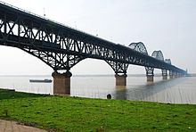
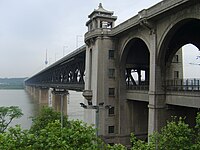 Wuhan Yangtze River Bridge, the first bridge crossing Yangtze, was completed in 1957.
 -
 The Nanjing Yangtze River Bridge, a beam bridge, was completed in 1968.
 -
 The Jiujiang Yangtze River Bridge, an arch bridge, was completed in 1992.
 -
 TheYichang Yangtze Highway Bridge, a suspension bridgenear the Gezhouba Dam lock, was completed in 1996.
 -
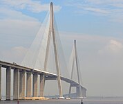 Thecable-stayed bridgesin the world when it was completed in 2008.
 -
 The Caiyuanba Bridge, an arch bridge in Chongqing, was completed in 2007.
 -
 The cable-stayed Anqing Yangtze River Bridge at Anqing, was completed in 2005.
 -
 Wuhan Metro Line 2 is the first underground rail line crossing the Yangtze River.


Dams


As of 2007, there are two dams built on the Yangtze river: Three Gorges Dam and Gezhouba Dam. The Three Gorges Dam is the largest power station in the world by installed capacity, at 22.5 GW. Several dams are operating or are being constructed on the upper portion of the river, the Jinsha River. Among them, the Baihetan Dam is the second largest after the Three Gorges Dam, and the Xiluodu Dam is the 4th largest power station in the world.
Tributaries

The Yangtze River has over 700 tributaries. The major tributaries (listed from upstream to downstream) with the locations of where they join the Yangtze are:
- Yalong River (Panzhihua, Sichuan)
- Min River (Yibin, Sichuan)
- Tuo River (Luzhou, Sichuan)
- Chishui River (Hejiang, Sichuan)
- Jialing River (Chongqing)
- Fuling, Chongqing)
- Yidu, Hubei)
- Yuan River (via Dongting Lake)
- Lishui River (via Dongting Lake)
- Zi River (via Dongting Lake)
- Xiang River (Yueyang, Hunan)
- Han River (Wuhan, Hubei)
- Gan River (near Jiujiang, Jiangxi)
- Dangtu, Anhui)
- Qingyi River (Wuhu, Anhui)
- Chao Lake water system (Chaohu, Anhui)
- Lake Tai water system (Shanghai)
The Huai River flowed into the Yellow Sea until the 20th century, but now primarily discharges into the Yangtze.
-
 Gan River in Jiangxi
 -
 Han Riverin Hubei
 -

-
 Wu Riverin Guizhou
 -

-
 Min River in central Sichuan
 -
 Yalong River in western Sichuan


Protected areas
- Sanjiangyuan ("Three Rivers' Sources") National Nature Reservein Qinghai
- Three Parallel Rivers of Yunnan
Wildlife
The Yangtze River has a high species richness, including many endemics. A high percentage of these are seriously threatened by human activities.[95]
Fish

As of 2011[update], 416 fish species are known from the Yangtze
Many Yangtze fish species have declined drastically and 65 were recognized as

The largest threats to the Yangtze native fish are
While many fish species native to the Yangtze are seriously threatened, others have become important in
Other animals

Due to commercial use of the river, tourism, and pollution, the Yangtze is home to several seriously threatened species of large animals (in addition to fish): the
Numerous species of land mammals are found in the Yangtze valley, but most of these are not directly associated with the river. Three exceptions are the semi-aquatic Eurasian otter, water deer and Père David's deer.[117]

In addition to the very large and exceptionally rare Yangtze giant softshell turtle, several smaller turtle species are found in the Yangtze basin, its
More than 160

The Yangtze basin contains a large number of freshwater crab species, including several endemics.[127] A particularly rich genus in the river basin is the potamid Sinopotamon.[128] The Chinese mitten crab is catadromous (migrates between fresh and saltwater) and it has been recorded up to 1,400 km (870 mi) up the Yangtze, which is the largest river in its native range.[126] It is a commercially important species in its native range where it is farmed,[125] but the Chinese mitten crab has also been spread to Europe and North America where considered invasive.[126]
The freshwater jellyfish Craspedacusta sowerbii, now an invasive species in large parts of the world, originates from the Yangtze.[129]
Tourism
The Yangtze River cruise, also called the "Three Gorges cruise", is a popular tourist attraction.[citation needed]
See also
- Category: Tributaries of the Yangtze River
- List of rivers in China
- Northern and Southern China, traditionally divided by the Huai Riverbut sometimes considered to separate at the Yangtze
- Rediscovering the Yangtze River
- Ship lifts in China
- South-North Water Transfer Project
- Steamboats on the Yangtze River
- Yangtze River Crossing
- Yangtze Service Medal
Notes
- ^ The Chinese name is simplified Chinese: 长江; traditional Chinese: 長江; pinyin: Cháng Jiāng; lit. 'long river' – see § Etymology.
References
- ^ Encyclopædia Britannica: Yangtze River. Archived August 21, 2008, at the Wayback Machine.
- S2CID 122626377.
- ^ "Main Rivers". National Conditions. China.org.cn. Archived from the original on March 13, 2012. Retrieved July 27, 2010.
- ^ https://probeinternational.org/three-gorges-probe/flood-types-yangtze-river Archived July 23, 2011, at the Wayback Machine Accessed February 1, 2011
- ^ "Three Gorges Says Yangtze River Flow Surpasses 1998". Bloomberg Businessweek. July 20, 2010. Archived from the original on July 23, 2010. Retrieved July 27, 2010.
- ^ .
- .
- ^ "Yangtze River". Britannica. Retrieved May 8, 2023.
- ^ quote="Today, the Yangtze region is home to more than 400 million people, or nearly one-third of China's population. Some of China's largest cities" Archived December 13, 2017, at the Wayback Machine [1][permanent dead link]. Retrieved September 10, 2010. (in Chinese)
- ^ "Three Gorges Dam, China: Image of the Day". earthobservatory.nasa.gov. June 8, 2009. Archived from the original on October 16, 2009. Retrieved November 3, 2009.
- ^ International Rivers, Three Gorges Dam profile Archived April 20, 2009, at the Wayback Machine. Retrieved August 3, 2009
- ^ "New stimulus measures by China to boost economic growth". Beijing Bulletin. Archived from the original on July 14, 2014. Retrieved June 12, 2014.
- ^ "90 percent of ocean plastic waste comes from Asia and Africa • Earth.com". Earth.com. Archived from the original on January 9, 2019. Retrieved January 9, 2019.
- ^ a b George, Jamieson (1911). . In Chisholm, Hugh (ed.). Encyclopædia Britannica. Vol. 28 (11th ed.). Cambridge University Press. p. 903.
- ^ Yule, Henry. The River of Golden Sand: The Narrative of a Journey Through China and Eastern Tibet to Burmah, Vol. 1, p. 35 Archived May 11, 2016, at the Wayback Machine. "Introductory Essay." 1880. Reprint: Cambridge University Press, 2010. Retrieved August 14, 2013.
- ^ a b Baxter, Wm. H. & Sagart, Laurent. "Baxter–Sagart Old Chinese Reconstruction". Archived from the original on April 25, 2012. (1.93 MB), p. 56. 2011. Retrieved August 12, 2013.
- ^ Baxter & al. (2011), "p. 69". Archived from the original on April 25, 2012. (1.93 MB).
- ^ Philipsen, Philip. Sound Business: The Reality of Chinese Characters, p. 12 Archived April 27, 2016, at the Wayback Machine. iUniverse (Lincoln), 2005. Retrieved August 12, 2013.
- ^ An, Min (安民) (January 23, 2010). 《夜晤扬子津》 [Yangtze Ferry]. yznews.com.cn (in Simplified Chinese).[permanent dead link]
- ^ Zhang, Yongqiang (2001). "Effects of the Three Gorges Project on Runoff and Related Benefits of the Key Regions along Main Branches of the Yangtze River". Water. 11 (2019): 269. Retrieved July 8, 2020.
- ^ Pelliot, Paul. Notes on Marco Polo, Vol. 2, p. 818 Archived November 13, 2013, at the Wayback Machine. L'Académie des Inscriptions e Belles-Lettres e avec le Concours du Centre national de la Recherche scientifique (Paris), 1959–1973. Retrieved August 13, 2013.
- ^ a b E.g., Moll, Herman. "The Empire of China and island of Japan, agreeable to modern history. Archived November 13, 2013, at the Wayback Machine" Bowles & Bowles (London), 1736. Retrieved August 13, 2013.
- ^ Encyclopædia Britannica, 3rd ed. "Kiam Archived May 8, 2016, at the Wayback Machine." Bell & Macfarquhar (Edinburgh), 1797. Retrieved August 14, 2013.
- ^ a b Bell, James. A System of Geography, Popular and Scientific; or a Physical, Political, and Statistical Account of the World and its Various Divisions, Vol. V, Part I, p. 215 Archived May 6, 2016, at the Wayback Machine. "Chinese Tartary." A. Fullarton & Co. (London), 1849. Retrieved August 13, 2013.
- ^ Tanner, B. "China divided into its Great Provinces According to the best Authorities Archived November 13, 2013, at the Wayback Machine." Mathew Carey (Philadelphia), 1795. Retrieved August 13, 2013.
- ^ a b Bridgman, Elijah (ed.) The Chinese Repository, Vol. I, pp. 37 ff Archived June 10, 2016, at the Wayback Machine. "Review. Ta Tsing Wan-neën Yih-tung King-wei Yu-too,–'A General Geographical Map, with Degrees of Latitude and Longitude, of the Empire of the Ta Tsing Dynasty–May It Last Forever', by Le Mingche Tsinglae." Canton Mission Press (Guangdong), 1833.
- ^ Konstam, Angus. Yangtze River Gunboats 1900–49, p. 17 Archived May 12, 2016, at the Wayback Machine. Osprey Publishing (Oxford), 2012. Retrieved August 13, 2013.
- ^ Mongolian: Xөх Мөрөн, Höh or Kök Mörön.[27]
- ^ Davenport, Arthur. Report upon the Trading Capabilities of the Country Traversed by the Yunnan Mission, pp. 10 ff Archived April 29, 2016, at the Wayback Machine. Harrison & Sons (London), 1877.
- ^ Recorded as bearing the local Chinese name of 清水 (Qīngshuǐ), literally meaning "Clear Water[way]."[29]
- ^ Aloian, Molly. Rivers Around the World: The Yangtze: China's Majestic River, p. 6 Archived May 4, 2016, at the Wayback Machine. Crabtree Publishing Co. (New York), 2010. Retrieved August 13, 2013.
- ^ Room, Adrian. Placenames of the World, p. 395 Archived May 4, 2016, at the Wayback Machine. 1997. Reprint: McFarland (Jefferson, N.C.), 2003. Retrieved August 13, 2013.
- ^ The Modern Part of an Universal History, from the Earliest Accounts to the Present Time, Vol. XXXVII, p. 57 Archived June 17, 2016, at the Wayback Machine. "Of the Empires of China and Japan." (London), 1783.
- ^ Wilkes, John. Encyclopaedia Londinensis, or, Universal Dictionary of Arts, Sciences, and Literature, Vol. XI, p. 851 Archived April 29, 2016, at the Wayback Machine. "Koko Nor." J. Adlard (London), 1812.
- ^ Liber, Nadine. Life. "A Scary Pageant in Peking", p. 60. September 4, 1964. Retrieved August 14, 2013. Archived April 28, 2016, at the Wayback Machine.
- ^ a b Davis, John. The Chinese: A General Description of the Empire of China and Its Inhabitants, Vol. 1, pp. 132 ff Archived June 23, 2016, at the Wayback Machine. C. Knight, 1836.
- ^ a b The St. James's Magazine, Vol. XIV, p. 230 Archived April 24, 2016, at the Wayback Machine. "A Cruise on the Yangtze Kyang." W. Kent & Co. (London), 1865.
- ^ Moncrieff, A.R.H. The World of To-day: A Survey of the Lands and Peoples of The Globe as Seen in Travel and Commerce, Vol. I, p. 42 Archived May 18, 2016, at the Wayback Machine. Gresham Publishing Co. (London), 1907.
- ^ Ricci, Matteo & al. De Christiana Expeditione Apud Sinas Suscepta ab Societate Jesu, Libri V, 1615. New Edition: De Christiana Expeditione apud Sinas suscepta ab Societate Iesu, Libri V, pp. 365 ff. Archived May 5, 2016, at the Wayback Machine, Bernardus Gualterus (Cologne), 1617. Retrieved August 14, 2013. (in Latin)
- ^ Ricci, Matteo & al. Samuel Purchas (trans.) in Hakluytus Posthumus, or Purchas His Pilgrimes, Vol. XII, p. 305 Archived September 29, 2015, at the Wayback Machine. "A Generall Collection and Historicall representation of the Jesuites entrance into Japon and China, until their admission in the Royall Citie of Nanquin." 1625. Reprint: MacLehose & Co. (Glasgow), 1906. Retrieved August 14, 2013.
- ^ E.g., in Didier, Robert & al. "L'Empire de la Chine Archived October 29, 2013, at the Wayback Machine." Boudet (Paris), 1751. Retrieved August 14, 2013.
- ." G. Allen (London), 1801. Retrieved August 14, 2013.
- ISBN 7-5085-0665-0.
- ^ ISBN 978-0-8050-3888-0.
- ^ Wong How Man (2005) New and longer Yangtze source discovered. Archived October 28, 2010, at the Wayback Machine
- ^ "Yangtze River - The lower course | Britannica". www.britannica.com. Retrieved May 8, 2023.
- (PDF) from the original on July 23, 2018. Retrieved July 11, 2019.
- S2CID 129316271.
- ^ Jietao, Wang. "Geomorphological Evolution of the Hengshixi Anticline of The Three Gorges Area Through Isobases: A Model of Yangtze River Capture" (PDF). International Journal of Simulation: Systems, Science and Technology. 17 (4): 17.1–7. Archived (PDF) from the original on January 30, 2019. Retrieved June 16, 2017.
- ^ London Missionary Society (1869). Fruits of Toil in the London Missionary Society. London: John Snow & Co. p. 64. Archived from the original on March 31, 2019. Retrieved September 12, 2016.
- ^ Métivier, F. & al. "Mass Accumulation Rates in Asia During the Cenozoic Archived March 27, 2019, at the Wayback Machine." Geophysical Journal International, Vol. 137, No. 2, p. 314. 1999. Retrieved December 5, 2013.
- ^ Clift, Peter. "The Marine Geological Record of Neogene Erosional in Asia: Interpreting the Sedimentary Record to Understand Tectonic and Climatic Evolution in the Wake of India-Asia Collision Archived April 18, 2012, at the Wayback Machine." Woods Hole Oceanographic Institution, 2006. Retrieved December 5, 2013.
- ^ "Yayoi linked to Yangtze area". trussel.com. Archived from the original on February 22, 2017. Retrieved March 26, 2017.
- ^ Nature. "Early Homo and associated artifacts from Asia Archived May 21, 2006, at the Wayback Machine."
- ISBN 978-0-87169-865-0.
- ISBN 978-962-201-725-2.
- ^ Zhang Chi (張弛), "The Qujialing-Shijiahe Culture in the Middle Yangzi River Valley," in A Companion to Chinese Archaeology, ed. Anne P. Underhill (Chichester: John Wiley & Sons, 2013), 510–534; Rowan K. Flad and Pochan Chen, Ancient Central China: Centers and Peripheries along the Yangzi River (Cambridge: Cambridge University Press, 2013), 116–25.
- ^ Li Liu and Xingcan Chen, State Formation in Early China (London: Duckworth, 2003), 75–79, 116–26; Li Feng, Landscape and Power in Early China: The Crisis and Fall of the Western Zhou, 1045–771 BC (Cambridge: Cambridge University Press, 2006), 322–32.
- ^ For example, in Sima Qian's Records of the Grand Historian.
- ^ Lothar von Falkenhausen, Chinese Society in the Age of Confucius (1000–250 BC): The Archaeological Evidence (Los Angeles: Cotsen Institute of Archaeology, 2006), 262–88; Constance A. Cook and John S. Major, eds. Defining Chu: Image and Reality in Ancient China (Honolulu: University of Hawaiʻi Press, 1999).
- ^ Brian Lander, "State Management of River Dikes in Early China: New Sources on the Environmental History of the Central Yangzi Region." T'oung Pao 100.4–5 (2014): 325–362.
- ^ Lingqu Canal (Xiang'an County, Guangxi Zhuang Autonomous Region Qin Dynasty) Archived February 28, 2019, at the Wayback Machine (Nomination for the UNESCO Heritage List)
- ISBN 978-962-201-915-7.
- ISBN 978-0-521-30358-3.
- ^ S2CID 144141748. Archived from the original(PDF) on January 9, 2009. Retrieved June 19, 2011.
- (PDF) from the original on September 30, 2011. Retrieved June 19, 2011.
- ^ Lyman P. Van Slyke, Yangtze, Nature, History and the River, Addison-Wesley Publishing Company, Inc., Massachusetts, 1988, p.18-19 and 121–123.
- ^ Ibid., p. 170-172.
- ^ Shih Brandmeyer, Polly (2014). "Cornell Plant, Lost Girls and Recovered Lives – Sino-British Relations at the Human Level in Late Qing and Early Republican China". Journal of the Royal Asiatic Society Hong Kong Branch. 54: 106–110. Archived from the original on August 11, 2018. Retrieved April 13, 2015.
- ^ "Returns of Trade and Trade Reports 1918," China – The Maritime Customs, published by Order of the Inspector General of Customs.
- ^ Peter Simpson, "Hell and High Water," South China Morning Post Magazine, October 2, 2011, p.24-30.
- ^ Plant Memorial Brochure, March 20, 1923, National Maritime Museum, Greenwich, Archive Collection, "Papers of Capt. Samuel Cornell Plant," MS/69/123.
- ISBN 978-1-60910-498-6
- S2CID 182934017.
- ISBN 9780226369204.
- ^ "Kurs mod Kina". Jyllands-Posten. 2002.
- ^ "Kløvedal i Kina". DR. 2004.
- TheGuardian.com. August 12, 2019. Archivedfrom the original on December 10, 2019. Retrieved January 21, 2020.
- ^ "Dealing with the Deluge" Archived March 18, 2010, at the Wayback Machine. PBS NOVA Online. March 26, 1996. Retrieved February 12, 2013.
- ISBN 1-55963-919-9. p. 252.
- ^ 98年特大洪水. Chinanews.com.cn. Archived from the original on January 1, 2013. Retrieved August 1, 2009.
- ^ "Great Wall Across the Yangtze, Three Gorges Dam - Facts and Figures". PBS. Archived from the original on May 2, 2015. Retrieved August 1, 2009.
- ^ ISBN 0-8065-2558-4. p 37.
- ^ "Climate change: Covid shutdown linked to record rainfall in China". BBC News. February 18, 2022. Retrieved February 22, 2022.
- ^ a b c WWF UK Case Study 2011 / HSBC:Safeguarding the Yangtze. Celebrating 10 years of conservation success.
- ISBN 978-1891936272.
- ^ a b China Daily (July 12, 2005). "Isolated Yangtze lakes reunited with mother river". Archived from the original on August 30, 2014. Retrieved October 25, 2011.
- ^ ABC News (September 7, 2012). "Yangtze River Turns Red and Turns Up a Mystery". ABC News. Archived from the original on November 12, 2012. Retrieved October 28, 2012.
- ^ Ellen Wohl. A World of Rivers, pg 287.
- ^ "China seeks better protection of Yangtze river with landmark law". Reuters. December 30, 2020.
- ^ "Almost all plastic in the ocean comes from just 10 rivers – 30.11.2017". Deutsche Welle. Archived from the original on August 22, 2018. Retrieved August 22, 2018.
about 90 percent of all the plastic that reaches the world's oceans gets flushed through just 10 rivers: The Yangtze, the Indus, Yellow River, Hai River, the Nile, the Ganges, Pearl River, Amur River, the Niger, and the Mekong (in that order).
- (PDF) from the original on September 14, 2020.
- ^ WWF China. "The Yangtze Forum" (PDF). Archived from the original (PDF) on April 25, 2012. Retrieved October 25, 2011.
- ^ WWF UK. "Where we work:China – the Yangtze". Archived from the original on January 12, 2012. Retrieved October 25, 2011.
- ^ ISBN 978-953-307-417-7.
- ^ a b Wang, S.; and Xie, Y. (2009). China species red list. Vol. II Vertebrates – Part 1. High Education Press, Beijing, China.
- ^ a b "Chinese paddlefish, one of world's largest fish, declared extinct". Animals. January 8, 2020. Archived from the original on January 8, 2020. Retrieved January 8, 2020.
- ^ . Retrieved November 12, 2021.
- ^ . Retrieved November 12, 2021.
- ^ Yirka, Bob (January 8, 2020). "Chinese paddlefish declared extinct". Phys.org. Archived from the original on January 8, 2020. Retrieved January 9, 2020.
- ^ Cheung, Eric (January 7, 2020). "Up to 23 feet long, the Chinese paddlefish was the giant of the Yangtze. And we killed it". CNN. Archived from the original on January 9, 2020. Retrieved January 9, 2020.
- .
- ^ Meadows, D.; and Coll, H. (2013). Status Review Report of Five Foreign Sturgeon. Archived December 19, 2014, at the Wayback Machine National Marine Fisheries Service, Report to Office of Protected Resources.
- ^ . Retrieved November 12, 2021.
- ^ Froese, Rainer; Pauly, Daniel (eds.) (2020). "Psephurus gladius" in FishBase. January 2020 version.
- ^ Liu, J.; and Cao, W. (1992). Fish resources in the Yangtze basin and the strategy for their conservation. Resources and environment in the Yangtze Valley, 1: 17–23.
- ^ a b Yiman, L.; and Zhouyang, D. (January 4, 2013). Expert calls for 10-year fishing moratorium on Yangtze River. Archived March 4, 2016, at the Wayback Machine ChinaDialogue. Retrieved November 12, 2015.
- ^ "China imposes a 10-year fishing ban for Yangtze River to protect marine biodiversity". South China Morning Post. January 7, 2020. Retrieved January 7, 2020.
- ^ Zhang, C.-G.; and Zhao, Y.-H. (2001). Migration of the Chinese sucker (Myxocyprinus asiaticus) in the Yangtze River Basin with discussion on the potential effect of dams on fish. Current Zoology, 47(5): 518–521.
- ^ Xie, P.; and Chen, Y. (1999). Threats to biodiversity in Chinese inland waters. Ambio, 28: 674–681.
- ^ a b The Nature Conservancy: China, Places We Protect: The Yangtze River. Archived November 14, 2015, at the Wayback Machine Retrieved November 12, 2015.
- ^ Xing, J.H. (2010). "Chinese Alligator Alligator sinensis". Pp. 5–9 in: Manolis, S.C., and Stevenson, C., eds. (2010). Crocodiles. Status Survey and Conservation Action Plan. Third Edition. IUCN/SSC Crocodile Specialist Group: Darwin. Archived March 4, 2016, at the Wayback Machine.
- ^ "The Chinese river dolphin was functionally extinct". baiji.org. December 13, 2006. Archived from the original on January 4, 2007. Retrieved December 13, 2006.
- ^ "Sciencemode.com – Home page". Archived from the original on December 21, 2007.
- ^ Rare river dolphin 'now extinct' Archived August 28, 2012, at the Wayback Machine. BBC News.
- ^ Ellen Wohl, [A World of Rivers: Environmental Changes on Ten of the World's Great Rivers], p.287.
- ISBN 978-0-691-09984-2
- ^ a b AmphibiaWeb (2013). Andrias davidianus. Archived September 27, 2011, at the Wayback Machine Retrieved November 13, 2015.
- ^ van Dijk, P.P.; Iverson, J.B.; Rhodin, A.G.J.; Shaffer, H.B.; and Bour, R. (2014). Turtles of the World, 7th Edition: Annotated Checklist of Taxonomy, Synonymy, Distribution with Maps, and Conservation Status. Archived July 15, 2014, at the Wayback Machine IUCN/SSC Turtle Taxonomy Working Group.
- ^ WWF Global: Yangtze River. Archived December 10, 2017, at the Wayback Machine Retrieved November 12, 2015.
- . Retrieved November 12, 2021.
- ^ ISBN 978-84-96553-41-5
- . Retrieved November 12, 2021.
- ^ AmphibiaWeb (2008). Cynops orientalis . Archived October 25, 2010, at the Wayback Machine Retrieved November 12, 2015.
- ^ doi:10.1016/j.aquaculture.2006.01.005. Archived from the originalon March 18, 2020.
- ^ a b c Veilleux, É; and de Lafontaine, Y. (2007). Biological Synopsis of the Chinese Mitten Crab (Eriocheir sinensis). Canadian Manuscript Report of Fisheries and Aquatic Sciences 2812.
- PMID 21392361.
- PMID 23308152.
- ^ Didžiulis, Viktoras. "NOBANIS – Invasive Alien Species Fact Sheet – Craspedacusta sowerbyi" (PDF). Archived (PDF) from the original on May 17, 2014. Retrieved September 28, 2016.
Further reading
- Carles, William Richard, "The Yangtse Chiang", The Geographical Journal, Vol. 12, No. 3 (Sep. 1898), pp. 225–240; Published by: Blackwell Publishing on behalf of The Royal Geographical Society (with the Institute of British Geographers)
- Danielson, Eric N. 2004. Nanjing and the Lower Yangzi, From Past to Present, The New Yangzi River Trilogy, Vol. II. Singapore: Times Editions/Marshall Cavendish. ISBN 981-232-598-0.
- Danielson, Eric N. 2005. The Three Gorges and The Upper Yangzi, From Past to Present, The New Yangzi River Trilogy, Vol. III. Singapore: Times Editions/Marshall Cavendish. ISBN 981-232-599-9.
- Grover, David H. 1992 American Merchant Ships on the Yangtze, 1920–1941. Wesport, Conn.: Praeger Publishers.
- Van Slyke, Lyman P. 1988. Yangtze: nature, history, and the river. A Portable Stanford Book. ISBN 0-201-08894-0
- ISBN 0-312-42337-3
- Plant, Cornell. Glimpses of the Yangze Gorges; illustrations by Ivon A. Donnelly. Kelly & Walsh, Limited, Shanghai, Hong Kong, Singapore, 1926.
External links
 Geographic data related to Yangtze at OpenStreetMap
- Video of walking along the Yangtze River in Yichang City, Hubei Province
| Yangtze system | |
|---|---|
| Yellow system | |
Pearl system | |
| Heilongjiang system | |
| Huai system | |
| Hai system | |
| Liao system | |
| Other major rivers | |
| Major canals | |
Hydroelectric dams on the Yangtze | |
|---|---|
| International | |
|---|---|
| National | |
| Other | |