
Yaremche
This article has multiple issues. Please help improve it or discuss these issues on the talk page. (Learn how and when to remove these template messages)
|
Yaremche
Яремчe Jaremcze | ||
|---|---|---|
    | ||
|
Area code +380-3434 | | |
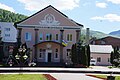
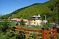
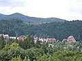
Yaremche (Ukrainian: Яре́мче, Polish: Jaremcze or Jaremcza) is a city in Nadvirna Raion, Ivano-Frankivsk Oblast (province) of west Ukraine. The city is located at the altitude of around 580 metres (1,900 ft) above mean sea level. Yaremche hosts the administration of Yaremche urban hromada, one of the hromadas of Ukraine.[1] Population: 7,907 (2022 estimate).[2]
Yaremche hosts the headquarters of the nearby Carpathian National Nature Park.
History
| Year | Pop. | ±% |
|---|---|---|
| 2007 | 11,926 | — |
| 2008 | 11,956 | +0.3% |
| 2009 | 12,007 | +0.4% |
| 2010 | 12,091 | +0.7% |
| 2016 | 12,478 | +3.2% |
| Note: Population of Vorokhta included 2010 data is valid thru October Source: Regional Statistics Office | ||
A possible root of the word "Yaremche" comes from the Turkish. In Turkic languages "yarım" means "half" and "yarımca" means "little half".[3] It was founded in 1787 and received city status on December 30, 1977. In the interwar period (1918–1939) it belonged to
There are a number of interesting houses with long sloping roofs. There is a wooden Orthodox church and an impressive rail viaduct, located over the Prut valley at the height of 30 meters (98 feet). Next to this there is a swinging pedestrian toll bridge.
On December 14, 2006, the Parliament of Ukraine, officially renamed the city from Yaremcha to "Yaremche". The decision was based on the results of a city referendum, as well as the recommendations of City Council, and Ivano-Frankivsk Oblast Council.
Until 18 July 2020, Yaremche was incorporated as a city of oblast significance and was the center of Yaremche Municipality which also included the urban-type settlement of Vorokhta, a ski resort, and five other villages: Mykulychyn, Polianytsia, Tatariv, Voronenko, and Yablunytsia.[4] The municipality was abolished in July 2020 as part of the administrative reform of Ukraine, which reduced the number of raions of Ivano-Frankivsk Oblast to six. The area of Yaremche Municipality was merged into Nadvirna Raion.[5][6]
Gallery
-
-

-
-

-
 Greek-Catholic church
 -
 Panorama
 -
 Prut river in Yaremche


.jpg)


Geography
Location
- Local orientation
Places adjacent to Yaremche | ||||||||||||||||
|---|---|---|---|---|---|---|---|---|---|---|---|---|---|---|---|---|
| ||||||||||||||||
- Regional orientation
Places adjacent to Yaremche | |
|---|---|
References
- ^ "Яремчанская громада" (in Russian). Портал об'єднаних громад України.
- ^ Чисельність наявного населення України на 1 січня 2022 [Number of Present Population of Ukraine, as of January 1, 2022] (PDF) (in Ukrainian and English). Kyiv: State Statistics Service of Ukraine. Archived (PDF) from the original on 4 July 2022.
- ^ "Türk Di̇l Kurumu". Archived from the original on 2014-03-04.
- ^ Yaremche at Verkhovna Rada web-site
- ^ "Про утворення та ліквідацію районів. Постанова Верховної Ради України № 807-ІХ". Голос України (in Ukrainian). 2020-07-18. Retrieved 2020-10-03.
- ^ "Нові райони: карти + склад" (in Ukrainian). Міністерство розвитку громад та територій України. 17 July 2020.
External links
- The Parliament renamed Yaremcha
- Yaremche - photographs
- Yaremche
| International | |
|---|---|
| National | |