
Yichang
Yichang
宜昌市 Ichang | ||
|---|---|---|
Licence plate prefixes 鄂E | | |
| Website | en | |
| Yichang | ||
|---|---|---|
Hanyu Pinyin Yíchāng | | |
| Wade–Giles | I2-ch'ang1 | |
| IPA | [ǐ.ʈʂʰáŋ] | |
Yichang (
History
In ancient times Yichang was known as Yiling. Historical records indicate that in the year 278 BC, during the
Under the
During the
In 1940, the
Administrative divisions
Administratively, it is a
- ) - includes the city center
- ) - southeastern parts of the urban area and suburbs
- ) - the part of the urban area southwest of the Yangtze (across from the city center) and suburbs
- )
- ) - northern part of the urban area and suburbs
- Zhijiang City (枝江市)
- )
- Dangyang City (当阳市)
- Yuan'an County (远安县)
- Xingshan County (兴山县)
- Zigui County (秭归县) - a county whose seat (Maoping) is some 50 kilometers (31 mi) west of downtown Yichang, next to the Three Gorges Dam
- Changyang Tujia Autonomous County (长阳土家族自治县)
- Wufeng Tujia Autonomous County (五峰土家族自治县)
Administrative map
The prefecture-level city of Yichang has direct jurisdiction over 14 divisions: 5
| Map | ||||||
|---|---|---|---|---|---|---|

1 2 3 Dianjun Yiling Yidu (city) 1. Xiling 2. Wujiagang 3. Xiaoting | ||||||
| Name | Hanzi
|
Hanyu Pinyin
|
Population (2010 census) [9] |
Area (/km2) [10] |
Density (/km2) | |
| Districts | ||||||
Xiling District
|
西陵区 | Xīlíng Qū | 512,074 | 68.14 | 7,515.03 | |
Wujiagang District
|
伍家岗区 | Wǔjiāgǎng Qū | 214,194 | 84.03 | 2549.02 | |
Dianjun District
|
点军区 | Diǎnjūn Qū | 103,696 | 533.23 | 194.47 | |
Xiaoting District
|
猇亭区 | Xiāotíng Qū | 61,230 | 130.40 | 469.55 | |
Yiling District
|
夷陵区 | Yílíng Qū | 520,186 | 3,416.57 | 152.25 | |
| County-level cities | ||||||
Yidu
|
宜都市 | Yídū Shì | 384,598 | 1,354.83 | 283.87 | |
| Dangyang | 当阳市 | Dāngyáng Shì | 468,293 | 2,148.82 | 217.93 | |
| Zhijiang | 枝江市 | Zhījiāng Shì | 644,835 | 2,010.00 | 321 | |
| Counties | ||||||
| Yuan'an County | 远安县 | Yuǎn'ān Xiàn | 184,532 | 1,741.06 | 105.99 | |
| Xingshan County | 兴山县 | Xīngshān Xiàn | 231,536 | 480.20 | 73.69 | |
| Zigui County | 秭归县 | Zǐguī Xiàn | 367,107 | 2,273.80 | 161.45 | |
| Autonomous counties | ||||||
| Changyang Tujia Autonomous County |
长阳土家族自治县 | Chángyáng Tǔjiāzú Zìzhìxiàn |
388,228 | 3418.82 | 113.56 | |
| Wufeng Tujia Autonomous County |
五峰土家族自治县 | Wǔfēng Tǔjiāzú Zìzhìxiàn |
188,923 | 2,370.41 | 79.70 | |

Geography
Like most prefecture-level cities, Yichang includes both an urban area (which is labeled on less detailed maps as "Yichang") and the surrounding country area. It covers 21,084 square kilometers (8,141 sq mi) in Western Hubei Province, on both sides of the
Within the prefecture-level city of Yichang, the Yangtze is joined by a number of tributaries, including the
The central urban area of Yichang is split between several districts. On the right (northeastern) bank of the Yangtze are located
Climate
Yichang has a four-season, monsoon-influenced, humid subtropical climate (Köppen Cwa), with cool, damp and generally overcast winters, and hot, humid summers. The monthly 24-hour average temperature ranges from 5.0 °C (41.0 °F) in January to 27.7 °C (81.9 °F) in July, while the annual mean is 17.08 °C (62.7 °F). Close to 70% of the annual precipitation of 1,160 mm (46 in) occurs from May to September. With monthly percent possible sunshine ranging from 24% in January to 49% in August, the city receives 1,568 hours of bright sunshine annually, and summer is the sunniest season.
| Climate data for Yichang (1991–2013 normals, extremes 1981–2010) | |||||||||||||
|---|---|---|---|---|---|---|---|---|---|---|---|---|---|
| Month | Jan | Feb | Mar | Apr | May | Jun | Jul | Aug | Sep | Oct | Nov | Dec | Year |
| Record high °C (°F) | 22.5 (72.5) |
27.6 (81.7) |
33.0 (91.4) |
36.7 (98.1) |
38.7 (101.7) |
39.9 (103.8) |
40.7 (105.3) |
41.4 (106.5) |
39.2 (102.6) |
35.7 (96.3) |
29.8 (85.6) |
24.6 (76.3) |
41.4 (106.5) |
| Mean daily maximum °C (°F) | 8.8 (47.8) |
11.8 (53.2) |
16.6 (61.9) |
23.0 (73.4) |
27.3 (81.1) |
30.5 (86.9) |
32.7 (90.9) |
32.1 (89.8) |
28.2 (82.8) |
23.0 (73.4) |
17.2 (63.0) |
11.2 (52.2) |
21.9 (71.4) |
| Daily mean °C (°F) | 5.0 (41.0) |
7.6 (45.7) |
11.7 (53.1) |
17.7 (63.9) |
22.2 (72.0) |
25.8 (78.4) |
28.1 (82.6) |
27.4 (81.3) |
23.6 (74.5) |
18.3 (64.9) |
12.7 (54.9) |
7.3 (45.1) |
17.3 (63.1) |
| Mean daily minimum °C (°F) | 2.2 (36.0) |
4.6 (40.3) |
8.1 (46.6) |
13.6 (56.5) |
18.2 (64.8) |
22.1 (71.8) |
24.5 (76.1) |
23.9 (75.0) |
20.1 (68.2) |
14.9 (58.8) |
9.5 (49.1) |
4.4 (39.9) |
13.8 (56.9) |
| Record low °C (°F) | −9.8 (14.4) |
−4.4 (24.1) |
−1.3 (29.7) |
0.4 (32.7) |
8.8 (47.8) |
14.7 (58.5) |
18.4 (65.1) |
17.2 (63.0) |
11.4 (52.5) |
3.7 (38.7) |
−0.9 (30.4) |
−5.4 (22.3) |
−9.8 (14.4) |
| Average precipitation mm (inches) | 24.4 (0.96) |
38.7 (1.52) |
54.8 (2.16) |
92.3 (3.63) |
139.4 (5.49) |
141.8 (5.58) |
211.0 (8.31) |
191.3 (7.53) |
107.2 (4.22) |
73.8 (2.91) |
46.7 (1.84) |
18.7 (0.74) |
1,140.1 (44.89) |
| Average precipitation days (≥ 0.1 mm) | 7.7 | 9.2 | 11.0 | 12.5 | 13.3 | 12.6 | 14.7 | 13.7 | 10.5 | 10.4 | 8.3 | 7.7 | 131.6 |
| Average snowy days | 4.3 | 3.0 | 1.1 | 0 | 0 | 0 | 0 | 0 | 0 | 0 | 0.2 | 1.4 | 10 |
| Average relative humidity (%)
|
74 | 73 | 72 | 73 | 73 | 76 | 79 | 78 | 75 | 75 | 75 | 73 | 75 |
| Mean monthly sunshine hours | 65.9 | 71.9 | 103.1 | 125.8 | 132.8 | 134.1 | 157.2 | 168.4 | 126.8 | 118.6 | 103.8 | 81.1 | 1,389.5 |
| Percent possible sunshine | 20 | 23 | 28 | 32 | 31 | 32 | 37 | 41 | 35 | 34 | 33 | 26 | 31 |
| Source: China Meteorological Administration[11][12] | |||||||||||||
Transport
Air
Yichang Sanxia Airport is located in the Xiaoting District of Yichang City, 26 km (16 mi) away from the city center and 55 km (34 mi) from the Three Gorges Dam site. The airport is conveniently located, which borders Yihuang Highway in the north, Long River Golden Waterway in the south and Jiaozhi Railway in the east.
Roads and bridges

- China National Highway 318 runs east–west through most of the prefecture-level city, south of the center city
- China National Highway 209 passes through the northwestern corner of the prefecture-level city (Xingshan County)
Several provincial highways connect Yichang center city with most counties.
- Yiling District, a few km downstream from the Three Gorges Dam.
- DianjunDistricts.
- Yichang Yangtze Highway Bridge, on the Hu-Rong Expressway, downstream of Yichang center city
- Yiwan Bridge: A Railway Bridge for Yiwan Railway which connects Yichang to Chongqing by high speed trains, almost 5 km (3.1 mi)downstream from the Yiling Bridge.
There are several ferry crossings as well.
Waterways

Yichang is an important river port on the
as well.The Qing River in the southern part of the prefecture, with its cascade of dams, is an important waterway as well.
Railway
Yichang is served by several railway lines.
The
The
Demographics

As of the 2020 census, its population was 4,017,607 inhabitants of whom 1,536,012 lived in the built-up (or metro) area consisting of Yiling, Xiling, Wujiagang and Dianjun urban districts. The Xiaoting District has not yet been urbanized. Yichang prefecture-level city, is home to many members of the Tujia ethnic group, who mostly live in several counties in the south-west of the prefecture.
Yichang also formed the border between the cultures of
Education
Since 2002, Yichang City has been home of the China Three Gorges University (the result of the merger of the University of Hydraulic & Electric Engineering, Yichang and of Hubei Sanxia University), the largest comprehensive university in Hubei Province outside Wuhan, with over 20,400 full-time students.
- China Three Gorges University
- Three Gorges Vocational College of Electric Power
There are 170 secondary schools in Yichang enrolling 150,700 students. 53,900 of the citizens in Yichang hold a secondary school degree. There are 282 elementary schools being located in Yichang enrolling 156,900. 27,600 of the citizens hold secondary school degrees. 383 kindergartens located in Yichang with 78,500 children.
Economy
Yichang has long been a major transit port and distribution center of goods, and serves as the economic hub of western Hubei province and an intermediary between the major cities of Chongqing and Wuhan. Its primary industries are shipping and shipbuilding, taking advantage of its location on the Yangtze River.
Yichang prefecture is the site of many major hydroelectricity projects. The best known of them are the two huge dams on the Yangtze River: the Gezhouba Dam (located just upstream of Yichang central city) and Three Gorges Dam, which is 40 kilometers (25 mi) upstream. The Geheyan Dam and Gaobazhou Dam on the Qing River are important as well. Besides those, a huge number of medium-sized and small power plants operate on smaller rivers and streams within the prefecture.
Picture gallery
This section contains an unencyclopedic or excessive gallery of images. |

-
 Wenfo mountain
 -
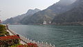
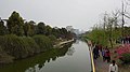
 Yangtze River
 -
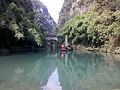
 Qing River
 -
 Guanzhuang Reservoir
 -
 Huangbo River
 -
 Tribe of Three Gorges
 -
 Three Gorges Waterfall
 -
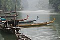 Boats on the Yangtze River, upstream from the Three Gorges
 -
 Christianity in Yichang
 -
 Roman Catholic Diocese of Yichang
 -
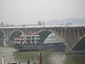
 Yichang Yangtze River Railway Bridge
 -
 Zhenjiang Pavilion
 -
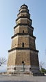 Tianran Pagoda
 -
 Statue of Quyuan
 -
 Three Gorges University
 -
 Yiling High School


See also
References
- ^ a b 宜昌市历史沿革 [Yichang City Historical Development] (in Simplified Chinese). XZQH. 14 July 2014. Retrieved 5 October 2018.
1996年,宜昌市面积21338平方千米,{...}2010年第六次人口普查,宜昌市常住总人口4059686人,其中:西陵区512074人,伍家岗区214194人,点军区103696人,猇亭区61230人,夷陵区520186人,远安县184532人,兴山县170630人,秭归县367107人,长阳土家族自治县388228人,五峰土家族自治县188923人,宜都市384598人,当阳市468293人,枝江市495995人。
- ^ "China: Húbĕi (Prefectures, Cities, Districts and Counties) - Population Statistics, Charts and Map".
- ISBN 978-7-5037-7847-6. Archived from the originalon 2017-03-01. Retrieved 2017-06-05.
- ^ "Yichang Information". Archived from the original on 2009-02-26. Retrieved 2009-12-06.
- ^ 'Yichang Evacuation Monument'; http://easternjourney.com/2009/10/yichang-evacuation-monument/ retvd 12 7 17
- ^ 抗战中的宜昌大撤退:保留中国抗战工业命脉的壮举. 15 April 2015.
- National Bureau of Statistics of the People's Republic of China. 2017. Retrieved 5 October 2018.
统计用区划代码 名称 420501000000 市辖区 420502000000 西陵区 420503000000 伍家岗区 420504000000 点军区 420505000000 猇亭区 420506000000 夷陵区 420525000000 远安县 420526000000 兴山县 420527000000 秭归县 420528000000 长阳土家族自治县 420529000000 五峰土家族自治县 420581000000 宜都市 420582000000 当阳市 420583000000 枝江市
- ^ 吴月, ed. (21 May 2018). 宜昌概况 [Description of Yichang] (in Simplified Chinese). Yichang People's Government. Retrieved 5 October 2018.
【行政区划】2016年,宜昌市辖13个县市区,即远安县、兴山县、秭归县、长阳土家族自治县、五峰土家族自治县、宜都市、枝江市、当阳市、夷陵区、西陵区、伍家岗区、点军区、猇亭区,共设20个乡、67个镇、23个街道。2016年,全市行政区划及其名称未作调整。
- ^ 宜昌市2010年第六次全国人口普查主要数据公报 (in Simplified Chinese). Yichang Statistics Bureau. May 30, 2011. Retrieved 5 December 2013.
- ^ 宜昌市土地利用总体规划(2006-2020年) (in Simplified Chinese). Yichang Bureau of Land Resources. Nov 18, 2013. Retrieved 5 December 2013.
- ^ 中国气象数据网 – WeatherBk Data (in Simplified Chinese). China Meteorological Administration. Retrieved 11 June 2023.
- ^ "Experience Template" 中国气象数据网 (in Simplified Chinese). China Meteorological Administration. Retrieved 28 May 2023.
- ^ 3个月后宜昌火车站可进出动车 低站台改造成高站台. huochepiao.com. October 2012.
- ^ "Yichang". Discover China. Retrieved 2020-01-25.
- ^ Construction of Hanyi Railway to Kick off, Wuhan City Government web site, 2008-07-10
Further reading
External links
- Official website of Yichang Government - English version Archived 2019-10-21 at the Wayback Machine