
Zürichhorn
Zürichhorn is a

_-_linkes_Limmatufer_-_Z%C3%BCrichhorn_2013-04-03_16-24-53.JPG)
Geography
Zürichhorn was formed mainly by the Hornbach stream, also known as Wildbach and Werenbach, which flows, as of today embedded into a concrete canal, between Tiefenbrunnen lido and the landing gate of the
Transportation
Zürichhorn can be reached preferably by foot (20 minutes from Bellevue) or by public transportation:
Water airport Zürichhorn

_-_Z%C3%BCrich-Landid%C3%B6rfli_(Z%C3%BCrichhorn)_1939.jpg)
In summer 1910 Wagenfabrik C. & R. Geissberger provided first test flights with so-called Hydroplanes (
Quaianlagen
Sights include the spacious parks and quais with various sculptures including
Among the many major events at Zürichhorn are the Schweizerische Landesausstellung 1939 (Swiss national exposition, commonly Landi39),
-
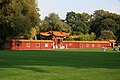 Chinese Garden
 -

-
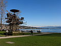 Jean Tinguely's Heureka
 -
 Kugelbrunnen, a relict of the Phenomena exhibition of 1984
 -
 Alopochen aegyptiacusat Zürichhorn
 -
 Restaurant Fischstube
 -
 Casino Lake Side Zürichhorn
 -
-
 Paddle steamer Stadt Zürichat Zürichhorn landing gate


History
In 1238 the Otinbach stream is first mentioned, which can be derived from "Otto's stream" respectively

In the 16/17th century rich Zürich citizens built their country seats outside the town walls of the city of Zürich on lakeshore in the Seefeld quarter. In the 1840s several construction companies settled around Zürichhorn: Raw material was delivered on the lake respectively shore-based on (as of today) Fröhlichstrasse. The then Hornegg was developed until the end of the 19th century as the local center of construction and ship building companies. In 1894 the railway line Rechtsufrige Zürichseebahn was established, since then most of the companies moved to the more attractive Industriequartier in the western parts of the city of Zürich.[2]
1879/81 the Wildbach has been corrected to avoid recurrent floodings of the former municipality of Riesbach (as of today Zürich's district number 8). The stream was discharged to the south of Lake Zürich, and from then, it was called Hornbach nearby its mouth. Opening the Lake Zürich quais, in 1887 the park area was expanded from Seefeld-Quai to Zürichhorn, in order to promote companionship, recreation and amusement. A spacious park landscape was built by the landscape architects Otto Froebel and Evariste Mertens.[8]
Cultural heritage of national importance
Zürichhorn is listed in the
References
- ^ Zürichsee-Schiffahrtsgesellschaft (ZSG): Fleet
- ^ a b Website Gang dur Alt-Zürich: Das Zürichhorn und die Zivilaviatik
- ^ "Seefeldquai" (in German). Grün Stadt Zürich. Retrieved 2015-01-04.
- ^ "Blatterwiese" (in German). Tiebau- und Entsorgungsdepartement Stadt Zürich. Retrieved 2015-01-04.
- ^ Pascal Ritter (2016-05-29). "Streit um Corbusier-Haus: Respektlose Namenstilgung empört Museumsgründerin" (in German). Limmattaler Zeitung. Retrieved 2016-05-30.
- ^ Website Restaurant Fischstube
- Tages Anzeiger (January 29, 2010): Die Fischstube am Zürichhorn wird im alten Stil neu gebaut
- ^ a b Official website of the city of Zürich (Grün Stadt Zürich): Zürichhorn
- ^ Website Cicerone Performance: Die Oetenbachgasse in der minderen Stadt
- Staatsarchiv des Kantons Zürich. Retrieved 2015-08-05.
- ^ "A-Objekte KGS-Inventar" (PDF). Schweizerische Eidgenossenschaft, Amt für Bevölkerungsschutz. 2015-01-01. Retrieved 2015-09-13.
External links
| Settlements |
|   | |||||||||
|---|---|---|---|---|---|---|---|---|---|---|---|
| Islands | |||||||||||
| Rivers | |||||||||||
| Valleys | |||||||||||
| Mountains | |||||||||||
| Landmarks | |||||||||||
| Transportation |
| ||||||||||
| People | |||||||||||