
Zakarpattia Oblast
Zakarpattia Oblast
Закарпатська область Kárpátalja | |
|---|---|
| Zakarpatska oblast[1] | |
 Synevyr National Nature Park is located in the Ukrainian Carpathians | |
|
Mukachivskyi Raion.[6] |
Zakarpattia Oblast (
Zakarpattia Oblast was established on 22 January 1946, after Czechoslovakia gave up its claim to the territory of Subcarpathian Ruthenia (Czech: Podkarpatská Rus) under a treaty between Czechoslovakia and the Soviet Union. The territory of Subcarpathian Ruthenia was then taken over by the USSR and became part of the Ukrainian SSR.
During the Ukrainian independence referendum held in 1991, Zakarpatska Oblast voters were given a separate option on whether or not they favoured autonomy for the region.[7] Although a large majority favoured autonomy, it was not granted.[7] However, this referendum was about self-government status, not about autonomy (like in Crimea).[8]
Situated in the
With a land area of almost 13,000 square kilometres (5,000 sq mi), the oblast is ranked
Name
The oblast is also referred to as the Transcarpathian Oblast, Transcarpathia, Zakarpattia (Ukrainian: Закарпаття, romanized: Zakarpattia), or historically as Subcarpathian Rus'. In other languages the oblast is named:
- Hungarian: Kárpátalja, literally: "Base of the Carpathians"
- Slovak and Czech: Zakarpatská oblast; Podkarpatská Rus
- Polish: Obwód zakarpacki
- Romanian: Regiunea Transcarpatia ([red͡ʒiˈune̯a transkarˈpat͡i.a])
- Russian: Закарпатская область, translit. Zakarpatskaya oblast
- Ukrainian and Rusyn: Закарпатська область
While the name Transcarpathia is a translation of the Ukrainian version of the name, the Hungarian name translates as Subcarpathia, following the Hungarian language logic "feet of the mountains", naming a territory after its geographic location at the lower section of a mountain range. (Following the same language pattern that applies to the name of the sub-Alpine territory in Western Hungary, Alpokalja)[9]
Generally, the Transcarpathia name and its versions reflect the East Slavic language logic, while some Western languages follow the same logic as the Hungarian:[10]
- English: Subcarpathia, Subcarpathian Rus', Subcarpathian Ruthenia, Sub-Carpathian Ukraine
- French: Ukraine Subcarpathique
Other Western languages follow their own logic in creating a name for the region:
- German: Karpatenrussland, Karpatenland, Karpathenland, Karpatho-Russland, Karpatenukraine, Karpato-Ukraine
The
Geography

The Zakarpattia Oblast has a total area of 12,800 km2 (4,942 sq mi) and is located on southwestern slopes and foothills of the
The Zakarpattia Oblast mostly consists of mountains and small hills covered with
The largest rivers that flow through the oblast include the
The region's climate is moderate and
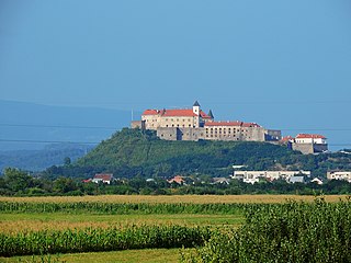
Four of the oblast's historical-cultural sites were nominated for the
-
 Morning in the Carpathian Biosphere Reserve
 -
 Svydovets (Drahobrat) Waterfall
 -
 A bear inSynevyr National Nature Park
 -
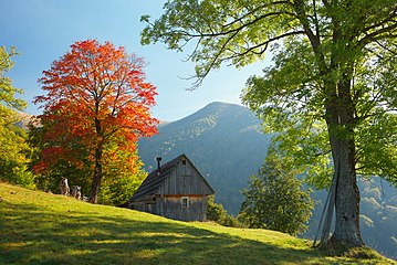 Landscape in Khust Raion


History


According to the
According to the Gesta Hungarorum, as Prince Álmos entered on the castle of Hung and there he appointed his son Árpád as the primary ruler, hence he was called of the leader of Hungvária, while all of his valiant soldiers as Hungvárus, so since then all the Magyars have been known by this name internationally.
In 895 the Hungarian tribes entered the Carpathian Basin from here through the Verecke pass, and the lands of Transcarpathia were influenced by the Principality of Hungary since 895, which transformed the Kingdom of Hungary in 1000. In Transcarpathia, the Voivodeship of Maramureș, granted to a small Romanian nobility, was established in 1343. The region was reorganized into the Máramaros County in 1402.
Since 1867, it was part of the

The province has a unique footnote in history as the only region in the former Czechoslovakia to have had an
Following the Munich Agreement, the southern part of the region was awarded to
The Hungarian invasion was followed by a few weeks of terror in which more than 27,000 people were shot dead without trial and investigation.[20] Over 75,000 Ukrainians decided to seek asylum in the Soviet Union; of those almost 60,000 died in Gulag prison-camps.[20] Others joined the Czechoslovak Army.[20]

The major Jewish communities of the region had existed in
In October 1944, the region was occupied by the
Zakarpattia in the Soviet Union
Between 1945 and 1947, the new Soviet authorities fortified the new borders, and in July 1947 declared Transcarpathia as "restricted zone of the highest level", with checkpoints on the mountain passes connecting the region to mainland Ukraine.[23]
In December 1944, the National Council of Transcarpatho-Ukraine set up a special people's tribunal in
After breaking the Greek Catholic Church in Eastern Galicia in 1946, Soviet authorities pushed for the return to Orthodoxy of Greek-Catholic parishes in Transcarpathia too, including by engineering the accident and death of recalcitrant bishop Theodore Romzha on 1 November 1947. In January 1949, the Greek Catholic Eparchy of Mukachevo was declared illegal; remaining priests and nuns were arrested, and church properties were nationalised and parcelled for public use or lent to the Russian Orthodox Church (Moscow Patriarchate) as the only accepted religious authority in the region.[7]
Cultural institutions were also forbidden, including the russophile Dukhnovych Society, the ukrainophile Prosvita, and the Subcarpathian Scholarly Society. New books and publications were circulated, including the Zakarpatsk'a Pravda (130,000 copies). The Uzhhorod National University was opened in 1945. Over 816 cinemas were open by 1967 to insure the indoctrination of the population with Marxist-Leninist propaganda. The Ukrainian language was the first language of instruction in schools throughout the region, followed by Russian, which was extensively used at the university level. Most new generations had a passive knowledge of the Rusyn language, but no knowledge about local culture. XIX-century Rusyn intellectuals were labelled as "members of the reactionary class and instruments of Vatican obscurantism". The Rusyn anthem and hymn were banned from public performance. Carpatho-Rusyn folk culture and songs, which were promoted, were presented as part of Transcarpathian regional culture as a local variant of Ukrainian culture.[7]
As early as 1924, the
Already in February 1945, the National Council proceeded to confiscate 53,000 hectares of land from big landowners and redistribute it to 54,000 peasant households (37% of the population). Forced collectivisation of land started in 1946; around 2,000 peasants were arrested during protests in 1948–49 and sent for forced labour in the Gulag. Collectivisation, including of mountain shepherds, was completed by May 1950. Central planning decisions set Transcarpathia to become a "land of orchards and vineyards" between 1955 and 1965, planting 98,000 hectares with little results. Attempts to cultivate tea and citrus also failed due to climate. Most vineyards were uprooted twenty years later, during Mikhail Gorbachev's anti-alcohol campaign in 1985–87.[7]
The Soviet period also meant the upscaling of industrialisation in Transcarpathia. State-owned lumber mills, chemical and food-processing plants widened, with Mukachevo's tobacco factory and Solotvyno's salt works as the biggest ones, providing steady employment to the residents of the region, beyond the traditional subsistence agriculture. And while traditional labour migration routes to the fields of Hungary or the factories of the Nort-West United States were now closed, Carpathian Ruthens and Romanians could now move for seasonal work in Russia's North and East.[7]
The inhabitants of the oblast grew steadily in the Soviet period, from 776,000 in 1946 to over 1,2 million in 1989. Uzhgorod increased its residents five-fold, from 26,000 to 117,000, and
Zakarpattia in independent Ukraine
After the
At the first Presidential elections in Ukraine in 1991, voters from Transcarpathia supported Leonid Kravchuk by 58%. At the 1994 Ukrainian parliamentary election, Transcarpathia elected 9 independent MPs over 11 to the Rada. The same year, voters in the region supported the incumbent Leonid Kravchuk over Leonid Kuchma by 70.5% At the
At the 2002 Ukrainian parliamentary election, voters from Transcapathia supported the Our Ukraine Bloc, in line with voters from all Western Ukraine. At the 2004 Ukrainian presidential election, Transcarpathians voted in majority for Viktor Yushchenko. At the 2006 Ukrainian parliamentary election, voters from Transcapathia supported the Our Ukraine Bloc and the Yulia Tymoshenko Bloc, in line with voters in Ciscarpatian East Galizia. At the 2007 Ukrainian parliamentary election, the Our Ukraine–People's Self-Defense Bloc linked with former President Viktor Yushchenko won in most of the region, while the Yulia Tymoshenko Bloc came out first in Uzhhorod and its raion.
On 7 March 2007, the Zakarpattia Oblast Council recognized the Rusyn ethnicity.[24][25]
On October 25, 2008, 100 delegates to the Congress of Carpathian Ruthenians declared the formation of the "Republic of Carpathian Ruthenia".

At the 2010 Ukrainian presidential election, Yulia Tymoshenko won in most raions of Transcarpathia save for Mukachevo, Berehove and Vynohradiv, where Viktor Yanukovych gained a majority.
In the
In the 2014 presidential election, Transcarpathia helped elect Petro Poroshenko as president of Ukraine. Turnout in the east of the region was among the lowest in Ukraine, below 40%, while it reached 65% in its west. At the
Ukraine's 2017 education law makes Ukrainian the required language of study in state schools.[30][31] Since 2017, relations between Ukraine and Hungary rapidly deteriorated over the issue of the Hungarian minority in Ukraine.[32]
Transcaparthian voters supported
At the
Politics

Zakarpattia Oblast's local administration is controlled by the Zakarpattia Oblast Council (rada).
The oblast's governor is appointed by the President of Ukraine.[33]
2020
Distribution of seats after the 2020 Ukrainian local elections
- 12 Native Zakarpattia
- 11 Servant of the People
- 8 Fatherland
- 8 Party of Hungarians
- 7 Andriy Baloha's Team
- 6 European Solidarity
- 6 For the Future
- 6 Opposition Platform — For Life
Election date was 25 October 2020[34]
2015
Distribution of seats after the 2015 Ukrainian local elections
- 19 United Centre
- 15 Solidarity
- 11 Revival
- 8 Party of Hungarians
- 7 Fatherland
- 4 Opposition Bloc
Election date was 25 October 2015[35]
Administrative divisions


On 18 July 2020, the number of raions (districts) was reduced to six.[36][37]
Zakarpattia Oblast was previously subdivided into 13
Zakarpattia Oblast incorporates four unofficial geographic-historic regions (counties):
The oblast (region) was divided into 13 raions and five cities of regional importance including the administrative centre Uzhhorod. Administrative centres of raions may be located within a city of regional importance, while such city is not technically a part of the raion. A city of regional significance may consist of an individual populated place or be complex of several settlements (the city proper and suburbs) which are governed by own radas (councils).
Further, each raion is divided into radas (councils). Cities and towns (urban-type settlements) all have own individual councils, while villages and rural settlements may be formed into multiple settlements councils or an individual village council. All cities are either of regional importance or of district importance.
Raions after 2020
- Berehove (Берегівський район), the center is in the town of Berehove
- Khust (Хустський район), the center is in the town of Khust
- Mukachevo (Мукачівський район), the center is in the town of Mukachevo
- Rakhiv (Рахівський район), the center is in the town of Rakhiv
- Tiachiv (Тячівський район), the center is in the town of Tiachiv
- Uzhhorod (Ужгородський район), the center is in the city of Uzhhorod
Raions before 2020
There were 13 raions (districts) in the oblast until 2020:
- Berehove Raion (54,062) w/o Berehove city
- Irshava Raion (100,905)
- Khust Raion (96,960) w/o Khust city
- Mizhhiria Raion (49,890)
- Mukachevo Raion (101.443) w/o Mukacheve city
- Perechyn Raion (32,026)
- Rakhiv Raion (90,945)
- Svaliava Raion (54,869)
- Tiachiv Raion (171,850)
- Uzhhorod Raion (74,399) w/o Uzhhorod city and Chop city
- Velykyi Bereznyi Raion (28,211)
- Volovets Raion (25,474)
- Vynohradiv Raion (117,957)
Urban settlements
Largest cities or towns in Zakarpattia Oblast
Source? | |||||||||
|---|---|---|---|---|---|---|---|---|---|
| Rank | Raion | Pop. | |||||||
Mukacheve
|
1 | Uzhhorod | Uzhhorod* | 115,520 |  Khust  Vynohradiv | ||||
| 2 | Mukacheve |
Mukacheve* | 86,061 | ||||||
| 3 | Khust | Khust* |
28,643 | ||||||
| 4 | Vynohradiv | Vynohradiv | 25,565 | ||||||
| 5 | Berehove | Berehove* | 24,458 | ||||||
| 6 | Svaliava | Svaliava | 17,027 | ||||||
| 7 | Rakhiv | Rakhiv | 15,243 | ||||||
| 8 | Dubove |
Tiachiv | 9,775 | ||||||
| 9 | Mizhhirya |
Mizhhirya |
9,616 | ||||||
| 10 | Korolevo | Vynohradiv | 9,339 | ||||||
Cities of regional significance

- Uzhhorod (116,400)
- Mukachevo (93,738)
- Khust (31,083)
- Berehove (Beregszász) (24,274)
- Chop (Csap) (8,436)
Other urban settlements
- Vynohradiv (Nagyszőlős) (27,600)
- Rakhiv (Rahó) (17,000)
- Svaliava (16,217)
- Tiachiv (Técső) (9,256)
- Mizhhiria (9,133)
- Irshava (9,000)
- Velykyy Bychkiv(8,920)
- Solotvyno (Slatina, Aknaszlatina) (8,774)
- Dubove(8,745)
- Velyki Luchky (8,540)
- Ilnytsia (8,420)
- Bushtyno (8,091)
Demographics
According to the
Ukrainians and the
Out of 1,010,100 Ukrainians in the region, 99.2% (~1,002,019) identified their native language as Ukrainian, while about 0.5% (~5,051) consider their native language to be Russian. Out of 151,500 Hungarians, 97.1% (~147,107) consider their native language to be Hungarian, while about 2.6% (~3,939) consider their native language to be Ukrainian. Out of the 32,100 officially recorded Romanians, 99.1% (31,811) identified their native language to be Romanian, while 0.6% (~193) consider their language Ukrainian. Out of 31,000 Russians, 91.6% (28,396) identified their native language as Russian, while 8.1% (~2,511) consider their language Ukrainian. Out of 14,000 Romani peoples only 20.7% (2,898) identify their native language as Romani, while 62.9% (~8,806) consider their language Ukrainian or Russian. Out of 5,600 Slovaks 43.9% (2,458) identify their native language as Slovak, while 42.1% (~2,358) consider their language Ukrainian. Out of 3,500 Germans, 50.0% (1,750) acknowledge their native language, while 38.9% (~1,362) consider their language Ukrainian. About 81% of the oblast population considers the Ukrainian language their native language, while 12.7% of population gives consideration to the Hungarian language and just over 5% considers either the Russian or Romanian languages.
Around two thirds are Eastern Orthodox and about a quarter are Catholic. The largest denomination is the
| Nationality | Number | in 2001 (%) | in 1989 (%) | growth (%) |
|---|---|---|---|---|
| Ukrainians (incl. Rusyns) | 1,010,100 | 80.5 | 78.4 | +3.4% |
| Hungarians | 151,500 | 12.1 | 12.5 | -2.7% |
| Romanians | 32,100 | 2.6 | 2.4 | +9.0% |
| Russians | 31,000 | 2.5 | 4.0 | -37.3% |
| Roma | 14,000 | 1.1 | 1.0 | +15.4% |
Slovaks
|
5,600 | 0.5 | 0.6 | -22.3% |
| Germans | 3,500 | 0.3 | 0.3 | +3.0% |
| Year | Fertility | Birth | Year | Fertility | Birth | Year | Fertility | Birth |
|---|---|---|---|---|---|---|---|---|
| 1990 | 2,2 | 21 251 | 2000 | 1,5 | 14 481 | 2010 | 1,9 | 18 301 |
| 1991 | 2,2 | 21 059 | 2001 | 1,4 | 13 699 | 2011 | 1,9 | 18 460 |
| 1992 | 2,2 | 20 559 | 2002 | 1,5 | 14 207 | |||
| 1993 | 2,0 | 19 264 | 2003 | 1,5 | 14 747 | |||
| 1994 | 1,9 | 17 725 | 2004 | 1,5 | 15 472 | |||
| 1995 | 1,8 | 17 320 | 2005 | 1,6 | 15 750 | |||
| 1996 | 1,7 | 16 473 | 2006 | 1,7 | 16 530 | |||
| 1997 | 1,6 | 15 708 | 2007 | 1,7 | 16 833 |
Their languages and culture are respected by the provision of education, clubs, etc. in their respective languages. Those who recognize Ukrainian as their native language total 81.0% of the population,
Zakarpattia is home to approximately 14,000 ethnic Roma (Gypsies), the highest proportion of Roma in any oblast in Ukraine. The first Hungarian College in Ukraine is in Berehove, the II. Rákoczi Ferenc College.
Beside the major ethnic groups, Zakarpattia is home to several ethnic sub-groups such as
Religion
Religion in Zakarpattia Oblast (2021)[46]
According to a 2021 survey, 31% of the religious community of Zakarpattia Oblast adheres to Catholicism, while 36% belong to the Eastern Orthodoxy and 20% are Protestants.[46] Only one percent of the population does not follow any religion.[44]
The Catholic community of Zakarpattia is divided as follows:
- Roman Catholic – 17%
- Greek Catholic – 83%
The Greek Catholic community falls under the Greek Catholic Eparchy of Mukachevo, associated with the Ruthenian Greek Catholic Church.
The Orthodox community of Zakarpattia is divided as follows:
- Ukrainian Orthodox Church of the Kyivan Patriarchate (today Orthodox Church of Ukraine) - 42%
- Ukrainian Orthodox Church of the Moscow Patriarchate – 33%
- Non-denominational – 25%
Age structure
- 0–14 years: 19.1%
 (male 123,009/female 116,213)
 - 15–64 years: 69.8%
 (male 428,295/female 445,417)
 - 65 years and over: 11.1% (male 48,826/female 89,800) (2013 official)
Median age
- total: 35.1 years
- male: 33.2 years
- female: 37.1 years (2013 official)
Economy

Situated in the Carpathian Mountains, Zakarpattia Oblast's economy depends mostly on trans-border trade, vinery and forestry. The oblast is also home to a special economic zone.[47][48]
The oblast's main industry includes woodworking. Other industries include food, light industry, and mechanical engineering. The foodstuffs segment in the structure of ware production of national consumption is 45%. The total number of large industrial organisations is 319, compared to 733 small industrial organisations.[12]
The most common crops grown within the region include cereals, potatoes and other vegetables. In 1999, the total amount of grain produced was 175,800 tons, of sunflower seeds — 1,300 tons, and potatoes — 378,200 tons.[12] The region also produced 76,100 tons of meat, 363,400 tons of milk and 241,900,000 eggs.[12] The total amount of registered farms in the region was 1,400 in 1999.[12]
In 2011 it had a gross regional product worth ₴18,100,000,000
Culture
This section needs expansion. You can help by adding to it. (June 2011) |

Wooden churches
- Sredne Vodyane churches
- Verkhnye Vodyane church
- Danylovo church
- Kolodne church
- Krainykovo church
- Nyzhnie Selyshche church
- Oleksandrivka church
- Sokyrnytsia church
- Huklyvyi church
Villages
See also
- Carpathian Ruthenia, small historical region
- Carpatho-Ukraine, a short-lived Ukrainian state on the territory
- Ruthenians and Ukrainians in Czechoslovakia
- Museum of Folk Architecture and Life, museum displaying Zakarpattia architecture
- Eparchy of Mukačevo and Prešov
- Kárpátalja football team
Gallery
-
 Petros - a peak in the Chornohora with height of 2,020 metres (6,630 ft)
 -
 Mount Pikui
 -
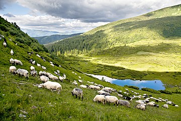 Sheep near the Lake Vorozheska
 -
-
 Cathedral of the Exaltation of the Holy Cross in Uzhhorod
 -
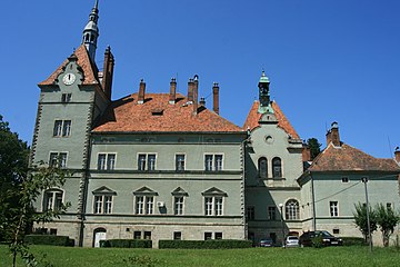 Schoenborn Castle-Palace inChynadiyovo
 -
-
 Wooden Church of St. Nicholas (1604) in Nyzhnya Apsha


.jpg)


References
- )
- ^ a b "Сьогодні Закарпаття увійшло до складу України. 68 років тому" [Today Zakarpattia became part of Ukraine. 68 years ago]. 7dniv. 29 June 2013
- ^ "Mykyta Appointed as Head of Zakarpattia Region". open4business. December 13, 2021. Archived from the original on April 28, 2022.
- ^ a b Чисельність наявного населення України на 1 січня 2022 [Number of Present Population of Ukraine, as of January 1, 2022] (PDF) (in Ukrainian and English). Kyiv: State Statistics Service of Ukraine. Archived (PDF) from the original on 4 July 2022.
- ^ "Валовии регіональнии продукт".
- ^ a b "Mukachivskyi Raion: Social data". Zakarpattia Oblast Administration. Archived from the original on 2008-02-09. Retrieved 2007-06-02.
- ^ ISBN 978-0-295-98723-1.
- ^ Kuzio, Taras. "The Rusyn Question in Ukraine: sorting out fact from fiction". Canadian Review of Studies in Nationalism. XXXII (2005).
- ^ "The name "Kárpátalja", as it appears on the cover of the journal of the Transcarpathian section of the Hungarian Writers' Union" (PDF). Retrieved 2014-03-02.
- ^ "Christian Pischlöger: Kárpátalja vagy Kárpátontúl? College of Nyíregyháza" (PDF). Retrieved 2014-03-02.
- ^ a b c d "Geography". Zakarpattia Oblast Council (in Ukrainian). Archived from the original on 2009-04-30. Retrieved 2007-11-18.
- ^ Cabinet of Ministers of Ukraine. Retrieved 2007-06-01.
- ^ a b "Transcarpathia is my region". All Zakarpattya. Archived from the original on 2007-04-04. Retrieved 2007-06-01.
- ^ "Primeval Beech Forests of the Carpathians". UNESCO World Heritage Centre. Retrieved 2007-07-04.
- ^ "Attila and the Nomad Hordes" Dr David Nicolle, 1990
- ^ "Bulgarian contributions to European civilization" Atanas Bozhkov, 1994
- ISBN 0-8020-8390-0.
- ^ Subtelny, p. 458
- ISBN 978-615-5053-46-7.
- ^ a b c d (in Ukrainian) Today is the 80th anniversary of the proclamation of the Carpathian Ukraine, Ukrinform (15 March 2019)
- ^ a b "History of the region". All Zakarpattya. Archived from the original on 2007-04-04. Retrieved 2007-06-01.
- ^ First Congress of People's Committees of Zakarpattia Ukraine (ПЕРШИЙ З'ЇЗД НАРОДНИХ КОМІТЕТІВ ЗАКАРПАТСЬКОЇ УКРАЇНИ). Ukrainian Soviet Encyclopedia.
- ^ With Their Backs to the Mountains: A History of Carpathian Rus? and Carpatho-Rusyns, by Paul Robert Magocsi, Central European University Press, 2015
- ^ "News – 7 march 2007 – The activities of local government" (in Ukrainian). Archived from the original on 2009-02-20. Retrieved 2008-12-28.
- ^ "Rusyns Recognized as Indigenous Nationality of the Transcarpathian Oblast of Ukraine". Archived from the original on 2008-07-29. Retrieved 2008-12-26.
- ^ "Svoboda Party Calls On SBU To Launch Criminal Case Against Delegates To Congress Of Carpathian Ruthenians For Declaring Carpathian Ruthenia Republic". Archived from the original on 2008-10-29. Retrieved 2008-11-06.
- ^ "Батюшці Сидору — від онука Молотова" [To Father Sidor from grandson of Molotov]. Ukraine Moloda (in Ukrainian). Retrieved 2023-06-29.
- ^ "Prosecutors File Case Against People Who Initiated Proclamation Of Carpathian Ruthenian Republic On Separatism Charges". Archived from the original on 2009-02-20. Retrieved 2008-11-06.
- ^ Interfax-Ukraine (2009-05-01). "Right-wing Svoboda 'sabotages' Ruthenian Congress in Uzhgorod - May. 01, 2009". Kyiv Post. Retrieved 2023-06-29.
- ^ "Ukrainian Language Bill Facing Barrage Of Criticism From Minorities, Foreign Capitals". Radio Free Europe/Radio Liberty. 24 September 2017.
- ^ "Criticism of Ukraine's language law justified: rights body". Reuters. 8 December 2017.
- ^ "Ukraine defends education reform as Hungary promises 'pain'". The Irish Times. 27 September 2017.
- Ukraine Today(22 July 2015)
- Central Election Commission of Ukraine
- ^ Results. Central Electorate Commission
- ^ "Про утворення та ліквідацію районів. Постанова Верховної Ради України № 807-ІХ". Голос України (in Ukrainian). 2020-07-18. Retrieved 2020-10-03.
- ^ "Нові райони: карти + склад" (in Ukrainian). Міністерство розвитку громад та територій України. 17 July 2020.
- ^ "Admin. div. reform". Zakarpat-rada-gov.ua. Archived from the original on 23 July 2012. Retrieved 9 March 2022.
- ^ 2001 Ukrainian Census. Archived from the originalon 2007-09-30. Retrieved 2007-06-01.
- ^ "Чисельність наявного населення України (Actual population of Ukraine)" (PDF) (in Ukrainian). State Statistics Service of Ukraine. Retrieved 19 July 2016.
- ^ 2001 Ukrainian Census. Retrieved 2013-01-28.
- ^ Peiu, Petrisor (2 February 2020). "Și ei sunt români. Și ei sunt ai noștri. Și ei au nevoie de România". Ziare.com (in Romanian).
- 2001 Ukrainian Census (in Ukrainian). Archived from the originalon 2009-04-30. Retrieved 2007-06-03.
- ^ a b "Релігійні вподобання населення України". infolight.org.ua. 26 May 2015. Archived from the original on 9 July 2017. Retrieved 13 March 2018.
- 2001 Ukrainian Census (in Ukrainian). Archived from the originalon 2007-09-30. Retrieved 2007-06-03.
- ^ a b "Реєстр релігійних громад Закарпатської області - Набори даних - Портал відкритих даних". data.gov.ua (in Ukrainian). Retrieved 2023-02-26.
- ^ "History of the Region". World Gazetteer. Archived from the original on 2007-04-04. Retrieved 2007-06-01.
- ^ Laws of Ukraine. Verkhovna Rada law No. 2322-III: On the official economic zone of "Zakarpattia". Adopted on 2004-03-31. (Ukrainian)
External links
- carpathia.gov.ua — Official website of Zakarpattia Oblast Administration (in Ukrainian and English)
- Zakarpattia Council official site Archived 2010-11-06 at the Wayback Machine (in Ukrainian)
- Zaholovok — Zakarpattia actual news(in Ukrainian)
- Zakarpattia essays — All about Zakarpattia and Ukraine
- Verkhovna Rada website — Zakarpattia Oblast data
- Photos and infrastructure objects of Zakarpattia on interactive map (Ukrainian Navigational Portal)
- News from Zakarpattia (in Ukrainian)
- all.zakarpattya.net — All about Zakarpattia (in English and Ukrainian)
- mukachevo.net — Zakarpattia Oblast informational portal (in Ukrainian)
- map.meta.ua — Digital map of Zakarpattia Oblast (in Ukrainian)
- Zakarpattia Oblast – photographs Archived 2007-03-19 at the Wayback Machine
- Dictionary of transcarpathian words Archived 2014-01-18 at the Wayback Machine (in Ukrainian)
| International | |
|---|---|
| National | |
| Geographic | |
| Other | |