Zhetysu
This article has multiple issues. Please help improve it or discuss these issues on the talk page. (Learn how and when to remove these template messages)
|

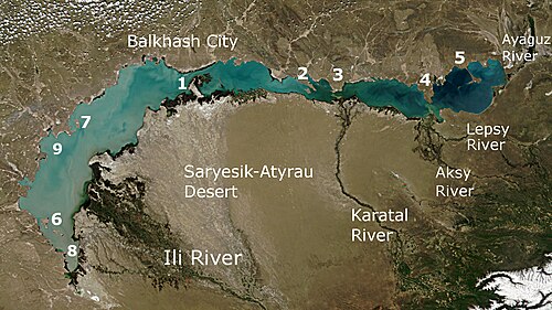
Zhetysu (Kazakh: Жетісу, romanized: Jetısu, pronounced [ʑjɪtɪsəw];[1][2] meaning "seven rivers" or more literally, "seven waters") or Jeti-Suu (Kyrgyz: Жети-Суу, romanized: Jeti-Suu, pronounced [dʒetisuː]),[a] also transcribed Zhetisu,[5][6] Jetisuw,[7][8] Jetysu,[9][10] Jeti-su[11][12] or Jity-su,[13] is a historical name of a part of Central Asia corresponding to the southeastern part of modern Kazakhstan.
The name comes from "seven rivers" in Kazakh but meant "abounding in water", in contrast to the dry steppes of the eastern Balkhash area. It owes its name to the rivers that flow from the southeast into Lake Balkhash. Zhetysu primarily falls into today's Jetisu Region and Almaty Region and other South-Eastern parts of Kazakhstan and some parts of Northern Kyrgyzstan.
Geography
The lands of the 19th-century

The
Climate

The climate in Zhetysu is thoroughly continental. In the Balkhash steppes the winter is very cold. The lake freezes every year, with temperatures falling to −11 °C (13 °F). In the Ala-kul steppes the winds blow away the snow. The passage from winter to spring is very abrupt, and the steppes are rapidly clothed with vegetation, which, however, is soon scorched by the sun. Average temperatures at
Bodies of water

The most important river is the
Population
The population was estimated in 1906 as 1,080,700. Kazakhs formed 76% of the population, Russians 14%, Taranchi (Uyghurs) 5.7%.
History and administration
History of the central steppe has an outline history with links to the many peoples who lived in this area.
In the VI-III vv. BC. e. the


The area belonged to
From 1867 to 1884 this province was made part of

Before the

After the
Derived names
The name of
See also
- Sapta Sindhu, the 7 rivers of Indian subcontinent
Notes
References
- ISBN 978-0-947623-19-7.
Jeti-suu
- ISBN 978-0-415-50353-2.
Jeti Suu{...}Seven Waters
- ISBN 978-1-134-21137-1.
The Qarluqs conquered the entire province of Yedi-Su
- ISBN 0-203-45135-X.
Participated in the 1916 uprising in Yedi Su.
- ^ "Five-star hotel, recreation areas to open this year on Alakol Lake". Astana Times. 8 February 2018. Retrieved 27 April 2020.
Tourism in Zhetisu, one of the most picturesque regions in Kazakhstan, is on the rise.
- Kazakh TV. 15 December 2017. Archivedfrom the original on 2021-12-12. Retrieved 27 April 2020.
- ^ Katariya, Adesh (25 November 2007). "Ancient History of Central Asia: Yuezhi origin Royal Peoples: Kushana, Huna, Gurjar and Khazar Kingdoms". p. 33.
"Sedmorechie" today (in Russian), meaning "Seven rivers" (Kazakh- Zhetisu, Jetisuw, Jetysu)
- JSTOR 26571579.
Rebellious eastern clans founded the Kazak Horde in the Jeti-suw region (to the south of Balkash Lake).{...}The Kazak Horde was established in the Jeti-suw region (1456) as a vassal state to Moghulistan
- . Retrieved 27 April 2020.
Jetysu («Seven Rivers» from Kazakh «jety» — «seven», «su» — «water») is a vast region in the historical and cultural aspect, located in the southeast of Kazakhstan. Jetysu is surrounded by steppes and foothills of Saryarka, Kazakh Altay, Central Asia and Eastern Turkestan.
- .
- ^ Said Galimzhanov; Assiya Galimzhanova; Lyazat Nurkusheva; Mihribanu Glaudinova; Gauhar Sadvokasova; Larissa Brylova; Hvaydolla Esenov (August 2018). "THE ARCHAEOLOGICAL LANDSCAPES OF TAMGALY AND ESHKIOLMES SANCTUARIES RELIGIOUS BELIEFS AND CULT CEREMONIES" (PDF). European Journal of Science and Theology. 14 (4): 166. Retrieved 27 April 2020.
Performed in the sanctuaries for many centuries, numerous sacrificial rites testify to the stability of religious rites on the territory of Jeti-Su.
- ISBN 1-85109-661-2.
Jeti-Su the Jeti-su has been a key region of Central Asia for at least a millennium.
- ^ Congress, Library of (2011). "Library of Congress Subject Headings". p. 4205.
Jity-su (Kazakhstan)
- ^ "History". kazembro.kz.
- ^ Administrator. "HISTORY OF STATES ON THE TERRITORY OF KAZAKHSTAN". www.scientificfund.kz.
- ISBN 978-0-7607-3203-8.
- ISBN 978-1-56324-724-8.
- ^ "温宿县人民政府 领导致词" [Wensu County People's Government - Address by the Leaders] (in Chinese). 温宿县人民政府. 2019-03-22. Retrieved 30 November 2019.
温宿,维吾尔语意为"十股水"
- ^ 阿克苏市概况. 阿克苏市人民政府 (in Simplified Chinese). Retrieved 18 May 2020.
阿克苏市,维吾尔语意为"白水城",
- ^ Ole Olufsen (1904). Through the Unknown Pamirs. William Heinemann. p. 5 – via Internet Archive.
The Kizilsu Surkhab (Kizilsu being Turkish for Red Water, and Surkhab the Persian for Red Water) has its source near the psas of Ton Murum in Transalai, and, with it broad fertile valley, forms the boundary between the Alai mountains and Transalai, the most northerly range of Pamir.
