
Zipaquirá
This article includes a list of general references, but it lacks sufficient corresponding inline citations. (July 2019) |
Zipaquirá | |
|---|---|
Municipality and city | |
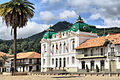
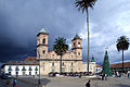
 Central square of Zipaquirá | |
|
UTC-5 | |
| Area code | +1 |
| Website | Official website |
| Censo DANE 2005 | |


Zipaquirá (Spanish pronunciation: [sipakiˈɾa]) is a municipality and city of Colombia in the department of Cundinamarca. Its neighboring municipalities are Cogua and Nemocón to the north; Tocancipá to the east; Tabio, Cajicá and Sopó to the south; and Subachoque and Pacho to the west. Its seat of municipal government is 49 kilometers from the national capital Bogotá. It is part of the Greater Bogotá Metropolitan Area, and is the capital of the Sabana Centro province. It is also the headquarters of the diocese of the same name and that includes much of the Department of Cundinamarca, extending to the centre of Bogotá, the region of Rionegro, the Ubaté Valley, and the region of Guavio.
The city is primarily known for its
Etymology
In
History
Pre-conquest era
In the
There are two possible origins of its name. One of them is taken from the indigenous people who inhabited the foot of the Zippa mountain range, "Chicaquicha", which means "our large wall" or according to other sources, "city of our father", and until the 19th century the name was written beginning with the letter C. The other possibility refers to the name "zipa", a title conferred to the governor of the village and to his wife, the latter known by the title of "Quira", and thus "Zipa-Quirá". The native people who lived there settled in the upper part of the mine called "Puebla Viejo", now known as Santiago Pérez, approximately 200 meters above the present site of the city, and where early Spanish descriptions (1537) speak of "seeing a few hundred dwellings with a population of 12,000 people".
These lands were part of the domain of the .
New Kingdom of Granada
On July 18, 1600, Don oidor Luis Henríquez established a settlement on the site with workers and their families, and named it the "Village of Zipaquirá".
On August 2, 1600, Henríquez contracted Juan de Robles to construct the Church of Zipaquirá, which was later reconstructed by Pedro de Tovar y Buendía, when the parish priest was Fernando de Buenaventura y Castillo.
In 1605 the area was named the Corregimiento de Zipaquirá and removed to its original location; this was done due to the limited area available on the originally occupied plain, as well as to the fact that the Spanish forces ordered that no Spanish,
In 1623, the Spanish official Don Francisco de Sosa named as wards the 321 native inhabitants in the "Old Town", according to the declaration of Alfredo Tinoco.
On October 5, 1638, Gabriel de Carvajal became the guardian of 771 natives in the region and 125 in Tibitó.
In 1778, by order of the Viceroy Manuel Antonio Flórez, the natives who lived in Zipaquirá were transported to Nemocón in order to prevent constant rebellions of previous owners of the salt deposits.
On August 3, 1779, Zipaquirá saw the creation of the Holy Trinity and San Antonio de Padua parish.
In 1852, Zipaquirá became a province, retaining the status until 1855.
During the Spanish reconquest, on August 3, 1816, the so-called Zipaquirá Martyrs were executed in the city square.
Republican era
With the Constitution of Cundinamarca of 1815, the city became the capital of the province of the same name. On July 10, 1863, it was designated the capital of the Sovereign State of Cundinamarca, although subsequently it was named Funza by decree of president Morales. Law number 46 of April 29, 1905, created the Department of Quesada, the capital of which was Zipaquirá, which remained so until 1910.
Geography and description
Zipaquirá is located 48 kilometres (30 mi) north of
The city has undergone recent changes, having transformed streets in the center to
Currently, the Bogotá - Chía - Cajicá - Zipaquirá highway is completed, making possible more rapid and safer access to the city, since the Cajicá - Zipaquirá segment was one of the most accident-prone roads in the country.
Zipaquirá offers the visitor typical restaurants, colonial houses that are almost 300 years old, tourist agencies, recreation centers such as Panaca Sabana, museums, crafts, and an interesting retail infrastructure.
Agriculture is also important in the municipality, especially dairy and potato farming. Industry in the region is closely associated with the production, processing, and refining of salt. The estimated population is 130,000 inhabitants (called "Zipaquireños").
The streets, the park, the houses, and the square commemorate the era of the colony. As well as the communal movement and the indigenous struggles that gave way to a new chapter in the history of the country. Today through tourist guides and locals the indigenous origins of the municipality, which in the indigenous language is called Chicaquicha, is visited by a large number of tourists from around the world.
Among the most famous events of the area are the majestic Holy Week processions, organized for the last 54 years by the Nazarene of Zipaquirá Congregation, with processions throughout the week with beautiful Spanish religious relics that attract both local residents and visitors. Tourists actively participate during Good Friday when the procession of the Path of the Cross journeys up to the Plazoleta del Minero to the entrance of the Salt Cathedral.
Climate
| Climate data for Zipaquirá | |||||||||||||
|---|---|---|---|---|---|---|---|---|---|---|---|---|---|
| Month | Jan | Feb | Mar | Apr | May | Jun | Jul | Aug | Sep | Oct | Nov | Dec | Year |
| Mean daily maximum °C (°F) | 19 (66) |
18 (64) |
17 (63) |
18 (64) |
17 (63) |
16 (61) |
18 (64) |
17 (63) |
17 (63) |
17 (63) |
18 (64) |
19 (66) |
18 (64) |
| Mean daily minimum °C (°F) | 7 (45) |
6 (43) |
5 (41) |
6 (43) |
6 (43) |
4 (39) |
5 (41) |
4 (39) |
5 (41) |
6 (43) |
5 (41) |
7 (45) |
6 (43) |
| Average rainfall mm (inches) | 26 (1.0) |
57 (2.2) |
69 (2.7) |
77 (3.0) |
80 (3.1) |
49 (1.9) |
49 (1.9) |
31 (1.2) |
61 (2.4) |
90 (3.5) |
80 (3.1) |
44 (1.7) |
713 (27.7) |
| Average rainy days | 7 | 10 | 10 | 13 | 15 | 15 | 15 | 15 | 11 | 16 | 14 | 10 | 151 |
| Source: INSTITUTO DE HIDROLOGIA METEOROLOGIA Y ESTUDIOS AMBIENTALES[3] | |||||||||||||
Born in Zipaquirá
- Germán Castro Caycedo (1940–2021), journalist and writer
- Efraín Forero (1930–2022), cyclist; winner of Vuelta a Colombia
- Santiago Pérez (1830–1900), president of Colombia from 1874 to 1876
- Brandon Rivera (1996–), cyclist; currently riding for UCI World Tour team INEOS Grenadiers.
- Club Leon
Raised in Zipaquirá
- Egan Bernal (born in Bogotá, 1997–), cyclist; winner of 2019 Tour de France[4]
- Gustavo Petro Urrego (1960–), member of the political arm of M-19, former congressman and senator; mayor of Bogotá (2012-2015); president of Colombia (2022-2026)
- Gabriel García Márquez (1927–2014), writer and Nobel laureate
Gallery

-
 Central square
 -
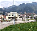 Train station
 -
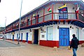 Colonial building
 -
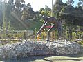 Monument to the salt miners
 -
 Cathedral
 -
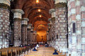 Cathedral interior
 -
 El Abra archaeological site
 -
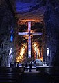 Salt Cathedral


.JPG)
.JPG)


See also
- Muisca economy
- Nemocón, Salt Cathedral of Zipaquirá
- Cathedral of the Most Holy Trinity, Saint Anthony of Padua and Our Lady of Assumption of Zipaquirá
References
- ^ Citypopulation.de
- ^ Espejo Olaya, 1999, p.1126
- ^ Clima: Climatografía de la principales ciudades
- ^ Parkin Daniels, Joe (28 July 2019). "Egan Bernal wins Tour de France and all of Colombia celebrates". The Guardian. Retrieved 28 July 2019.
Bibliography
- Espejo Olaya, Maria Bernarda (1999). Notas sobre toponimia en algunas coplas colombianas [Notes about toponomy of some Colombian ballads - Thesaurus] (PDF) (in Spanish). Vol. Tomo LIV, Núm. 3. pp. 1102–1157.
- ISBN 978-958-719-046-5.
External links
| Gold |  | |
|---|---|---|
| Silver | ||
| Platinum | ||
| Nickel | ||
| Coltan | ||
| Emeralds | ||
| Coal |
| |
| Salt | ||
| Sources | ||
| |||||||||||||||||||
| |||||||||||||||||||
| |||||||||||||||||||
| |||||||||||||||||||
| Neighbours |
| ||||||||||||||||||
Research and collections | |||||||||
|---|---|---|---|---|---|---|---|---|---|
| |||||||||
| Authority control databases: National |
|---|