Файл:Afghanistan map - security by district and opium poppy cultivation by province 2007 - 2008.png
Afghanistan_map_-_security_by_district_and_opium_poppy_cultivation_by_province_2007_-_2008.png (466 × 330 пкс, размер файла: 46 КБ, MIME-тип: image/png)
Этот файл находится на Викискладе. Сведения о нём показаны ниже.
Викисклад — централизованное хранилище для свободных файлов, используемых в проектах Викимедиа.
|

|
Эту военную карту желательно воссоздать или аккуратно преобразовать в векторный формат
Commons:Media for cleanup. Если вам уже сейчас доступна векторная версия данного изображения, загрузите её, пожалуйста, а затем замените этот шаблон на следующий: {{Vector version available |Имя загруженного файла.svg}}. |
Краткое описание
| Описание |
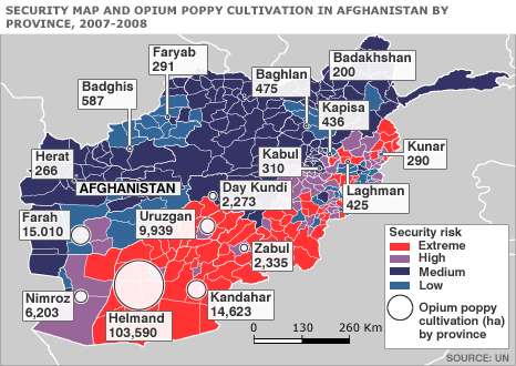
English: Map of Afghanistan showing the security situation by district and opium cultivation by province in the period 2007 to 2008. |
| Дата | |
| Источник | http://news.bbc.co.uk/2/hi/south_asia/7663204.stm |
| Автор | United Nations Department of Safety and Security |
Лицензирование
| This image is a map derived from a United Nations map.
Unless stated otherwise, UN maps are to be considered in the public domain. This applies worldwide. UN maps are, in principle, open source material and you can use them in your work or for making your own map. UN requests however that you delete the UN name, logo and reference number upon any modification to the map. Content of your map will be your responsibility. You can state in your publication, if you wish, something like: based on UN map … (map name, map number, revision number and date). See: Geospatial Information Section. And: Geospatial, location data for a better world. |
 |
Исходный журнал загрузок
| Дата/время | Размеры | Участник | Примечание |
|---|---|---|---|
| 11 октября 2008, 06:52:24 | 466 × 330 (41766 bytes) | Le Behnam (обсуждение · вклад) | {{Information |Description={{en|1=Map of Afghanistan showing the security situation by district and opium cultivation by province in the period 2007 to 2008.}} |Source=http://news.bbc.co.uk/2/hi/south_asia/7663204.stm |Author=United Nations Department of |
История файла
Нажмите на дату/время, чтобы посмотреть файл, который был загружен в тот момент.
| Дата/время | Миниатюра | Размеры | Участник | Примечание | |
|---|---|---|---|---|---|
| текущий | 15:54, 10 августа 2014 | | 466 × 330 (46 КБ) | GifTagger | Bot: Converting file to superior PNG file. (Source: [[File:Afghanistan_map_-_security_by_district_and_opium_poppy_cultivation_by_province_2007_-_2008.gif|Afghanistan_map_-_security_by_district_and_opium_poppy_cultivation_by_province... |
Использование файла
Следующая страница использует этот файл:
Глобальное использование файла
Данный файл используется в следующих вики:
- Использование в ar.wikipedia.org
- Использование в ca.wikipedia.org
- Использование в ce.wikipedia.org
- Использование в el.wikipedia.org
- Использование в en.wikipedia.org
- Использование в fr.wikipedia.org
- Использование в hu.wikipedia.org
- Использование в hy.wikipedia.org
- Использование в ja.wikipedia.org
- Использование в nl.wikipedia.org
- Использование в pt.wikipedia.org
- Использование в ro.wikipedia.org
- Использование в www.wikidata.org