
College Hill, Cincinnati
College Hill | |
|---|---|
.jpg) Hamilton Avenue in College Hill, Cincinnati | |
|
Cincinnati, Ohio | |
| Country | United States |
| State | Ohio |
| County | Hamilton |
| City | Cincinnati |
| Population (2020) | |
| • Total | 16,039 |
College Hill is one of the 52
History
In 1813-14, William Cary, having migrated from New Hampshire to Cincinnati in 1802,[3] purchased 491 acres (1.99 km2) north of Cincinnati along what is now Hamilton Avenue (U.S. Route 127). Cary built a log cabin and moved his family to the area, then part of Mill Creek Township.[4] In 1833, Cary's son Freeman G. Cary established Pleasant Hill Academy for boys on part of his land. The academy became an agricultural school called Farmer's College (for which the area was renamed) in 1846. That school became Belmont College in 1885, and then formed the core of the Ohio Military Institute in 1890. A separate school, the Ohio Female College, was founded in 1852 by Reverend John Covert and operated until 1873[5][6] when it was sold to build the Cincinnati Sanitarium, the first private US psychiatric facility not on the East Coast.[7]
The development of the area was expedited by the introduction of a railroad line in 1851 and horsecar service in the 1860s. College Hill was incorporated as a village in 1866, then annexed to the city of Cincinnati in stages in 1911, 1915 and 1923.[6]
Several buildings in the neighborhood are listed on the National Register of Historic Places, including
Demographics
| Year | Pop. | ±% | ||
|---|---|---|---|---|
| 1950 | 10,492 | — | ||
| 1960 | 15,198 | +44.9% | ||
| 1965 | 19,632 | +29.2% | ||
| 1970 | 21,590 | +10.0% | ||
| 1980 | 17,327 | −19.7% | ||
| 1990 | 15,785 | −8.9% | ||
| 2000 | 15,269 | −3.3% | ||
| 2010 | 14,133 | −7.4% | ||
| 2020 | 16,039 | +13.5% | ||
| ||||
As of the census of 2020, there were 16,039 people living in the neighborhood. There were 7,624 housing units. The racial makeup of the neighborhood was 32.6%
There were 7,263 households, out of which 54.1% were families. 42.6% of all households were made up of individuals.[2]
22.8% of the neighborhood's population were under the age of 18, 59.2% were 18 to 64, and 18.0% were 65 years of age or older. 44.7% of the population were male and 55.3% were female.[2]
According to the U.S. Census
Notable people
- John E. Bruce, former mayor[8]
- Samuel Fenton Cary, representative and temperance movement leader
- Cornelia Laws St. John, poet
Gallery
-
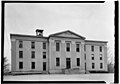 Farmer's College, built 1848 (photo 1934)
 -
 Advertisement for Ohio Female College, 1857
 -
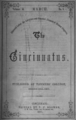 Cover of Cincinnatus, publication of Farmer's College, 1857


References
- ISBN 0-7385-1955-3.
- ^ a b c d e "College Hill 2020 Statistical Neighborhood Approximation" (PDF). City of Cincinnati. Retrieved 13 December 2023.
- ^ "My Genealogy Pages". homepages.rootsweb.ancestry.com. Retrieved 2008-06-28.
- ^ “History of Cincinnati and Hamilton County, Ohio,” http://www.heritagepursuit.com/Hamilton/HamiltonChapXXXIII.htm. Accessed 3/16/2008.
- ^ The Ohio Channel : Your State : Remarkable Ohio : Marker Details[permanent dead link]
- ^ a b Cincinnati: A Guide to the Queen City and Its Neighbors, The Wisen-Hart Press, 1943, p. 402.
- ^ Ohio Female College, Ohio History Central, July 1, 2005.
- ^ "Obituary for John e. Bruce". The Cincinnati Enquirer. 18 August 1924. p. 2.
External links
- College Hill Community website Archived 2019-05-06 at the Wayback Machine
