
Hudson Highlands

The Hudson Highlands are mountains on both sides of the Hudson River in New York state lying primarily in Putnam County on its east bank and Orange County on its west. They continue somewhat to the south in Westchester County and Rockland County, respectively. The highlands are a subrange of the Appalachian Mountains.
North to south they fall between
The Hudson River enters this region in the south at Dunderberg Mountain near Stony Point, and from the north in the vicinity of Breakneck Ridge and Storm King Mountain near Cornwall, New York. These highlands have played a significant role in America's environmental, cultural, and military history.
Geology
The bedrock of the Highlands is part of the
History
Prior to

The mountains became strategically important during the
Several decades after independence, Thomas Cole started an artistic movement by painting America's wild and rugged landscapes— especially, at first, the Highlands— with the stark contrasts and shadows they offered, in a way that suggested raw nature, a world reborn. After the movement had faded, a critic derisively referred to the movement as the Hudson River School; the name stuck as the label for the new nation's first homegrown artistic movement.
In the early 20th century, in response to damage caused by quarrymen and loggers in the Highlands, local conservationists began to press for public ownership of the area's woods and mountains. Their efforts paid off in the first of several state parks that now blanket the chain.
Later that century, an ambitious power-generating plan that would have dug into Storm King Mountain led to a landmark lawsuit by environmental groups that made history when the judge ruled that aesthetic impacts of such large projects could be considered and that a coalition of citizen groups had legal standing. This landmark lawsuit formed the basis for a large body of case law concerning environmentalism.
Mountains of the Hudson Highlands


East (north to south)
- Bald Hill
- Lamb's Hill
- Lamb's Hill West
- Beacon Mountain (North and South)
- Scofield Ridge (highest point in Putnam County, in Philipstown)[1]
- Sugarloaf Mountain
- Breakneck Ridge
- Bull Hill aka Mt. Taurus
- South Redoubt and North Redoubt aka Fort Hill
- Fort Defiance Hill
- Denning Hill
- Sunset Point
- Sugarloaf Hill
- White Rock
- Canada Hill
- Anthony's Nose
- Manitou Mountain
West (north to south)
- Storm King Mountain
- Black Rock
- Crow's Nest
- Popolopen Torne
- Bear Mountain
- West Mountain
- Bald Mountain
- Spy Rock
- Eagles Cliff
- Dunderberg Mountain
- Long Mountain
- Sutherland Ridge
- Stillman Hill
- Arthur Hill
- Chatfield Hill
- Buckberg
Protected areas of the Hudson Highlands
- Bear Mountain State Park
- Black Rock Forest
- Harriman State Park
- Hudson Highlands State Park
- Manitoga
- Sterling Forest State Park
- Storm King State Park
Gallery
-
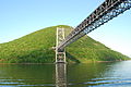 View from Hudson River with Bear Mountain Bridge in foreground
 -
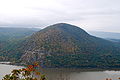
 Breakneck Ridge from across the Hudson River
 -
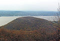
 Sugarloaf Hillon the east bank of the river
 -
 Looking east fromPopolopen Torne, with Bear Mountain Bridge across the Hudson River
 -
 Popolopen Bridge on US Route 9W
 -
 Storm King and New York State Route 218 as seen from atop Breakneck Ridge
 -
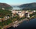 Central campus ofWest Pointlooking north
 -

-
 Sugarloaf Mountain from the Breakneck Bypass Trail


See also
References
- ^ United States Geological Survey (2007). "Scofield Ridge". United States Geological Survey. Retrieved 2008-01-15.
External links
- USGS - The Highlands Province
- NYS - Hudson Highlands State Park Archived 2005-12-17 at the Wayback Machine