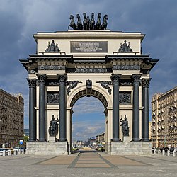
Kutuzovsky Prospekt
|
Top to bottom: | |
| Coordinates | 55°44′08″N 37°30′47″E / 55.73556°N 37.51306°E |
|---|---|
Kutuzovsky Moskva River to the junction with Rublyovskoye Shosse; past this point, the route changes its name to Mozhaiskoye Shosse.
Overview
Present-day Kutuzovsky Prospekt emerged between 1957 and 1963, incorporating part of the old Mozhaiskoye Schosse (buildings no. 19 to 45) that was rebuilt in grand
New Arbat
redevelopment, the segment between the Garden Ring and Novoarbatsky Bridge was assigned to New Arbat (then known as Prospekt Kalinina).
The eastern part of the Prospekt (within
social elite, including Leonid Brezhnev's family. The segment west of the Poklonnaya Hill is less affluent, with standardized 1950s–1980s housing; one notable exception is the luxury Edelweiss apartment tower
built in the 2000s.
Notable buildings

Notable buildings and institutions include:
- 2 - Hotel Ukraina
- 26 - Apartment building that housed Leonid Brezhnev, Mikhail Suslov, and Yuri Andropov
- 32 - Sberbank City
- 38 - Borodino Panoramamuseum
- The Poklonnaya Hill Archon 1941–1945 Victory Square
- Museum of Great Patriotic War and Victory Park (ru) (Парк Победы, Victory Park) on the site of the former Poklonnaya Hill.
See also
- Dorogomilovo District contains the eastern, affluent segment of Kutuzovsky Prospekt
- Kutuzovsky Prospekt is a glossy "lifestyle" magazine [1]
External links
- (in Russian) official site of Dorogomilovo District Archived 2007-03-07 at the Wayback Machine


