
Montebello Islands

20°28′S 115°32′E / 20.46°S 115.54°E


The Montebello Islands, also rendered as the Monte Bello Islands, are an
Description
The islands of the archipelago have a collective land area of about 22 km2 (8.5 sq mi). The largest islands, Hermite and Trimouille, have areas of 1,022 ha (2,525 acres) and 522 ha (1,290 acres) respectively. They consist of
Wildlife
Birds
The islands have been identified by
Mammals
-
 The islands are an important site for sooty oystercatchers
 -
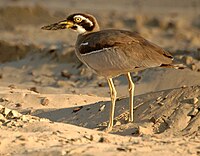 Beach stone-curlews inhabit the islands
 -
 Mala have been introduced to the islands


History
Archaeological remains show that the islands were visited by indigenous Australians until about 8248 BP, when a period of global warming and rising sea levels caused the Montebellos to become separated from the mainland, and forced abandonment.[4][5]
In 1622
In 1801
The islands were economically significant for
British nuclear weapons tests
The Montebello Islands were the site of three atmospheric nuclear weapon tests by the
HMS Plym, moored in Main Bay on Trimouille Island, was the site of Operation Hurricane, the first-ever atomic weapon tested by the United Kingdom, on 3 October 1952.[11][12]
While
Islands
Of the smaller islands, the largest are:
- North-West Island
- Primrose Island
- Bluebell Island
- Alpha Island
- Crocus Island
- Campbell Island
- Delta Island
- Renewal Island
- Ah Chong Island
There are also 10 named groups of small islets, whose individual islands have not yet been named:
- Corkwood Islands
- Fig Islands
- Hakea Islands
- Jarrah Islands
- Jasmine Islands
- Karri Islands
- Marri Islands
- Minnieritchie Islands
- Mulga Islands
- Quandong Islands
References
- ^ "Management Plan for the Montebello/Barrow Islands Marine Conservation Reserves 2007–2017" (PDF). Perth, WA: Department of Environment and Conservation. 16 January 2018. Retrieved 13 August 2021.
- ^ a b c BirdLife International. (2011). Important Bird Areas factsheet: Montebello Islands. Downloaded from http://www.birdlife.org on 16/08/2011.
- ^ "IBA: Montebello Islands". Birdata. Birds Australia. Retrieved 16 August 2011.
- .
- ISBN 9781407301037. Retrieved 18 May 2023.
- JSTOR 1786489.
- ^ Sainsbury, W. Noel, ed. (1884). Calendar of State Papers, Colonial Series, East Indies, China and Persia, 1625-1629. London: Longman, Green, Longman & Roberts. p. 13.
- ^ Stansbury, Myra (January 1986). A survey of sites associated with early pearling activities in the Monte Bello Islands, Western Australia (PDF). Fremantle: Department of Maritime Archaeology, Western Australian Maritime Museum. Retrieved 11 August 2021.
- ^ Cooper, M.B.; Hartley, B.M. (April 1979). Residual Radioactive Contamination of the Monte Bello Islands from Nuclear Weapon Tests Conducted in 195 and 1956 (PDF). Australian Radiation Laboratory.
- ISBN 978-1-5381-0684-6.
- ISBN 978-94-017-0496-0.
- ISBN 978-1-137-60133-9.
- ^ "British Nuclear Testing". Britain's Nuclear Weapons. 23 August 2007. Retrieved 13 August 2021.
- ISSN 0262-4079. Retrieved 13 August 2021.
- ISBN 978-0-7336-3205-1.
- ^ Cross, Roger. (2001). Fallout. Wakefield Press. (p.179).
Further reading
- Acaster, Ray (1995). "British nuclear testing at the Monte Bello Islands". Early Days Vol. 11, no. 1. pp. 66–80.
- Arnold, Lorna; and Smith, Mark (2006). ISBN 1-4039-2102-4
- Bird, Peter (1989). Operation Hurricane. Square One Publications: Worcester. (First published in 1953). ISBN 1-872017-10-X
- Burbidge, A. A. (1971). The Fauna and Flora of the Monte Bello Islands. Department of Fisheries and Fauna: Perth.
- Deegan, P. M. (1992). Monte Bello and Lowendal Islands: bibliography, summary report of marine resources. Dept. of Conservation and Land Management: Perth.
- ISBN 978-0-522-85260-8
- Fornasiero, Jean; Monteath, Peter; and West-Sooby, John (2004). Encountering Terra Australis: the Australian voyages of Nicholas Baudin and Matthew Flinders. Wakefield Press: Kent Town, South Australia. ISBN 1-86254-625-8
- Horner, Frank (1987). The French Reconnaissance: Baudin in Australia 1801–1803. Melbourne University Press: Melbourne. ISBN 0-522-84339-5.
- Tuckfield, Trevor (1 August 1951). "The Monte Bello Islands". Walkabout, Vol. 17, No. 8. pp. 33–34.
External links
- Video footage of the Operation Hurricane detonation on Trimouille Island in 1951
- Nicolas Baudin's Scientific Expedition to the Terres Australes by Steve Reynolds – Marine Life Society of South Australia Inc.
- Details of a feral cat eradication program on Hermite Island in 1999
- Nuclear testing details
| International | |
|---|---|
| National | |